Difference between revisions of "2012-05-21 49 10"
imported>Danatar (Planning) |
imported>Danatar m (nothing to see here yet) |
||
| Line 8: | Line 8: | ||
== Location == | == Location == | ||
| − | Today's location is | + | Today's location is at the edge of a field near Uffenheim. |
Country: Germany; state: Bayern (Bavaria, EU:DE:BY); administrative region: Mittelfranken; district: "Neustadt an der Aisch - Bad Windsheim" (yes, that's one name) | Country: Germany; state: Bayern (Bavaria, EU:DE:BY); administrative region: Mittelfranken; district: "Neustadt an der Aisch - Bad Windsheim" (yes, that's one name) | ||
| − | Weather: forecast | + | Weather: forecast said sunny with clouds, reality was more on the clouds' side |
| Line 18: | Line 18: | ||
===Planning=== | ===Planning=== | ||
I have to work the late shift, so I should be able to make my Geohashing Day expedition in the morning. The plan is to take the train from Würzburg to Uffenheim, walk 2 km to the hashpoint, celebrate, walk back to the train station, take the train home, go to work. | I have to work the late shift, so I should be able to make my Geohashing Day expedition in the morning. The plan is to take the train from Würzburg to Uffenheim, walk 2 km to the hashpoint, celebrate, walk back to the train station, take the train home, go to work. | ||
| − | Possible trains start at 08:41 or 09:41, arriving 33 minutes later, with the return train | + | Possible trains start at 08:41 or 09:41, arriving 33 minutes later, with the return train at 10:41 or 11:41. This means 87 minutes for walking 4 km and celebrating. |
| + | |||
| + | |||
| + | ===Expedition=== | ||
| + | |||
| + | ... | ||
| + | |||
| − | |||
<gallery> | <gallery> | ||
| − | + | File:2012-05-21 49 10 uffenheim.jpg|Uffenheim train station | |
| + | File:2012-05-21 49 10 bruecke.jpg|The route went over a bridge... | ||
| + | File:2012-05-21 49 10 treppe.jpg|...up some stairs... | ||
| + | File:2012-05-21 49 10 pfad.jpg|...and along a narrow path... | ||
| + | File:2012-05-21 49 10 near.jpg|...to the hashpoint. | ||
| + | File:2012-05-21 49 10 gps.jpg|GPS | ||
| + | File:2012-05-21 49 10 hp.jpg|Coordinates reached! | ||
| + | File:2012-05-21 49 10 pano.jpg|panorama | ||
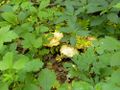
| + | File:2012-05-21 49 10 marker.jpg|I picked some flowers | ||
| + | File:2012-05-21 49 10 hunde.jpg|hashdogs | ||
| + | File:2012-05-21 49 10 pilz.jpg|mushroom | ||
| + | File:2012-05-21 49 10 ameisen1.jpg|ants slicing their food... | ||
| + | File:2012-05-21 49 10 ameisen2.jpg|... and bringing it home | ||
</gallery> | </gallery> | ||
[[Category:Expeditions]] | [[Category:Expeditions]] | ||
[[Category:Expeditions with photos]] | [[Category:Expeditions with photos]] | ||
| − | [[Category:Coordinates reached | + | [[Category:Coordinates reached]] |
| − | |||
[[Category:Danatar]] | [[Category:Danatar]] | ||
Revision as of 18:38, 21 May 2012
| Mon 21 May 2012 in Bamberg: 49.5433661, 10.2626120 geohashing.info google osm bing/os kml crox |
Location
Today's location is at the edge of a field near Uffenheim.
Country: Germany; state: Bayern (Bavaria, EU:DE:BY); administrative region: Mittelfranken; district: "Neustadt an der Aisch - Bad Windsheim" (yes, that's one name)
Weather: forecast said sunny with clouds, reality was more on the clouds' side
Danatar
Planning
I have to work the late shift, so I should be able to make my Geohashing Day expedition in the morning. The plan is to take the train from Würzburg to Uffenheim, walk 2 km to the hashpoint, celebrate, walk back to the train station, take the train home, go to work. Possible trains start at 08:41 or 09:41, arriving 33 minutes later, with the return train at 10:41 or 11:41. This means 87 minutes for walking 4 km and celebrating.
Expedition
...
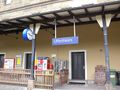
Uffenheim train station
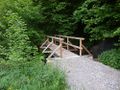
The route went over a bridge...
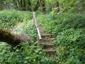
...up some stairs...
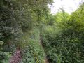
...and along a narrow path...
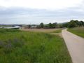
...to the hashpoint.
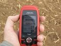
GPS
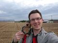
Coordinates reached!

panorama
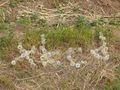
I picked some flowers

hashdogs
mushroom

ants slicing their food...

... and bringing it home


