Difference between revisions of "2012-07-06 45 -122"
From Geohashing
imported>Kydlt (→Photos) |
imported>FippeBot m (Location) |
||
| (2 intermediate revisions by one other user not shown) | |||
| Line 37: | Line 37: | ||
Image:2012-07-06 street signs.jpg|The nearest corner. | Image:2012-07-06 street signs.jpg|The nearest corner. | ||
Image:2012-07-06 track.jpg|Here is a screencapture of my track. I turned around at the end of the block, there are a clump of breadcrumbs as i parked and got out, and then another bunch as I shifted around in the center of the street. | Image:2012-07-06 track.jpg|Here is a screencapture of my track. I turned around at the end of the block, there are a clump of breadcrumbs as i parked and got out, and then another bunch as I shifted around in the center of the street. | ||
| + | File:2012-07-06 45 -122 routes.JPG|Kydlt's screencapture with Michael and Molly's subsequent route through the hashpoint area superimposed on it! | ||
</gallery> | </gallery> | ||
| Line 54: | Line 55: | ||
| name = [[User:Michael5000|Michael5000]] | | name = [[User:Michael5000|Michael5000]] | ||
}} | }} | ||
| + | {{location|US|WA|CR}} | ||
Latest revision as of 04:56, 13 August 2019
| Fri 6 Jul 2012 in 45,-122: 45.6551710, -122.6795101 geohashing.info google osm bing/os kml crox |
Location
On 46th Street in Vancouver.
Participants
- Michael5000
- Molly
Plans
- Kydlt: On the way if I go that way.
- Michael5000: It was a very accessible hashpoint, but didn't look especially interesting. So, I thought maybe a running expedition would be in order. Then, it occurred to me that my running buddy Molly lived along the way. She bought in, and it became a drag-along. She was very sporting when I admitted that it was a geohashing expedition.
Expedition
- Kydlt: I drove by on my way to my children's house. There were some neighbors across Grant St watching me, we smiled and waved at one another, but I didn't have the time to stop and explain what geohashing is all about. I seem to be out of chalk so I made a sign on some 2" AL tape and stuck it on the road. Perhaps the neighbors cleaned up after me.
- Michael5000: We parked not far off the freeway exit by Hazel Dell. Rather than march right up to the hashpoint, we snuck up on it from behind, by running down the Burnt Bridge trail and coming back around on pleasant evening suburban streets. We probably crossed the hashpoint at ~ 8:15 p.m., and commemorated the moment with a little geohash dance. We didn't see any marker, however.
Returned to the truck and the State of Oregon without further incident. 4.25 miles for the run.
Photos
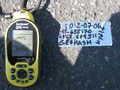
This time I used silver tape as a marker. I couldn't find my chalk.
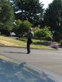
I tried to get a photo using the selftimer but my timing was off.
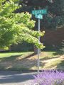
The nearest corner.
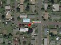
Here is a screencapture of my track. I turned around at the end of the block, there are a clump of breadcrumbs as i parked and got out, and then another bunch as I shifted around in the center of the street.
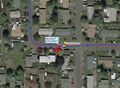
Kydlt's screencapture with Michael and Molly's subsequent route through the hashpoint area superimposed on it!


Achievements
Michael5000 earned the Drag-along achievement
|