Difference between revisions of "2012-07-14 46 7"
imported>TheOneRing (→TheOneRing) |
imported>NWoodruff |
||
| Line 37: | Line 37: | ||
{{Public transport geohash | latitude = 46 | longitude = 7 | date = 2012-07-14 | name = TheOneRing }} | {{Public transport geohash | latitude = 46 | longitude = 7 | date = 2012-07-14 | name = TheOneRing }} | ||
{{xkcd centurion | count = 4 | name = TheOneRing}} | {{xkcd centurion | count = 4 | name = TheOneRing}} | ||
| + | [[Category:Expeditions]] | ||
| + | [[Category:Expeditions with photos]] | ||
| + | [[Category:Coordinates reached]] | ||
Revision as of 22:50, 23 August 2012
| Sat 14 Jul 2012 in 46,7: 46.9940494, 7.7526735 geohashing.info google osm bing/os kml crox |
Contents
[hide]Location
The geohash is near Zollbrück (canton Bern).
Who went
TheOneRing - by public transport.
The Expedition
TheOneRing
The geohash attempt last Thursday was unsuccessful, so I desperately wanted to go on a new try. The geohash was near that of May 27th, which was my last succesful one...mere chance, I think.
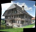
Quite unsurprisingly, the way by train was the same, just a bit further. From the station it was 2.2km, as the bird flies, but that would have been straight up the hill. The route was mostly on paved streets...quite comfortable. After reaching the geohash, I had a rest with schnitzel and something to drink. I walked a bit more up the hill to take photographs of the surrounding and the geohash. The panoramic views of the valley of the river Emme (yes, it is the "Emmental", like the cheese) are very impressive.
I had to get the train back home, so I had to leave the geohash couple of minutes before 4pm. Nevertheless, I think this counts as a Saturday meetup.
Photos
TheOneRing
Achievement
TheOneRing earned the Land geohash achievement
|
TheOneRing earned the Picnic achievement
|
TheOneRing earned the Public transport geohash achievement
|
TheOneRing earned the xkcd Nullaturion achievement
|


