Difference between revisions of "2012-07-16 59 16"
imported>The ru m |
imported>The ru m |
||
| Line 10: | Line 10: | ||
I routinely bike in this area so I was already familiar with the route. | I routinely bike in this area so I was already familiar with the route. | ||
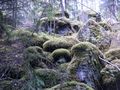
| − | I cycled from Västerås, north through Hökåsen, then zigzaging along small roads to avoid traffic. I planned to approach the hashpoint on a dirt road from the south but ran into a "vehicles prohibited" sign. I still had a couple of kilometers to go and didn't feel like walking so I decided on an alternative approach from the northeast. I left my bike near a meadow and walked the last 400 m along a logging trail. The hashpoint was in a typical scandinavian troll forest. Afterwards I continued cycling north through Munga, Haraker and back home through Skultuna. | + | I cycled from Västerås, north through Hökåsen, then zigzaging along small roads to avoid traffic. I planned to approach the hashpoint on a dirt road from the south but ran into a "vehicles prohibited" sign. I still had a couple of kilometers to go and didn't feel like walking so I decided on an alternative approach from the northeast. I left my bike near a meadow and walked the last 400 m along a logging trail. The hashpoint was in a typical scandinavian troll forest. Afterwards I continued cycling north through Munga, Haraker and back home through Skultuna. Total distance covered: 47 km. |
| + | |||
| + | |||
| + | {{Bicycle geohash | ||
| + | | latitude = 59 | ||
| + | | longitude = 16 | ||
| + | | date = 2012-07-16 | ||
| + | | name = [[User:The_ru|the_ru]] | ||
| + | | image = 2012-07-16_59_16_bike.jpg | ||
| + | }} | ||
| + | |||
<gallery perrow="4"> | <gallery perrow="4"> | ||
| − | Image:2012-07- | + | Image:2012-07-16_59_16_farmland.jpg | Sweden has farmland too! |
| − | Image:2012-07- | + | Image:2012-07-16_59_16_green.jpg | I don't know what they're growing here, but it's pretty |
| − | Image:2012-07- | + | Image:2012-07-16_59_16_prohibited.jpg |
| − | Image:2012-07- | + | Image:2012-07-16_59_16_sheeple.jpg | Sheeple |
| − | Image:2012-07- | + | Image:2012-07-16_59_16_bridge.jpg | Concrete bridge, visible on sattelite photos |
| − | Image:2012-07- | + | Image:2012-07-16_59_16_the_ru.jpg |
| − | Image:2012-07- | + | Image:2012-07-16_59_16_troll_forest.jpg |
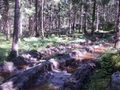
| − | Image:2012-07- | + | Image:2012-07-16_59_16_trail.jpg |
| − | Image:2012-07- | + | Image:2012-07-16_59_16_footwear.jpg | Inappropriate footwear |
| − | Image:2012-07- | + | Image:2012-07-16_59_16_lichen.jpg | I found a large boulder covered in lichen. Hand included for size comparison. |
| − | Image:2012-07- | + | Image:2012-07-16_59_16_mungasjon.jpg | Mungasjön |
| − | Image:2012-07- | + | Image:2012-07-16_59_16_bike.jpg | My bike |
| − | Image:2012-07- | + | Image:2012-07-16_59_16_gps.jpg | I still haven't found my GPS mount, some insulation tape will have to do |
</gallery> | </gallery> | ||
Revision as of 16:27, 16 July 2012
| Mon 16 Jul 2012 in 59,16: 59.7328832, 16.5090901 geohashing.info google osm bing/os kml crox |
Location
In the forest south of Mungasjön, near Västerås, Sweden.
the ru
I routinely bike in this area so I was already familiar with the route.
I cycled from Västerås, north through Hökåsen, then zigzaging along small roads to avoid traffic. I planned to approach the hashpoint on a dirt road from the south but ran into a "vehicles prohibited" sign. I still had a couple of kilometers to go and didn't feel like walking so I decided on an alternative approach from the northeast. I left my bike near a meadow and walked the last 400 m along a logging trail. The hashpoint was in a typical scandinavian troll forest. Afterwards I continued cycling north through Munga, Haraker and back home through Skultuna. Total distance covered: 47 km.
the_ru earned the Bicycle geohash achievement
|
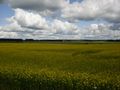
Sweden has farmland too!
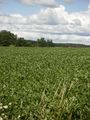
I don't know what they're growing here, but it's pretty
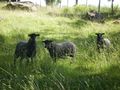
Sheeple
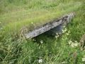
Concrete bridge, visible on sattelite photos
- 2012-07-16 59 16 the ru.jpg
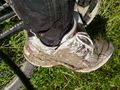
Inappropriate footwear
- 2012-07-16 59 16 lichen.jpg
I found a large boulder covered in lichen. Hand included for size comparison.
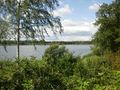
Mungasjön
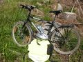
My bike
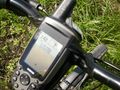
I still haven't found my GPS mount, some insulation tape will have to do


