Difference between revisions of "2012-08-09 52 0"
imported>Sourcerer |
imported>FippeBot m (Location) |
||
| (7 intermediate revisions by 2 users not shown) | |||
| Line 9: | Line 9: | ||
== Location == | == Location == | ||
| − | [[User:Sourcerer|Sourcerer]] failed to reach the hashpoint in a very muddy pig field. | + | 1) [[User:Sourcerer|Sourcerer]] failed to reach the hashpoint in a very muddy pig field. |
== Participants == | == Participants == | ||
| Line 19: | Line 19: | ||
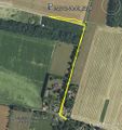
*Not reached about one hour ago due to a pig farm field. -- [[User:Sourcerer|Sourcerer]] [http://www.openstreetmap.org/?lat=52.312511801719666&lon=-0.690963864326477&zoom=16&layers=B000FTF @52.3125,-.6910] 11:35, 09 August 2012 (GMT+01:00) | *Not reached about one hour ago due to a pig farm field. -- [[User:Sourcerer|Sourcerer]] [http://www.openstreetmap.org/?lat=52.312511801719666&lon=-0.690963864326477&zoom=16&layers=B000FTF @52.3125,-.6910] 11:35, 09 August 2012 (GMT+01:00) | ||
| − | Neil was on | + | 1 of 5 today :: [[2012-08-09_52 0]] :: [[2012-08-09_52_-0]] :: [[2012-08-09_52_-1]] :: [[2012-08-09_53_-2]] :: [[2012-08-09_56_-2]] |
| + | |||
| + | Neil was geohashing on the way to a wedding in Scotland. This was attempt 1 of 5 on this day. The hashpoint was in a farmer's field full of pigs wallowing contentedly in deep mud. Neil opted '''not''' to paddle the last few metres to reach the hashpoint. It was coordinates not reached due to lack of public access, biosecurity concerns for the pigs and a desire not to get the footwear too muddy before the wedding on Sunday. Yes! Neil will be wearing his geohashing sandals to the wedding! The terrain is very nice here with Thetford forest nearby. | ||
== Photos == | == Photos == | ||
| − | <gallery | + | <gallery> |
Image:2012-08-09 52 0 Sourcerer 1.jpg|Google Earth track | Image:2012-08-09 52 0 Sourcerer 1.jpg|Google Earth track | ||
Image:2012-08-09 52 0 Sourcerer 2.jpg|The Muddy Farm | Image:2012-08-09 52 0 Sourcerer 2.jpg|The Muddy Farm | ||
</gallery> | </gallery> | ||
| − | == | + | {{Sourcerer_links |
| − | + | | prev = 2012-08-08 52 0 | |
| − | + | | curr = 2012-08-09 52 0 | |
| + | | next = 2012-08-09 52 -0 | ||
| + | | date = 2012-08-09 | ||
| + | }} | ||
[[Category:Expeditions]] | [[Category:Expeditions]] | ||
[[Category:Expeditions with photos]] | [[Category:Expeditions with photos]] | ||
[[Category:Coordinates not reached]] | [[Category:Coordinates not reached]] | ||
| + | [[Category:Not reached - No public access]] | ||
| + | {{location|GB|ENG|SFK}} | ||
Latest revision as of 05:28, 13 August 2019
| Thu 9 Aug 2012 in Cambridge: 52.3125551, 0.6909587 geohashing.info google osm bing/os kml crox |
Contents
Location
1) Sourcerer failed to reach the hashpoint in a very muddy pig field.
Participants
Expedition - Failed
- Not reached about one hour ago due to a pig farm field. -- Sourcerer @52.3125,-.6910 11:35, 09 August 2012 (GMT+01:00)
1 of 5 today :: 2012-08-09_52 0 :: 2012-08-09_52_-0 :: 2012-08-09_52_-1 :: 2012-08-09_53_-2 :: 2012-08-09_56_-2
Neil was geohashing on the way to a wedding in Scotland. This was attempt 1 of 5 on this day. The hashpoint was in a farmer's field full of pigs wallowing contentedly in deep mud. Neil opted not to paddle the last few metres to reach the hashpoint. It was coordinates not reached due to lack of public access, biosecurity concerns for the pigs and a desire not to get the footwear too muddy before the wedding on Sunday. Yes! Neil will be wearing his geohashing sandals to the wedding! The terrain is very nice here with Thetford forest nearby.
Photos
Expeditions and Plans
| 2012-08-09 | ||
|---|---|---|
| Atlanta, Georgia | NWoodruff | In a well over grown lot in Vinings. |
| Youngstown, Ohio | User:Fezzic181 | Found the spot out in the middle of the state game lands. |
| Billings, Montana | Rory | Lake Elmo State Park north of Billings, MT. The actual hash point is in th... |
| Northampton, United Kingdom | Sourcerer | 2) On an urban public path through attractive lawns and trees in Wellingbor... |
| Birmingham, United Kingdom | Sourcerer | 3) A few metres off a public footpath in a hay field. This was near the Gra... |
| Cambridge, United Kingdom | Sourcerer | 1) Sourcerer failed to reach the hashpoint in a very muddy pig field. |
| Amsterdam, Netherlands | Marvyn | Behind a container-like building in some shrubs in an urban area in Hoofddo... |
| Manchester, United Kingdom | Sourcerer | 4) Close to junction 12 on the M56. The hashpoint was on or very close to t... |
| Dundee, United Kingdom | Sourcerer | 5) Beside the coast road east of St. Andrews, Fife, Scotland, UK. |
Sourcerer's Expedition Links
2012-08-08 52 0 - 2012-08-09 52 0 - 2012-08-09 52 -0 - KML file download of Sourcerer's expeditions for use with Google Earth.

