Difference between revisions of "2012-08-26 59 18"
imported>Per S |
imported>FippeBot m (Location) |
||
| (3 intermediate revisions by one other user not shown) | |||
| Line 1: | Line 1: | ||
| − | + | {| width="100%" border=0 cellpadding=0 cellspacing=0 style="border: 0; border-collapse: collapse; border-spacing: 0; margin: 0; padding: 0" | |
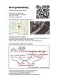
| − | [[Image: | + | | align="left" valign="top" style="padding: 0.5em 1em 0.5em 0" | [[Image:2012-08-26 59 18 09 Geohasher.jpg|border|467px]] |
| − | + | | align="right" valign="top" | {{meetup graticule | |
| − | |||
| − | |||
| − | |||
| − | |||
| − | {{meetup graticule | ||
| lat=59 | | lat=59 | ||
| lon=18 | | lon=18 | ||
| date=2012-08-26 | | date=2012-08-26 | ||
| + | | graticule_name=Stockholm | ||
| + | | graticule_link=Stockholm, Sweden | ||
}} | }} | ||
| − | + | |} | |
| + | |||
__NOTOC__ | __NOTOC__ | ||
| + | |||
== Location == | == Location == | ||
In a south bound lane on Gamla Nynäsvägen close to Haninge Golfhall in Jordbro. | In a south bound lane on Gamla Nynäsvägen close to Haninge Golfhall in Jordbro. | ||
| Line 28: | Line 27: | ||
== Expedition == | == Expedition == | ||
| − | + | We set off in the rain about half past two. I drove and barngroda80 and iA rode in the back seat. We parked at Haninge Golfhall and iA had some milk while I walked about a hundred yards to get as close as possible to the hashpoint on the sidepath. | |
| − | + | After another pit stop for some milk and comforting, we drove through the hashpoint heading south on Gamla Nynäsvägen. The map in the geohashing app is probably lagging a bit; I took the picture at the right place. | |
| − | + | ||
| + | On the way home we did some grocery shopping and was back at about six. | ||
== Photos == | == Photos == | ||
| − | < | + | <gallery widths=117px perrow="5"> |
| − | Image:2012- | + | Image:2012-08-26 59 18 01 Todays Citation.jpg | Today's Citation |
| − | -- | + | Image:2012-08-26 59 18 02 iA.jpg | iA |
| − | + | Image:2012-08-26 59 18 03 As close as I got on the sidepath.png | As close as I got on the sidepath | |
| + | Image:2012-08-26 59 18 04 Sidepath Facing North.jpg | Sidepath Facing North | ||
| + | Image:2012-08-26 59 18 05 The Hashpoint.jpg | The Hashpoint | ||
| + | Image:2012-08-26 59 18 06 Sidepath Facing South.jpg | Sidepath Facing South | ||
| + | Image:2012-08-26 59 18 07 Sidepath Facing West.jpg | Sidepath Facing West | ||
| + | Image:2012-08-26 59 18 08 Poster.jpg | Poster | ||
| + | Image:2012-08-26 59 18 09 Geohasher.jpg | Geohasher | ||
| + | Image:2012-08-26 59 18 10 Speed Racer Achievement.jpg | Speed Racer Achievement | ||
| + | Image:2012-08-26 59 18 11 Hashpoint on Google Street View.jpg | Hashpoint on Google Street View | ||
| + | Image:2012-08-26 59 18 12 Geohash Marker.jpg | Geohash Marker | ||
</gallery> | </gallery> | ||
== Achievements == | == Achievements == | ||
| − | {{#vardefine:ribbonwidth| | + | {{#vardefine:ribbonwidth|100%}} |
| − | |||
| + | {| | ||
| − | + | |{{Speed racer | |
| − | + | | latitude = 59 | |
| − | [[ | + | | longitude = 18 |
| + | | date = 2012-08-26 | ||
| + | | name = [[User:Per S|Per S]] | ||
| + | | image = 2012-08-26 59 18 10 Speed Racer Achievement.jpg | ||
| + | | speed = 50 km/h | ||
| + | }} | ||
| − | + | |- | |
| − | |||
| − | |||
| − | |||
| − | + | |{{Youngest geohasher | |
| − | + | | latitude = 59 | |
| − | -- | + | | longitude = 18 |
| − | [[ | + | | date = 2012-08-26 |
| − | + | | name = [[User:Per S|Per S]] | |
| − | + | | name2 = iA | |
| − | -- | + | | days = 12 |
| − | + | | image = 2012-08-26 59 18 02 iA.jpg | |
| − | + | }} | |
| − | |||
| + | |- | ||
| − | - | + | |{{drag-along |
| − | + | | latitude = 59 | |
| − | -- | + | | longitude = 18 |
| − | + | | date = 2012-08-26 | |
| − | [[ | + | | partner = iA |
| − | + | | name = [[User:Per S|Per S]] | |
| − | + | | image = 2012-08-26 59 18 02 iA.jpg | |
| − | + | }} | |
| − | + | |} | |
| − | |||
| − | |||
| − | |||
| − | |||
| − | + | [[Category:Expeditions]] | |
| + | [[Category:Expeditions with photos]] | ||
| + | [[Category:Coordinates reached]] | ||
| + | {{location|SE|AB}} | ||
Latest revision as of 05:49, 13 August 2019

|
| ||||||
Location
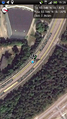
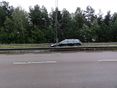
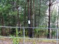
In a south bound lane on Gamla Nynäsvägen close to Haninge Golfhall in Jordbro.
Participants
- Per S
- barngroda80
- iA
Plans
We will try for a Speed Racer here today in a Volvo V70. It will be iA's first geohash. barngroda80 will try do snap a picture at the right time and Per S will drive.
Expedition
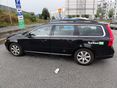
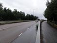
We set off in the rain about half past two. I drove and barngroda80 and iA rode in the back seat. We parked at Haninge Golfhall and iA had some milk while I walked about a hundred yards to get as close as possible to the hashpoint on the sidepath.
After another pit stop for some milk and comforting, we drove through the hashpoint heading south on Gamla Nynäsvägen. The map in the geohashing app is probably lagging a bit; I took the picture at the right place.
On the way home we did some grocery shopping and was back at about six.
Photos
Today's Citation

iA
As close as I got on the sidepath
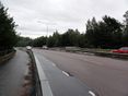
Sidepath Facing North
The Hashpoint
Sidepath Facing South
Sidepath Facing West
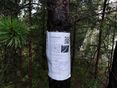
Poster

Geohasher
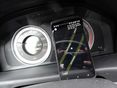
Speed Racer Achievement

Hashpoint on Google Street View
Geohash Marker


Achievements
| |||
| |||
|