Difference between revisions of "2012-11-04 52 -1"
From Geohashing
imported>Sourcerer (→Sourcerer reached a hashpoint) |
imported>FippeBot m (Location) |
||
| (6 intermediate revisions by one other user not shown) | |||
| Line 3: | Line 3: | ||
| lon=-1 | | lon=-1 | ||
| date=2012-11-04 | | date=2012-11-04 | ||
| − | | graticule_name=Birmingham | + | | graticule_name=Birmingham, UK |
| graticule_link=Birmingham, United Kingdom | | graticule_link=Birmingham, United Kingdom | ||
}} | }} | ||
| Line 9: | Line 9: | ||
== Location == | == Location == | ||
| − | In a field 42 metres off a narrow rural lane. The nearest big town was Uttoxeter. | + | 1) In a field 42 metres off a narrow rural lane. The nearest big town was Uttoxeter. |
| + | |||
| + | [[2012-11-04 52 -1]] :: [[2012-11-04 52 -0]] :: [[2012-11-04 52 0]] | ||
== Participants == | == Participants == | ||
| Line 19: | Line 21: | ||
This was attempt one of three on this day. Neil was returning from one of his beer and curry themed visits to good friends. Looking at Google maps and Street-view, the hash looked easy to reach. Indeed it was but it was located in a private field 42 metres from the little lane. Had this been obviously agricultural, Neil might have trespassed but it failed the "don't upset the locals" test. | This was attempt one of three on this day. Neil was returning from one of his beer and curry themed visits to good friends. Looking at Google maps and Street-view, the hash looked easy to reach. Indeed it was but it was located in a private field 42 metres from the little lane. Had this been obviously agricultural, Neil might have trespassed but it failed the "don't upset the locals" test. | ||
| − | + | [[File:2012-11-04 52 -1 Sourcerer.jpg]] | |
| − | {{ | + | {{Sourcerer_links |
| + | | prev = 2012-10-03 52 1 | ||
| + | | curr = 2012-11-04 52 -1 | ||
| + | | next = 2012-11-04 52 -0 | ||
| + | | date = 2012-11-04 | ||
| + | }} | ||
[[Category:Expeditions]] | [[Category:Expeditions]] | ||
| Line 27: | Line 34: | ||
[[Category:Coordinates not reached]] | [[Category:Coordinates not reached]] | ||
[[Category:Not reached - No public access]] | [[Category:Not reached - No public access]] | ||
| + | {{location|GB|ENG|STS}} | ||
Latest revision as of 06:47, 13 August 2019
| Sun 4 Nov 2012 in Birmingham, UK: 52.8422319, -1.7904151 geohashing.info google osm bing/os kml crox |
Contents
Location
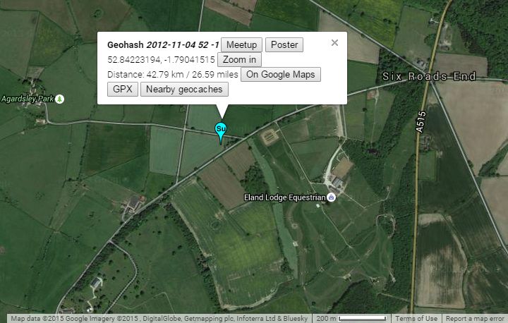
1) In a field 42 metres off a narrow rural lane. The nearest big town was Uttoxeter.
2012-11-04 52 -1 :: 2012-11-04 52 -0 :: 2012-11-04 52 0
Participants
Expedition Failed
This was attempt one of three on this day. Neil was returning from one of his beer and curry themed visits to good friends. Looking at Google maps and Street-view, the hash looked easy to reach. Indeed it was but it was located in a private field 42 metres from the little lane. Had this been obviously agricultural, Neil might have trespassed but it failed the "don't upset the locals" test.
Expeditions and Plans
| 2012-11-04 | ||
|---|---|---|
| Shepparton, Australia | Felix Dance | In a field south of Violet Town at night. |
| Gainesville, Florida | Grumpa | A stand of trees on a pasture in the middle of a bunch of private property.... |
| Tecate, Mexico | LucasBrown | A lot fenced in on three sides off Tavern Road in Alpine, CA |
| Brighton, United Kingdom | Haberdasher | just outside a commercial building in Chichester. |
| Northampton, United Kingdom | Sourcerer | 2) On a field boundary halfway between Melton Mowbray, famous for pork pies... |
| Birmingham, United Kingdom | Sourcerer | 1) In a field 42 metres off a narrow rural lane. The nearest big town was U... |
| Cambridge, United Kingdom | Sourcerer | 3) On the centre line of the A149 trunk road close to Sculthorpe Airfield. ... |
Sourcerer's Expedition Links
2012-10-03 52 1 - 2012-11-04 52 -1 - 2012-11-04 52 -0 - KML file download of Sourcerer's expeditions for use with Google Earth.
