Difference between revisions of "2012-12-26 45 -92"
imported>Swensonj (startup) |
imported>FippeBot m (Location) |
||
| (5 intermediate revisions by one other user not shown) | |||
| Line 1: | Line 1: | ||
| − | |||
| − | |||
| − | |||
| − | |||
| − | |||
| − | |||
| − | |||
| − | |||
| − | |||
| − | |||
{{meetup graticule | {{meetup graticule | ||
| lat=45 | | lat=45 | ||
| Line 15: | Line 5: | ||
}} | }} | ||
| − | |||
__NOTOC__ | __NOTOC__ | ||
== Location == | == Location == | ||
| − | + | North shoulder of Elbow Lake Road: west of Wisconsin State Highway 35, south of Siren, Wisconsin | |
== Participants == | == Participants == | ||
| − | + | [[User:Swensonj|Swensonj]] and his parents, wife, and kids | |
| − | |||
== Plans == | == Plans == | ||
| − | + | We'll catch this on the road from Superior to Minneapolis, hopefully before sunset. | |
== Expedition == | == Expedition == | ||
| − | |||
| − | + | We visited this hash on the way from Superior (WI) to Minneapolis (MN), on the way from one Christmas celebration to another. The morning was gray, but the sky cleared up nicely while we had lunch, so it was a pretty day at the hashpoint. | |
| − | + | ||
| + | We arrived about 2:45 p.m. and spent a long time doing the GPS dance. The goal was on the north shoulder of Elbow Lake Road, less than 5 feet from the road. My dad complained: had he known it was so close, he wouldn't have changed into his boots. | ||
| + | |||
| + | The dregs of my wife's tea froze almost as soon as they were outside the van. It was pretty cold: -8 C°, nearly the high temperature for the day, but still easily a [[Frozen Geohash]]. The dog had fun sniffing around for the birds that must have been nearby; the rest of my family was cheerful but cold. With Elbow Lake visible from the hashpoint, this was certainly my most photogenic location to date. | ||
== Photos == | == Photos == | ||
| Line 37: | Line 27: | ||
Image:2012-##-## ## ## Alpha.jpg | Witty Comment | Image:2012-##-## ## ## Alpha.jpg | Witty Comment | ||
--> | --> | ||
| − | <gallery perrow=" | + | <gallery perrow="4"> |
| + | Image:2012-12-26_45_-92_Proof.JPG | We were really there... | ||
| + | Image:2012-12-26_45_-92_Temp.JPG | ...and it was really cold. | ||
| + | Image:2012-12-26_45_-92_IceTea.JPG | The leftover drops of my wife's tea froze almost immediately. | ||
| + | Image:2012-12-26_45_-92_Bird.JPG | A fairly big bird had visited the hash before us. | ||
| + | Image:2012-12-26_45_-92_Grin.JPG | I had my picture taken at the hashpoint; | ||
| + | Image:2012-12-26_45_-92_Family.JPG | so did my family. | ||
| + | Image:2012-12-26_45_-92_ElbowLake.JPG | This is Elbow Lake, as seen from the hashpoint. | ||
| + | Image:2012-12-26_45_-92_Speed.JPG | We drove away through the hash at the posted speed limit: yay! | ||
</gallery> | </gallery> | ||
| Line 43: | Line 41: | ||
{{#vardefine:ribbonwidth|800px}} | {{#vardefine:ribbonwidth|800px}} | ||
<!-- Add any achievement ribbons you earned below, or remove this section --> | <!-- Add any achievement ribbons you earned below, or remove this section --> | ||
| − | + | {{land geohash | |
| − | + | | latitude = 45 | |
| − | + | | longitude = -92 | |
| − | + | | date = 2012-12-26 | |
| − | [[ | + | | name = [[User:Swensonj|Swensonj]] |
| − | + | | image = 2012-12-26_45_-92_Proof.JPG | |
| − | + | }} | |
| − | + | {{Speed racer | |
| − | [[ | + | | latitude = 45 |
| − | -- | + | | longitude = -92 |
| − | + | | date = 2012-12-26 | |
| − | + | | name = [[User:Swensonj|Swensonj]] | |
| + | | image = 2012-12-26_45_-92_Speed.JPG | ||
| + | | speed = 55 miles per hour | ||
| + | }} | ||
| + | {{Frozen Geohash | ||
| + | | latitude = 45 | ||
| + | | longitude = -92 | ||
| + | | date = 2012-12-26 | ||
| + | | name = [[User:Swensonj|Swensonj]] | ||
| + | | image = 2012-12-26_45_-92_Temp.JPG | ||
| + | | temperature = 17 °F | ||
| + | }} | ||
[[Category:Expeditions]] | [[Category:Expeditions]] | ||
| − | |||
[[Category:Expeditions with photos]] | [[Category:Expeditions with photos]] | ||
| − | |||
| − | |||
| − | |||
| − | |||
| − | |||
[[Category:Coordinates reached]] | [[Category:Coordinates reached]] | ||
| − | + | {{location|US|WI|BN}} | |
| − | |||
| − | |||
| − | |||
| − | |||
| − | |||
| − | |||
| − | |||
| − | |||
| − | |||
| − | |||
| − | |||
| − | |||
| − | |||
| − | |||
| − | |||
| − | |||
| − | |||
Latest revision as of 05:27, 6 August 2019
| Wed 26 Dec 2012 in 45,-92: 45.7411570, -92.4145576 geohashing.info google osm bing/os kml crox |
Location
North shoulder of Elbow Lake Road: west of Wisconsin State Highway 35, south of Siren, Wisconsin
Participants
Swensonj and his parents, wife, and kids
Plans
We'll catch this on the road from Superior to Minneapolis, hopefully before sunset.
Expedition
We visited this hash on the way from Superior (WI) to Minneapolis (MN), on the way from one Christmas celebration to another. The morning was gray, but the sky cleared up nicely while we had lunch, so it was a pretty day at the hashpoint.
We arrived about 2:45 p.m. and spent a long time doing the GPS dance. The goal was on the north shoulder of Elbow Lake Road, less than 5 feet from the road. My dad complained: had he known it was so close, he wouldn't have changed into his boots.
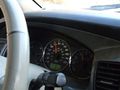
The dregs of my wife's tea froze almost as soon as they were outside the van. It was pretty cold: -8 C°, nearly the high temperature for the day, but still easily a Frozen Geohash. The dog had fun sniffing around for the birds that must have been nearby; the rest of my family was cheerful but cold. With Elbow Lake visible from the hashpoint, this was certainly my most photogenic location to date.
Photos
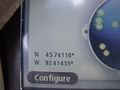
We were really there...
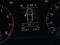
...and it was really cold.
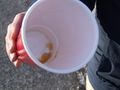
The leftover drops of my wife's tea froze almost immediately.
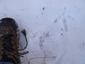
A fairly big bird had visited the hash before us.
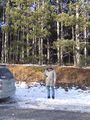
I had my picture taken at the hashpoint;
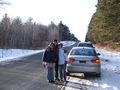
so did my family.
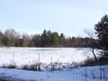
This is Elbow Lake, as seen from the hashpoint.
We drove away through the hash at the posted speed limit: yay!


Achievements
Swensonj earned the Land geohash achievement
|

