Difference between revisions of "2013-02-10 52 1"
imported>Sourcerer (→New Expedition) |
imported>MagicIan |
||
| Line 14: | Line 14: | ||
[[User:Sourcerer|Sourcerer]] | [[User:Sourcerer|Sourcerer]] | ||
| + | and | ||
| + | [[User:MagicIan|MagicIan]] - arrived separately at 11:15 | ||
== Expedition == | == Expedition == | ||
| + | [[User:Sourcerer|Sourcerer]]: | ||
A 45 km Sunday afternoon drive under leaden skies with drizzle threatening to turn to snow led to a pretty valley with a small stream (the Dentonwash) running beside the road. The Google Earth images below look summery but in real life the trees were skeletal black dripping silhouettes. A few snow drops were coming into flower promising better weather soon. Parts of the UK further west had snow today but nothing like the blanketing of north east America. | A 45 km Sunday afternoon drive under leaden skies with drizzle threatening to turn to snow led to a pretty valley with a small stream (the Dentonwash) running beside the road. The Google Earth images below look summery but in real life the trees were skeletal black dripping silhouettes. A few snow drops were coming into flower promising better weather soon. Parts of the UK further west had snow today but nothing like the blanketing of north east America. | ||
| + | |||
| + | [[User:MagicIan|MagicIan]] was daft enough to go for a 48km bike ride to the hashpoint in the weather described above! It was cold and dreary so not ideal for taking lots of photos, but still a pleasant ride. The actual hashpoint was just over the hedge, but he got within a couple of meters. | ||
| + | |||
| + | == Achievements == | ||
| + | {{Bicycle geohash | ||
| + | | latitude = 52 | ||
| + | | longitude = 1 | ||
| + | | date = 2013-02-10 | ||
| + | | name = [[User:MagicIan|MagicIan]] | ||
| + | | distance = 48.0km | ||
| + | }} | ||
== Photos == | == Photos == | ||
<gallery perrow="5"> | <gallery perrow="5"> | ||
| − | Image:2013-02-10 52 1 Sourcerer 1.jpg| | + | Image:2013-02-10 52 1 Sourcerer 1.jpg|[[User:Sourcerer|Sourcerer's]] track log in Google Earth |
| − | Image:2013-02-10_52_1_Sourcerer_2.jpg| | + | Image:2013-02-10_52_1_Sourcerer_2.jpg|[[User:Sourcerer|Sourcerer's]] zoomed in track log |
| + | Image:130210_Magician.JPG|[[User:MagicIan|MagicIan]] at the hashpoint | ||
| + | Image:130210_Droid.png|[[User:MagicIan|MagicIan]]'s phone screenshot showing his proximity of the hashpoint | ||
</gallery> | </gallery> | ||
Revision as of 19:18, 26 February 2013
| Sun 10 Feb 2013 in Norwich: 52.4474374, 1.3490729 geohashing.info google osm bing/os kml crox |
Contents
Location
A field right beside a narrow farm lane near Denton, Norfolk, UK.
Participants
Sourcerer and MagicIan - arrived separately at 11:15
Expedition
Sourcerer: A 45 km Sunday afternoon drive under leaden skies with drizzle threatening to turn to snow led to a pretty valley with a small stream (the Dentonwash) running beside the road. The Google Earth images below look summery but in real life the trees were skeletal black dripping silhouettes. A few snow drops were coming into flower promising better weather soon. Parts of the UK further west had snow today but nothing like the blanketing of north east America.
MagicIan was daft enough to go for a 48km bike ride to the hashpoint in the weather described above! It was cold and dreary so not ideal for taking lots of photos, but still a pleasant ride. The actual hashpoint was just over the hedge, but he got within a couple of meters.
Achievements
MagicIan earned the Bicycle geohash achievement
|
Photos
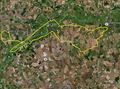
Sourcerer's track log in Google Earth
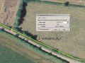
Sourcerer's zoomed in track log
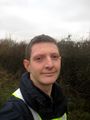
MagicIan at the hashpoint
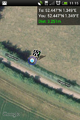
MagicIan's phone screenshot showing his proximity of the hashpoint


Other geohashing expeditions on the same day
Expeditions and Plans
| 2013-02-10 | ||
|---|---|---|
| Zürich, Switzerland | Calamus | An industrial plain at Würenlos. |
| Norwich, United Kingdom | Sourcerer, MagicIan | A field right beside a narrow farm lane near Denton, Norfolk, UK. |