imported>RocketMac |
imported>FippeBot |
| (10 intermediate revisions by 2 users not shown) |
| Line 1: |
Line 1: |
| − | So you're planning to go on a Geohashing expedition, or you've just returned from one. '''Congratulations!''' Here is a semi-standard way to create a wiki page telling the rest of the geohashing community about your expedition. The usual steps are these, and they can be done in any order:
| |
| − | *Create a link to the expedition page
| |
| − | *Edit the expedition page contents (story, gallery, categories)
| |
| − | *Upload your photos
| |
| − | More specific information below...
| |
| − |
| |
| − | Finally, don't be afraid to write up an expedition if you failed to reach the coordinates! The second-most-popular expedition page on this wiki is for a failed expedition near [[2008-05-23 42 -71|Boston]].
| |
| − |
| |
| − | __TOC__
| |
| − |
| |
| − | = The summary =
| |
| − | * Name the page correctly (YYYY-MM-DD LAT LON)
| |
| − | * Type
| |
| − | <pre>{{subst:Expedition
| |
| − | |lat = latitude of graticule
| |
| − | |lon = longitude of graticule
| |
| − | |date = date of expedition, in YYYY-MM-DD format
| |
| − | }}</pre> into the page and save.
| |
| − | * Click "edit" again and fill in the blanks
| |
| − | * Tag any images correctly
| |
| − |
| |
| − | For more details read the rest of this page :)
| |
| − |
| |
| − | = Creating and Linking the expedition page =
| |
| − |
| |
| − | Creating any expedition page is as simple as creating the link, then clicking it to edit the page. It is recommended that you start the expedition page ''before'' you go on the expedition, to enable others in your area to see that an expedition is being planned, which makes them more likely to join you. Two good places to start are your own user page, or the page for the graticule. Ideally do both, so that someone starting to geohash in your graticule can see the previous expedition. If no graticule page exists, feel free to '''[[Creating a Graticule Page|create one]]'''.
| |
| − |
| |
| − | Expedition pages are named in the following manner:
| |
| − |
| |
| − | *[[2005-05-26 37 -122]] - Date (hyphenated), followed by the graticule latitude and longitude.
| |
| − |
| |
| − | Once you have written up the report, feel free to link your most interesting picture to the report through the main page [[Main_Page#Gallery_of_Recent_Expeditions|Gallery of Recent Expeditions]]. The expedition report must be written first, so that people looking at the gallery have somewhere to go when they click.
| |
| − |
| |
| − | = Expedition contents =
| |
| − |
| |
| − | There is a brief empty template you can copy located at [[:Template:Expedition]]. Paste it into your own expedition page and start adding information. You can pre-fill this template with the most common parameters. [[:Template:Expedition|A short summary can be found here.]]
| |
| − |
| |
| − | === Meetup Graticule template ===
| |
| − | The expedition page should probably contain a meetup template. This will add a nice map with the red pointer at the spot, along with any alternate locations as blue pointers. Comments below an example:
| |
| − |
| |
| − | <pre><nowiki>
| |
| | {{meetup graticule | | {{meetup graticule |
| − | | lat=47 | + | | lat=42 |
| − | | lon=-122 | + | | lon=-87 |
| − | | date=2008-06-28 | + | | date=2013-02-06 |
| − | | graticule_name=Seattle
| + | }} |
| − | | graticule_link=Seattle, Washington}}
| |
| − | </nowiki></pre>
| |
| | | | |
| − | :The lat, lon, and date are used to display the map - all three parameters are important.
| |
| − | :The final two arguments are optional. The first specifies a "pretty" name, the second the graticule it links to.
| |
| − | :Other parameters are supported - see these [[Template:Meetup graticule|instructions]] for more information.
| |
| − |
| |
| − | === Contents ===
| |
| − | At least three sections are desirable within each expedition.
| |
| − |
| |
| − | <pre><nowiki>
| |
| | == Location == | | == Location == |
| − | </nowiki></pre>
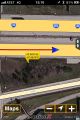
| + | The side of 894E just past the 60th St. bridge. |
| | | | |
| − | Contains a description of the location, and any alternate meetup location. Links and directions to a nearby pub fits well here also.
| + | == Participants == |
| | + | * [[User:RocketMac|RocketMac]] |
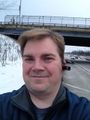
| | | | |
| − | <pre><nowiki>
| + | == Plans == |
| − | == Participants == | |
| − | </nowiki></pre>
| |
| | | | |
| − | List one person per line, linking to their user page if they have one. This section will be read by an automated bot to announce your planned expedition in the [[Geo Hashing:Current events]] section. You can add the planned expedition there manually, too.
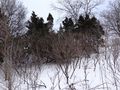
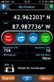
| + | I have the day off work, so I was glad to see the day's hash point was someplace I could reach and nearby. |
| | | | |
| − | <pre><nowiki>
| |
| | == Expedition == | | == Expedition == |
| − | </nowiki></pre>
| |
| | | | |
| − | Details the story of your expedition to this location. If multiple geohashers reach this point, each could create a subsection under their own username, as below.
| + | A pretty straight-forward trip. Last year I bought a [http://looxcie.com Looxcie Camera] and thought this would be a good use for it. I started my GPS tracklog and was on my way. |
| | | | |
| − | <pre><nowiki>
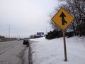
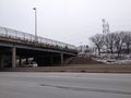
| + | The hashpoint was on the south side of the highway and just east of the 60th street bridge. I wanted to earn the [[Speed_racer_achievement|Speed Racer Achievement] so I kept my speed up as far as I could then flipped on my signal and moved to the shoulder to begin braking. |
| − | === Nukewaste ===
| |
| | | | |
| − | Caught the ferry from Bremerton across the water to Port Orchard, then took a bus ...
| + | Once parked, I got out and took some pictures. Nothing particularly stunning. Just a dreary roadside on a February day. |
| − | </nowiki></pre>
| |
| | | | |
| − | These subsections can contain words, links, pictures and galleries - see other expedition pages for many examples.
| + | == Tracklog == |
| | + | My GPS tracklog is available in [http://coldshadow.com/geohashing/2013-02-06.gpx GPX] and [http://coldshadow.com/geohashing/2013-02-06.kmz KMZ] formats. |
| | | | |
| − | === Gallery === | + | == Photos == |
| − | | + | <gallery perrow="6"> |
| − | It is always nice to include a gallery if possible. The syntax for that is here, comments below:
| + | Image:RocketMac 2013-02-06 06.jpg | The Hashpoint |
| − | | + | Image:RocketMac 2013-02-06 05.jpg | Stupid Grin |
| − | <pre><nowiki>
| + | Image:RocketMac 2013-02-06 02.jpg | The road ahead |
| − | <gallery perrow="4"> | + | Image:RocketMac 2013-02-06 03.jpg | 60th St Bridge |
| − | Image:2008_07_26_47_-122_ravine.jpg|One side of ravine... | + | Image:RocketMac 2013-02-06 01.jpg | Map |
| − | Image:2008_07_26_47_-122_ravine2.jpg|... and the other. | + | Image:RocketMac 2013-02-06 07.jpg | GPS |
| − | Image:2008_07_26_47_-122_tree.jpg|This tree leads towards the spot. | |
| − | Image:2008_07_26_47_-122_tree2.jpg|No further for me. | |
| | </gallery> | | </gallery> |
| − | </nowiki></pre>
| |
| | | | |
| − | <gallery perrow="4">
| + | == Video == |
| − | Image:2008_07_26_47_-122_ravine.jpg|One side of ravine...
| + | I took [http://coldshadow.com/geohashing/2013-02-06.mp4 this] video with my Looxie camera. |
| − | Image:2008_07_26_47_-122_ravine2.jpg|... and the other.
| |
| − | Image:2008_07_26_47_-122_tree.jpg|This tree leads towards the spot.
| |
| − | Image:2008_07_26_47_-122_tree2.jpg|No further for me.
| |
| − | </gallery>
| |
| − | :The ''perrow'' argument for gallery is optional, and specifies how many per row. If missing, the browser window width is the determining factor.
| |
| − | :Image names as uploaded are listed. After the optional vertical bar (or pipe) you can list a ''caption'' for the image, if you like.
| |
| − | :You can have multiple galleries within the expedition.
| |
| | | | |
| − | A different kind of gallery uses the same templates we use on the main page. It allows you to define image sizes and comment space.
| + | == Achievements == |
| | + | {{#vardefine:ribbonwidth|800px}} |
| | | | |
| − | <pre><nowiki>
| + | {{land geohash |
| − | {{#vardefine:gaWidth|150}} | + | | latitude = 42 |
| − | {{#vardefine:gaHeight|127}}
| + | | longitude = -87 |
| − | {{#vardefine:gaLines|2}}
| + | | date = 2013-02-06 |
| − | {{Gallery2|
| + | | name = RocketMac |
| − | {{GalleryItem | Image:2008_07_26_47_-122_ravine.jpg|One side of ravine... }}
| + | | image = |
| − | {{GalleryItem | Image:2008_07_26_47_-122_ravine2.jpg|... and the other.}}
| |
| − | {{GalleryItem | Image:2008_07_26_47_-122_tree.jpg|This tree leads towards the spot.}}
| |
| − | {{GalleryItem | Image:2008_07_26_47_-122_tree2.jpg|No further for me.}}
| |
| | }} | | }} |
| − | </nowiki></pre>
| + | {{Speed racer |
| − | | + | | latitude = 42 |
| − | {{#vardefine:gaWidth|150}} | + | | longitude = -87 |
| − | {{#vardefine:gaHeight|127}}
| + | | date = 2013-02-06 |
| − | {{#vardefine:gaLines|2}}
| + | | name = RocketMac |
| − | {{Gallery2|
| + | | image = |
| − | {{GalleryItem | Image:2008_07_26_47_-122_ravine.jpg|One side of ravine... }}
| + | | speed = 65mph |
| − | {{GalleryItem | Image:2008_07_26_47_-122_ravine2.jpg|... and the other.}}
| |
| − | {{GalleryItem | Image:2008_07_26_47_-122_tree.jpg|This tree leads towards the spot.}}
| |
| − | {{GalleryItem | Image:2008_07_26_47_-122_tree2.jpg|No further for me.}}
| |
| | }} | | }} |
| | | | |
| − | === Categories ===
| |
| − |
| |
| − | Finally, a good set of categories should be included. Was your expedition a success? Do you have photos? Was your failure because of Mother Nature, or Private Property? These categories will be helpful for various data collectors too.
| |
| − |
| |
| − | If the expedition is just in the planning stages (and some never make it past that), use:
| |
| − | <pre><nowiki>
| |
| − | [[Category:Expedition planning]]
| |
| − | </nowiki></pre>
| |
| − |
| |
| − | If the expedition happens, use one or more of the following set:
| |
| − | <pre><nowiki>
| |
| | [[Category:Expeditions]] | | [[Category:Expeditions]] |
| | [[Category:Expeditions with photos]] | | [[Category:Expeditions with photos]] |
| | [[Category:Expeditions with videos]] | | [[Category:Expeditions with videos]] |
| − | [[Category:Expedition without GPS]]
| |
| − | </nowiki></pre>
| |
| − |
| |
| − | This was a Geohashing expedition, so did a group make it to the coordinates, or not? Select one of the following:
| |
| − | <pre><nowiki>
| |
| | [[Category:Coordinates reached]] | | [[Category:Coordinates reached]] |
| − | [[Category:Coordinates not reached]]
| + | {{location|US|WI|MU}} |
| − | </nowiki></pre>
| |
| − | | |
| − | The satellite view didn't show that river or that no-trespassing sign, or the GPS dies in the woods, or you realize there is no ''way'' you are going to get there and back before dark - hey, failure happens! Select '''one''' of the following categories that best describes why. The last category is best used for XKCD meetups where the coordinates weren't the real goal.
| |
| − | <pre><nowiki>
| |
| − | [[Category:Not reached - Mother Nature]]
| |
| − | [[Category:Not reached - No public access]]
| |
| − | [[Category:Not reached - Technology]]
| |
| − | [[Category:Not reached - Time constraints]]
| |
| − | [[Category:Not reached - Did not attempt]]
| |
| − | </nowiki></pre>
| |
| − | | |
| − | = Uploading photos =
| |
| − | | |
| − | Image filename can be whatever you like, as long as it isn't already on the system. That said, we will run out of space for images with names like '''Raptor''' and '''Big Tree''' pretty soon. I prefer to create an image filename based on the date and graticule. See above for examples.
| |
| − | | |
| − | While there is no specific limit on image sizes, please use your common sense. There is no need for several-megabyte-sized photos of a tree/bush/river. Of course feel free to make exceptions for appropriate images, but remember you can generally dramatically reduce the file size without losing much detail. Reducing the file size can be done by cropping, resizing the image, or reducing the save quality of a JPG image. Consider the contents of the image to make your decision - if you are showing GPS readings, you want to make sure the result is readable!
| |
| − | | |
| − | Once the downsized pictures are ready to be posted on the wiki, click [[Special:Upload|'''Upload file''']] under '''toolbox''' in the left side menu bar. Click the '''Browse''' button and you can navigate your directories to find the file.
| |
| − | | |
| − | Finally, uploaded images can have a description (where you can optionally credit the photographer) and should have a pair of categories. These same categories will be automatically added to your expedition page (courtesy of the meetup graticule template) and help to connect your pictures to your page, graticule, and date. Type these into the '''Summary''' box before clicking '''Upload file'''.
| |
| − | | |
| − | <pre><nowiki>
| |
| − | [[Category:Meetup on 2008-07-26]]
| |
| − | [[Category:Meetup in 47 -122]]
| |
| − | </nowiki></pre>
| |
| − | | |
| − | These can be copied once, then pasted onto each photo as uploaded. They can also be added later, if you wish.
| |
| − | | |
| − | See [[:Category:Galleries by topic]] for other categories you might want to put on your photographs.
| |
| − | | |
| − | [[Category:Expeditions]]
| |
| − | [[Category:Wiki stuff]]
| |
| − | [[Category:Geohashing guide]]
| |