Difference between revisions of "2010-08-25 52 1"
imported>MagicIan m |
imported>MagicIan (→Photos) |
||
| Line 27: | Line 27: | ||
== Photos == | == Photos == | ||
| − | + | <gallery perrow="4"> | |
| + | Image:100825_reeds.JPG|Photo taken in the channels alongside Horsey Mere on the way to the hashpoint for Monday 2010-08-25, 52.445590° 1.370603° (Norwich, United Kingdom) | ||
| + | Image:100825_kayak.JPG|Photo taken in the channels alongside Horsey Mere on the way to the hashpoint for Monday 2010-08-25, 52.445590° 1.370603° (Norwich, United Kingdom) | ||
| + | Image:100825_hashpoint.JPG|Photo taken at the hashpoint for Monday 2010-08-25, 52.445590° 1.370603° (Norwich, United Kingdom) | ||
| + | </gallery> | ||
| + | |||
| + | |||
<!-- Potential categories. Please include all the ones appropriate to your expedition --> | <!-- Potential categories. Please include all the ones appropriate to your expedition --> | ||
Revision as of 21:10, 25 February 2013
Location
In wetland by Horsey Mere
| Wed 25 Aug 2010 in Norwich: 52.7488602, 1.6183410 geohashing.info google osm bing/os kml crox |
Participants
Expedition
Sourcerer (Neil) gave me the heads up on this hash on the Wednesday as it was pretty interesting. Unfortunately I had to work so was unable to get it on the 25th, but I did make it (within a few metres) on the 30th.
I drove to Horsey Windpump and launched my kayak there. Then paddled across Horsey Mere which was pretty windy. It took a couple of attempts going down different dykes to find one that would get close to the hashpoint. Some bits I was fighting through trees and reeds to make forward progress. I got out on the bank and could see the hashpoint but didn't fancy wading into a bog to touch it.
The way back was easier, and I followed the bank around Horsey Mere to avoid the worst of the waves. Total distance paddled was 3.76 miles.
Achievements
Doesn't quite qualify as a Water Geohash, despite all the water involved!
Photos
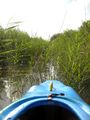
Photo taken in the channels alongside Horsey Mere on the way to the hashpoint for Monday 2010-08-25, 52.445590° 1.370603° (Norwich, United Kingdom)
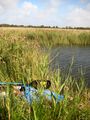
Photo taken in the channels alongside Horsey Mere on the way to the hashpoint for Monday 2010-08-25, 52.445590° 1.370603° (Norwich, United Kingdom)
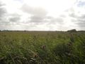
Photo taken at the hashpoint for Monday 2010-08-25, 52.445590° 1.370603° (Norwich, United Kingdom)


