Difference between revisions of "2013-03-09 52 13"
imported>Karasu ([live] My First Hash) |
imported>FippeBot m (Location) |
||
| (25 intermediate revisions by 3 users not shown) | |||
| Line 18: | Line 18: | ||
__NOTOC__ | __NOTOC__ | ||
== Location == | == Location == | ||
| − | < | + | This days hash is outskirts of Berlin near the village Zeuthen, <br />easily accesible via public transportation <br />with the nearest station being S-Bhf Wildau. |
| + | |||
| + | * Expectation: <br />The hash is located on the edge of a small forest, very close to a river | ||
| + | * Reality: <br />The hash was roughly 2m off the riverside just within the water. | ||
== Participants == | == Participants == | ||
| − | + | * [[User:Karasu|Karasu]] ([[User talk:Karasu|talk]]) | |
| − | + | ||
== Plans == | == Plans == | ||
| − | + | I just recently found out about geohashing and finally got interested in visiting a hash myself. So I waited for the weekend which brought me this easy hash, accessible via public transportation and a brief walk. | |
| + | |||
== Expedition == | == Expedition == | ||
| − | |||
| + | I took public transportation to S-Bhf Zeuthen and then continued by bus to S-Bhf Wildau. (railway under construction) My first attempt to reach the hash came to a sudden stop when I reached the edge of the forest just 600m from the hash. A friendly red sign informed me not to trespass though a heavily used trail led right past it. I felt no desire to follow the path since the warning might be in place due to a rampant presence of raptors. I then circled back and followed the main road to access the hash from the back. | ||
| + | |||
| + | After a short walk I reached a senior center that led me right to the riverside. And there I found the corresponding path again. | ||
| + | This time there were no signs put up although again the path was clearly visible. I felt like being in some kind of trespassing | ||
| + | grey zone since there were no fences to vault or anything similar. The path led me into the forest and past some shabby shacks | ||
| + | (did I just hear banjo music?) and abandoned buildings (to my luck no InGen property) followed by some balancing along a fallen | ||
| + | tree across a muddy, tiny river. I then came to realize that the hash was unreachable without getting wet. But since the HashDroid app confirmed me being within the deviation of my GPS by showing me a green distance (somewhat between 4m and 9m) I felt that this would suffice. I left the necessary evidence on the spot closest to the hash and uploaded my position with my tab. | ||
| + | |||
| + | *Proudly reached my first hash -- [[User:Karasu|Karasu]] ([[User talk:Karasu|talk]]) [http://www.openstreetmap.org/?lat=52.33064890&lon=13.64169359&zoom=16&layers=B000FTF @52.3306,13.6417] 14:52, 9 March 2013 (CET) | ||
| − | |||
== Tracklog == | == Tracklog == | ||
<!-- if your GPS device keeps a log, you may post a link here --> | <!-- if your GPS device keeps a log, you may post a link here --> | ||
| + | Had some issues with my GPS taking ages to get a satellite feed so only a short log was taken from the bus station to the hash. I see no need to post it here and am not quite sure where to do so in case I want to. So I might add it somewhen... | ||
| − | == Photos == | + | == Photos == |
| − | < | + | Pictures uploaded later on from the HashDroid app. |
| − | Image: | + | |
| − | -- | + | <gallery> |
| − | + | Image:2013-03-09_52_13_17-21-26-832.jpg | I left a sign hoping the water police that was just passing by won't mind | |
| + | Image:2013-03-09_52_13_17-26-26-852.jpg | The mayor personally informed me not to trespass... although no raptor warnings were issued | ||
| + | Image:2013-03-09_52_13_17-38-50-439.jpg | The closest thing to an adventure: a little bit of balancing as not to get your feet dirty | ||
| + | Image:2013-03-09_52_13_19-24-32-691.jpg | Panorama view of the location with the hash being the tip of ground on the left. | ||
</gallery> | </gallery> | ||
| + | |||
| + | |||
== Achievements == | == Achievements == | ||
| Line 46: | Line 63: | ||
<!-- Add any achievement ribbons you earned below, or remove this section --> | <!-- Add any achievement ribbons you earned below, or remove this section --> | ||
| + | I'm not quite sure if I should get any achievements since the exact location of the hash was in the water but I'll consider this my first hash! | ||
| − | |||
| − | |||
| − | |||
| − | |||
| − | |||
| − | |||
| − | |||
| − | |||
| − | |||
[[Category:Expeditions]] | [[Category:Expeditions]] | ||
| − | |||
[[Category:Expeditions with photos]] | [[Category:Expeditions with photos]] | ||
| − | |||
| − | |||
| − | |||
| − | |||
| − | |||
[[Category:Coordinates reached]] | [[Category:Coordinates reached]] | ||
| − | + | {{location|DE|BB|LDS}} | |
| − | |||
| − | |||
| − | |||
| − | |||
| − | |||
| − | |||
| − | |||
| − | |||
| − | |||
| − | |||
| − | |||
| − | |||
| − | |||
| − | |||
| − | |||
| − | |||
| − | |||
Latest revision as of 01:21, 14 August 2019
| Sat 9 Mar 2013 in 52,13: 52.3306481, 13.6416891 geohashing.info google osm bing/os kml crox |
Location
This days hash is outskirts of Berlin near the village Zeuthen,
easily accesible via public transportation
with the nearest station being S-Bhf Wildau.
- Expectation:
The hash is located on the edge of a small forest, very close to a river - Reality:
The hash was roughly 2m off the riverside just within the water.
Participants
Plans
I just recently found out about geohashing and finally got interested in visiting a hash myself. So I waited for the weekend which brought me this easy hash, accessible via public transportation and a brief walk.
Expedition
I took public transportation to S-Bhf Zeuthen and then continued by bus to S-Bhf Wildau. (railway under construction) My first attempt to reach the hash came to a sudden stop when I reached the edge of the forest just 600m from the hash. A friendly red sign informed me not to trespass though a heavily used trail led right past it. I felt no desire to follow the path since the warning might be in place due to a rampant presence of raptors. I then circled back and followed the main road to access the hash from the back.
After a short walk I reached a senior center that led me right to the riverside. And there I found the corresponding path again. This time there were no signs put up although again the path was clearly visible. I felt like being in some kind of trespassing grey zone since there were no fences to vault or anything similar. The path led me into the forest and past some shabby shacks (did I just hear banjo music?) and abandoned buildings (to my luck no InGen property) followed by some balancing along a fallen tree across a muddy, tiny river. I then came to realize that the hash was unreachable without getting wet. But since the HashDroid app confirmed me being within the deviation of my GPS by showing me a green distance (somewhat between 4m and 9m) I felt that this would suffice. I left the necessary evidence on the spot closest to the hash and uploaded my position with my tab.
- Proudly reached my first hash -- Karasu (talk) @52.3306,13.6417 14:52, 9 March 2013 (CET)
Tracklog
Had some issues with my GPS taking ages to get a satellite feed so only a short log was taken from the bus station to the hash. I see no need to post it here and am not quite sure where to do so in case I want to. So I might add it somewhen...
Photos
Pictures uploaded later on from the HashDroid app.
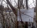
I left a sign hoping the water police that was just passing by won't mind
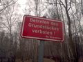
The mayor personally informed me not to trespass... although no raptor warnings were issued
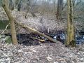
The closest thing to an adventure: a little bit of balancing as not to get your feet dirty

Panorama view of the location with the hash being the tip of ground on the left.


Achievements
I'm not quite sure if I should get any achievements since the exact location of the hash was in the water but I'll consider this my first hash!