Difference between revisions of "2013-03-26 37 -122"
imported>GeorgDerReisende (category changed from 'planned' to 'reached') |
imported>FippeBot m (Location) |
||
| (3 intermediate revisions by 2 users not shown) | |||
| Line 15: | Line 15: | ||
}} | }} | ||
| − | + | ||
__NOTOC__ | __NOTOC__ | ||
== Location == | == Location == | ||
| Line 54: | Line 54: | ||
| − | == | + | == Photos == |
| − | |||
| − | |||
| − | |||
| − | |||
| − | |||
<gallery perrow="5"> | <gallery perrow="5"> | ||
File:20130326_geohash.png| FunkyTuba's iPhone screencap | File:20130326_geohash.png| FunkyTuba's iPhone screencap | ||
| Line 67: | Line 62: | ||
== Achievements == | == Achievements == | ||
{{#vardefine:ribbonwidth|800px}} | {{#vardefine:ribbonwidth|800px}} | ||
| − | + | ||
How can you avoid speed racer? | How can you avoid speed racer? | ||
| Line 75: | Line 70: | ||
{{Speed racer | latitude = 37 | longitude = -122 | date = 2013-03-26 | name = FunkyTuba | speed = 65 mph }} | {{Speed racer | latitude = 37 | longitude = -122 | date = 2013-03-26 | name = FunkyTuba | speed = 65 mph }} | ||
| − | + | * Land geohash | |
| − | |||
| − | |||
| − | |||
| − | |||
| + | [[Category:Expeditions]] | ||
| + | [[Category:Expeditions with photos]] | ||
[[Category:Coordinates reached]] | [[Category:Coordinates reached]] | ||
| + | {{location|US|CA|SL}} | ||
Latest revision as of 01:34, 14 August 2019
| Tue 26 Mar 2013 in 37,-122: 37.3601815, -122.0628796 geohashing.info google osm bing/os kml crox |
Location
In the middle of the northbound lane of 85!
Participants
Anniepoo is headed that way later today, looking for drag alongs from Menlo Park area.
FunkyTuba already posted a GPS shot that he's passed through it on the sfsj-geohash list
Plans
Expedition
Drove down about 4:15pm, and, predictably, it being an easy hash, something had to go wrong.
For some reason my phone wouldn't pick up GPS all the way down. I did have a track recorder running, which might have been part of it.
I figure out I've gone past, I come back up to El Camino, probably passing thru it, pull off into a parking lot and sort out the phone. Finally get navigation working.
Drive back down on city streets to the exit south, come back, pass thru the hash point and snap a screen capture as I do.
Pull off onto El Camino again and grab campechana de camaron e pulpo at Chalateca
Continue on to Panera and set up laptop, where I'm writing this.
On my way to work, I went up 85 instead of 280 ... then actually went back down 85 because I saw bad traffic up on 101 :D. It was a little tricky to time the screen capture and not run into anyone, but I was able to manage it. Not recommended. Do not try this in your vehicle alone... drag a passenger along and double up your achievements.
Photos
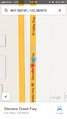
FunkyTuba's iPhone screencap

Achievements
How can you avoid speed racer?
A: (after the hash) Traffic!
FunkyTuba earned the Speed racer achievement
|
- Land geohash