Difference between revisions of "2013-05-03 39 -77"
imported>OfficeLinebacker ([live picture] Play area [http://www.openstreetmap.org/?lat=39.15879550&lon=-77.39974233&zoom=16&layers=B000FTF @39.1588,-77.3997]) |
imported>FippeBot m (Location) |
||
| (12 intermediate revisions by 3 users not shown) | |||
| Line 15: | Line 15: | ||
}} | }} | ||
| − | + | ||
__NOTOC__ | __NOTOC__ | ||
== Location == | == Location == | ||
| − | + | ||
| + | Near a water tower, gas yard, and some back yards in Poolesville, MD. May be an alien abduction spot. | ||
== Participants == | == Participants == | ||
| − | + | ||
| − | + | * [[User:OfficeLinebacker|OfficeLinebacker]] | |
| + | * Allison | ||
== Plans == | == Plans == | ||
| Line 30: | Line 32: | ||
<!-- how it all turned out. your narrative goes here. --> | <!-- how it all turned out. your narrative goes here. --> | ||
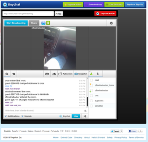
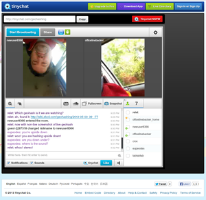
| + | So in the IRC chat room we talked about doing a live streaming geohash expedition. I managed to install the TinyChat app on my Droid and Allison's iPhone and try it. I created a tinychat and a few of our European counterparts, relet, crox, Eupeodes, decided to tune in to a tinychat room. | ||
| + | |||
| + | We gave a few live broadcasts as we drove to Poolesville, MD, about 35 mins away from my house in Rockville, MD. We parked in the parking lot of a little yard that is for Natural Gas and started walking into the woods. We ran into a mother and a daughter and made sure it was OK to walk around back there and they said yes, they were walking to their neighbor's house through the exact same area. | ||
| + | |||
| + | We came to an area in the woods which was behind some houses, but not part of their backyards. There was a big pit in the ground and some run down playhouse type equipment back there. We took our silly grin geohash pic, including the screen of Allison's iPhone with the tinychat room loaded, so everyone made it together. Relet took some screen shots. | ||
| + | |||
| + | [[File:2013-05-03_39_-77_live_tinychat.png|thumb|300px]] | ||
| + | |||
| + | [[File:2013-05-03_39_-77_double_live_stream.png|thumb|300px]] | ||
| + | |||
| + | * Screenshots from the live stream above. (this way -->) -- [[User:relet|relet]] | ||
| + | |||
| + | After the actual achievement, we had to explore the mysterious silo which we had observed on the satellite images, so we drove around to get to the silo. We think it was a water tower. We also picked up a hitchhiker, an inchworm was on Allison's leg by this point. | ||
| + | |||
| + | We concluded the broadcast out side of the silo/water tower/alien abduction sentinel and headed back home. | ||
| + | |||
| + | On the way back we saw a steep dirt road which I couldn't resist trying in my 4WD, and drove through some big mud puddles. Very satisfying. | ||
| − | + | Here's a link to the YouTube video: http://www.youtube.com/watch?v=qG0rCMFzZxc | |
| − | |||
| − | |||
| − | |||
== Tracklog == | == Tracklog == | ||
| Line 48: | Line 64: | ||
Image:2013-05-03_39_-77_15-58-08-789.jpg | Play area [http://www.openstreetmap.org/?lat=39.15879550&lon=-77.39974233&zoom=16&layers=B000FTF @39.1588,-77.3997] | Image:2013-05-03_39_-77_15-58-08-789.jpg | Play area [http://www.openstreetmap.org/?lat=39.15879550&lon=-77.39974233&zoom=16&layers=B000FTF @39.1588,-77.3997] | ||
| + | |||
| + | Image:2013-05-03_39_-77_16-38-22-597.jpg | An old barn on the way [http://www.openstreetmap.org/?lat=39.15881432&lon=-77.38576528&zoom=16&layers=B000FTF @39.1588,-77.3858] | ||
| + | |||
| + | Image:2013-05-03_39_-77_16-39-32-557.jpg | On the way back we found a muddy trail to drive through [http://www.openstreetmap.org/?lat=39.15882820&lon=-77.38567383&zoom=16&layers=B000FTF @39.1588,-77.3857] | ||
</gallery> | </gallery> | ||
| Line 54: | Line 74: | ||
<!-- Add any achievement ribbons you earned below, or remove this section --> | <!-- Add any achievement ribbons you earned below, or remove this section --> | ||
| + | * Land Geohash | ||
| − | |||
| − | |||
| − | |||
| − | + | [[Category:Expeditions]] | |
| − | |||
| − | [[Category: | ||
| − | |||
| − | |||
| − | |||
| − | |||
[[Category:Expeditions with photos]] | [[Category:Expeditions with photos]] | ||
| − | |||
| − | |||
| − | |||
| − | |||
| − | |||
[[Category:Coordinates reached]] | [[Category:Coordinates reached]] | ||
| − | + | {{location|US|MD|MO}} | |
| − | |||
| − | |||
| − | |||
| − | |||
| − | |||
| − | |||
| − | |||
| − | |||
| − | |||
| − | |||
| − | |||
| − | |||
| − | |||
| − | |||
| − | |||
| − | |||
| − | |||
Latest revision as of 02:10, 14 August 2019
| Fri 3 May 2013 in 39,-77: 39.1587552, -77.3997228 geohashing.info google osm bing/os kml crox |
Location
Near a water tower, gas yard, and some back yards in Poolesville, MD. May be an alien abduction spot.
Participants
- OfficeLinebacker
- Allison
Plans
Expedition
So in the IRC chat room we talked about doing a live streaming geohash expedition. I managed to install the TinyChat app on my Droid and Allison's iPhone and try it. I created a tinychat and a few of our European counterparts, relet, crox, Eupeodes, decided to tune in to a tinychat room.
We gave a few live broadcasts as we drove to Poolesville, MD, about 35 mins away from my house in Rockville, MD. We parked in the parking lot of a little yard that is for Natural Gas and started walking into the woods. We ran into a mother and a daughter and made sure it was OK to walk around back there and they said yes, they were walking to their neighbor's house through the exact same area.
We came to an area in the woods which was behind some houses, but not part of their backyards. There was a big pit in the ground and some run down playhouse type equipment back there. We took our silly grin geohash pic, including the screen of Allison's iPhone with the tinychat room loaded, so everyone made it together. Relet took some screen shots.
- Screenshots from the live stream above. (this way -->) -- relet
After the actual achievement, we had to explore the mysterious silo which we had observed on the satellite images, so we drove around to get to the silo. We think it was a water tower. We also picked up a hitchhiker, an inchworm was on Allison's leg by this point.
We concluded the broadcast out side of the silo/water tower/alien abduction sentinel and headed back home.
On the way back we saw a steep dirt road which I couldn't resist trying in my 4WD, and drove through some big mud puddles. Very satisfying.
Here's a link to the YouTube video: http://www.youtube.com/watch?v=qG0rCMFzZxc
Tracklog
Photos
We're here! @39.1588,-77.3998
Play area @39.1588,-77.3997
An old barn on the way @39.1588,-77.3858
On the way back we found a muddy trail to drive through @39.1588,-77.3857
Achievements
- Land Geohash


