Difference between revisions of "2013-05-20 42 -90"
From Geohashing
imported>Swensonj (template) |
imported>FippeBot m (Location) |
||
| (3 intermediate revisions by one other user not shown) | |||
| Line 1: | Line 1: | ||
| − | |||
| − | |||
| − | |||
| − | |||
| − | |||
| − | |||
| − | |||
| − | |||
| − | |||
| − | |||
{{meetup graticule | {{meetup graticule | ||
| lat=42 | | lat=42 | ||
| Line 15: | Line 5: | ||
}} | }} | ||
| − | |||
__NOTOC__ | __NOTOC__ | ||
== Location == | == Location == | ||
| − | + | Circle Road, north of Lancaster, Wisconsin | |
== Participants == | == Participants == | ||
| − | + | [[User:Swensonj|SwensonJ]] ([[User talk:Swensonj|talk]]) | |
| − | |||
== Plans == | == Plans == | ||
| − | + | A quick stop is planned, sometime in the late morning. | |
| + | |||
== Expedition == | == Expedition == | ||
| − | + | [[Image:2013-05-20 42 -90 Track.PNG|thumb|310px|Tracklog image]] | |
| + | |||
| + | (This is the first of consecutive geohashes: see [[2013-05-21_42_-89|next]].) | ||
| + | |||
| + | We left Platteville about 10:30 a.m. and had an easy drive to the hashpoint, which was on the north shoulder of Circle Road, a few miles north of Lancaster, Wisconsin. | ||
| − | + | The sky was completely cloudless when we left home; a few puffy white clouds drifted in as we travelled, but it was a beautiful day to be out. We had a quick picnic in the shade of the van's tailgate, then headed back in time to meet my daughter's class, on a picnic of their own. | |
| − | |||
== Photos == | == Photos == | ||
<!-- Insert pictures between the gallery tags using the following format: | <!-- Insert pictures between the gallery tags using the following format: | ||
| − | |||
--> | --> | ||
| − | <gallery perrow=" | + | <gallery perrow="4"> |
| + | Image:2013-05-20 42 -90 Proof.jpg | We were there... | ||
| + | Image:2013-05-20 42 -90 Grin.jpg | and we were happy. | ||
| + | Image:2013-05-20 42 -90 Road.jpg | Circle Road | ||
| + | Image:2013-05-20 42 -90 Picnic.jpg | A quick picnic | ||
| + | Image:2013-05-20 42 -90 Field.jpg | View from hash: south | ||
| + | Image:2013-05-20 42 -90 Farm.jpg | View from hash: north | ||
| + | Image:2013-05-20 42 -90 Hill.jpg | View north from Circle Road | ||
</gallery> | </gallery> | ||
== Achievements == | == Achievements == | ||
{{#vardefine:ribbonwidth|800px}} | {{#vardefine:ribbonwidth|800px}} | ||
| − | + | {{land geohash | |
| − | + | | latitude = 42 | |
| + | | longitude = -90 | ||
| + | | date = 2013-05-20 | ||
| + | | name = SwensonJ | ||
| + | | image = 2013-05-20 42 -90 Proof.jpg | ||
| + | }} | ||
| − | |||
| − | |||
| − | |||
| − | |||
| − | |||
| − | |||
| − | |||
| − | |||
| − | |||
| − | |||
[[Category:Expeditions]] | [[Category:Expeditions]] | ||
| − | |||
[[Category:Expeditions with photos]] | [[Category:Expeditions with photos]] | ||
| − | |||
| − | |||
| − | |||
| − | |||
| − | |||
[[Category:Coordinates reached]] | [[Category:Coordinates reached]] | ||
| − | + | {{location|US|WI|GA}} | |
| − | |||
| − | |||
| − | |||
| − | |||
| − | |||
| − | |||
| − | |||
| − | |||
| − | |||
| − | |||
| − | |||
| − | |||
| − | |||
| − | |||
| − | |||
| − | |||
| − | |||
Latest revision as of 02:24, 14 August 2019
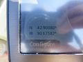
| Mon 20 May 2013 in 42,-90: 42.9008058, -90.6758237 geohashing.info google osm bing/os kml crox |
Location
Circle Road, north of Lancaster, Wisconsin
Participants
Plans
A quick stop is planned, sometime in the late morning.
Expedition

(This is the first of consecutive geohashes: see next.)
We left Platteville about 10:30 a.m. and had an easy drive to the hashpoint, which was on the north shoulder of Circle Road, a few miles north of Lancaster, Wisconsin.
The sky was completely cloudless when we left home; a few puffy white clouds drifted in as we travelled, but it was a beautiful day to be out. We had a quick picnic in the shade of the van's tailgate, then headed back in time to meet my daughter's class, on a picnic of their own.
Photos
We were there...
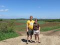
and we were happy.
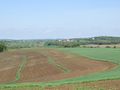
Circle Road
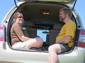
A quick picnic
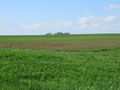
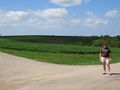
View from hash: south
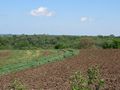
View from hash: north
View north from Circle Road


Achievements
SwensonJ earned the Land geohash achievement
|