Difference between revisions of "2013-04-26 52 0"
imported>Benjw (deploy expedition template) |
imported>Benjw (add expedition report) |
||
| Line 1: | Line 1: | ||
| − | + | [[Image:2013-04-26 52 0 busy road.jpg|thumb|left]] | |
| − | |||
| − | |||
| − | [[Image: | ||
| − | |||
| − | |||
| − | |||
| − | |||
| − | |||
| − | |||
{{meetup graticule | {{meetup graticule | ||
| − | | lat= | + | | lat=52 |
| lon=0 | | lon=0 | ||
| date=2013-04-26 | | date=2013-04-26 | ||
| + | | graticule_name=Cambridge, UK | ||
| + | | graticule_link=Cambridge, United Kingdom | ||
}} | }} | ||
| − | + | {{User:Benjw/multihash|2013-04-26 52 -0|2013-04-26 52 0}} | |
| − | |||
| − | |||
== Location == | == Location == | ||
| − | + | On the verge of the A14's east-bound carriageway, just at the bottom of the Histon slip-road north of Cambridge. | |
== Participants == | == Participants == | ||
| − | + | * [[User:Benjw|Benjw]] | |
| − | |||
== Plans == | == Plans == | ||
| − | + | Today was a doubly lucky location, as due to the prime meridian, this hashpoint and its neighbour to the west, [[2013-04-26 52 -0]], were only 14.6 km apart, as the crow flies. Ben resolved to make it to both hashpoints during the afternoon. On looking a bit closer, he also discovered that the [[2013-04-26 52 0|52,0]] hashpoint was on the A14 east-west trunk route, and the [[2013-04-26 52 -0|52,-0]] hashpoint was on the A1198 minor road, which joins the A428 at a roundabout just south of the hashpoint. The A428 then turns into the A14 as it approaches Cambridge. This meant that the hashes were a mere 15.8 km apart, and were separated almost entirely by a dual-carriageway with a speed limit of 70 mph (112 kph). This would be an excellent chance to set a new record for Ben's quickest double-hash, currently set at "under 20 minutes" with [[2012-09-25 52 0]] and [[2012-09-25 52 -0]]. | |
== Expedition == | == Expedition == | ||
| − | + | Having set a stopwatch running at the [[2013-04-26 52 -0|previous hashpoint]], Ben jogged back to the car and set off for the Cambridge graticule. His previous record was "under 20 minutes", but with only ten miles of dual carriageway separating today's hashpoints, that record should be easily broken. And indeed, as it was not yet rush-hour, there was traffic, but not too much of it. Approaching the hashpoint, Ben pulled off onto the slip-road to the nearby junction, and then onto the grass verge. He had overshot the hashpoint by about five metres, but that was easily rectified by getting out the car. Photos were quickly taken, and the elapsed time from hashpoint to hashpoint was recorded as 12 minutes and 40 seconds, a record which will be quite hard to beat! | |
| − | + | To finish off a totally-convenient double expedition, the sliproad Ben had parked on was the one he needed to take anyway to get back to his house. This was achieved a mere six minutes later, as this hashpoint had been the (successful) hash closest to home so far. Still a bit too far away for the couch potato award, though. | |
| − | |||
== Photos == | == Photos == | ||
| − | |||
| − | |||
| − | |||
<gallery perrow="5"> | <gallery perrow="5"> | ||
| + | Image:2013-04-26 52 0 proof.jpg | Hashpoint reached ... | ||
| + | Image:2013-04-26 52 0 stopwatch.jpg | ... and I made it in record time. | ||
| + | Image:2013-04-26 52 0 happy hasher.jpg | A happy but slightly squinting hasher. | ||
| + | Image:2013-04-26 52 0 busy road.jpg | Rush hour was approaching. | ||
</gallery> | </gallery> | ||
== Achievements == | == Achievements == | ||
{{#vardefine:ribbonwidth|800px}} | {{#vardefine:ribbonwidth|800px}} | ||
| − | + | {{land geohash | |
| + | | latitude = 52 | ||
| + | | longitude = 0 | ||
| + | | date = 2013-04-26 | ||
| + | | name = [[User:Benjw|Benjw]] | ||
| + | | image = 2013-04-26 52 0 busy road.jpg | ||
| + | }} | ||
| + | {{multihash2 | ||
| + | | date = 2013-04-26 | ||
| + | | count = 2 | ||
| + | | name = [[User:Benjw|Benjw]] | ||
| + | | image = 2013-04-26 52 -0 speed racer.jpg | ||
| + | }} | ||
| − | |||
| − | |||
| − | |||
| − | |||
| − | |||
| − | |||
| − | |||
| − | |||
| − | |||
| − | |||
| − | |||
[[Category:Expeditions]] | [[Category:Expeditions]] | ||
| − | |||
[[Category:Expeditions with photos]] | [[Category:Expeditions with photos]] | ||
| − | |||
| − | |||
| − | |||
| − | |||
| − | |||
[[Category:Coordinates reached]] | [[Category:Coordinates reached]] | ||
| − | |||
| − | |||
| − | |||
| − | |||
| − | |||
| − | |||
| − | |||
| − | |||
| − | |||
| − | |||
| − | |||
| − | |||
| − | |||
| − | |||
| − | |||
| − | |||
| − | |||
| − | |||
Revision as of 15:16, 17 June 2013

| Fri 26 Apr 2013 in Cambridge, UK: 52.2348081, 0.1075013 geohashing.info google osm bing/os kml crox |
| This expedition was part of a multihash by Benjw. For the other parts, see: | |||||
|---|---|---|---|---|---|
| 2013-04-26 52 -0 | 2013-04-26 52 0 | ||||
Location
On the verge of the A14's east-bound carriageway, just at the bottom of the Histon slip-road north of Cambridge.
Participants
Plans
Today was a doubly lucky location, as due to the prime meridian, this hashpoint and its neighbour to the west, 2013-04-26 52 -0, were only 14.6 km apart, as the crow flies. Ben resolved to make it to both hashpoints during the afternoon. On looking a bit closer, he also discovered that the 52,0 hashpoint was on the A14 east-west trunk route, and the 52,-0 hashpoint was on the A1198 minor road, which joins the A428 at a roundabout just south of the hashpoint. The A428 then turns into the A14 as it approaches Cambridge. This meant that the hashes were a mere 15.8 km apart, and were separated almost entirely by a dual-carriageway with a speed limit of 70 mph (112 kph). This would be an excellent chance to set a new record for Ben's quickest double-hash, currently set at "under 20 minutes" with 2012-09-25 52 0 and 2012-09-25 52 -0.
Expedition
Having set a stopwatch running at the previous hashpoint, Ben jogged back to the car and set off for the Cambridge graticule. His previous record was "under 20 minutes", but with only ten miles of dual carriageway separating today's hashpoints, that record should be easily broken. And indeed, as it was not yet rush-hour, there was traffic, but not too much of it. Approaching the hashpoint, Ben pulled off onto the slip-road to the nearby junction, and then onto the grass verge. He had overshot the hashpoint by about five metres, but that was easily rectified by getting out the car. Photos were quickly taken, and the elapsed time from hashpoint to hashpoint was recorded as 12 minutes and 40 seconds, a record which will be quite hard to beat!
To finish off a totally-convenient double expedition, the sliproad Ben had parked on was the one he needed to take anyway to get back to his house. This was achieved a mere six minutes later, as this hashpoint had been the (successful) hash closest to home so far. Still a bit too far away for the couch potato award, though.
Photos
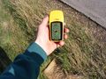
Hashpoint reached ...
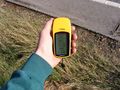
... and I made it in record time.
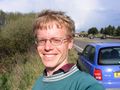
A happy but slightly squinting hasher.
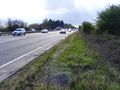
Rush hour was approaching.


Achievements
Benjw earned the Land geohash achievement
|
Benjw earned the Multihash Achievement
|