Difference between revisions of "2013-03-03 52 0"
imported>Benjw (deploy expedition template) |
imported>Benjw (expedition report) |
||
| Line 1: | Line 1: | ||
| − | + | [[Image:2013-03-03 52 0 sunset.jpg|thumb|left]] | |
| − | |||
| − | |||
| − | [[Image: | ||
| − | |||
| − | |||
| − | |||
| − | |||
| − | |||
| − | |||
{{meetup graticule | {{meetup graticule | ||
| lat=52 | | lat=52 | ||
| lon=0 | | lon=0 | ||
| date=2013-03-03 | | date=2013-03-03 | ||
| + | | graticule_name=Cambridge, UK | ||
| + | | graticule_link=Cambridge, United Kingdom | ||
}} | }} | ||
| − | |||
| − | |||
| − | |||
== Location == | == Location == | ||
| − | + | Just off a track between fields, in the middle of not very much between Royston and Saffron Walden. | |
== Participants == | == Participants == | ||
| − | + | * [[User:Benjw|Benjw]] | |
| − | |||
| − | == | + | == Expedition == |
| − | + | Today's hash looked nice and accessible, but was a reasonable distance from home and Ben didn't have much of the day free, so plans were initially put on hold. However, then he noticed that nearby were several rather old geocaches, which would be fun to collect. So the expedition was back on, albeit without much in the way of planning or a fixed time. He eventually managed to leave home at about 4:30pm. | |
| − | + | Ben drove from Cambridge to Royston on main roads, then turned off onto some more interesting and much smaller rural lanes. He spent a pleasant hour or so pottering around some of the nearby villages and finding caches, before the fading light made caching rather too difficult. Hashpoints, however, are rather easier to find in the dark. This one was simple enough -- park in the gateway into the field containing the hash, walk up along the track between the field and its neighbour, then step off the track for the last two metres or so. Photos were taken, though required a little image processing to be visible. The flash was used for the GPS photo, but was a bit useless for the rest as none of the background could be seen. | |
| − | |||
| − | + | After that Ben turned for home, with one last geocache on the way. It was a nice trip out, and a nice way to end the weekend. | |
| − | |||
| − | == | + | == Photographic documentation == |
| − | |||
| − | |||
| − | |||
<gallery perrow="5"> | <gallery perrow="5"> | ||
| + | Image:2013-03-03 52 0 proof.jpg | Proof of hash. | ||
| + | Image:2013-03-03 52 0 ben in the dark.jpg | Ben at the hashpoint. | ||
| + | Image:2013-03-03 52 0 field in the dark.jpg | Looking east. | ||
| + | Image:2013-03-03 52 0 sunset.jpg | Looking west. | ||
</gallery> | </gallery> | ||
| − | == | + | == Shiny ribbons earned == |
{{#vardefine:ribbonwidth|800px}} | {{#vardefine:ribbonwidth|800px}} | ||
| − | + | {{land geohash | |
| + | | latitude = 52 | ||
| + | | longitude = 0 | ||
| + | | date = 2013-03-03 | ||
| + | | name = [[User:Benjw|Benjw]] | ||
| + | | image = 2013-03-03 52 0 ben in the dark.jpg | ||
| + | }} | ||
| − | |||
| − | |||
| − | |||
| − | |||
| − | |||
| − | |||
| − | |||
| − | |||
| − | |||
| − | |||
| − | |||
[[Category:Expeditions]] | [[Category:Expeditions]] | ||
| − | |||
[[Category:Expeditions with photos]] | [[Category:Expeditions with photos]] | ||
| − | |||
| − | |||
| − | |||
| − | |||
| − | |||
[[Category:Coordinates reached]] | [[Category:Coordinates reached]] | ||
| − | |||
| − | |||
| − | |||
| − | |||
| − | |||
| − | |||
| − | |||
| − | |||
| − | |||
| − | |||
| − | |||
| − | |||
| − | |||
| − | |||
| − | |||
| − | |||
| − | |||
| − | |||
Revision as of 13:33, 18 June 2013

| Sun 3 Mar 2013 in Cambridge, UK: 52.0160004, 0.1443803 geohashing.info google osm bing/os kml crox |
Location
Just off a track between fields, in the middle of not very much between Royston and Saffron Walden.
Participants
Expedition
Today's hash looked nice and accessible, but was a reasonable distance from home and Ben didn't have much of the day free, so plans were initially put on hold. However, then he noticed that nearby were several rather old geocaches, which would be fun to collect. So the expedition was back on, albeit without much in the way of planning or a fixed time. He eventually managed to leave home at about 4:30pm.
Ben drove from Cambridge to Royston on main roads, then turned off onto some more interesting and much smaller rural lanes. He spent a pleasant hour or so pottering around some of the nearby villages and finding caches, before the fading light made caching rather too difficult. Hashpoints, however, are rather easier to find in the dark. This one was simple enough -- park in the gateway into the field containing the hash, walk up along the track between the field and its neighbour, then step off the track for the last two metres or so. Photos were taken, though required a little image processing to be visible. The flash was used for the GPS photo, but was a bit useless for the rest as none of the background could be seen.
After that Ben turned for home, with one last geocache on the way. It was a nice trip out, and a nice way to end the weekend.
Photographic documentation
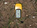
Proof of hash.
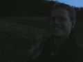
Ben at the hashpoint.
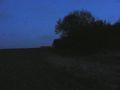
Looking east.
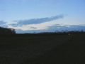
Looking west.


Shiny ribbons earned
Benjw earned the Land geohash achievement
|