Difference between revisions of "2013-07-06 52 9"
imported>GeorgDerReisende (Created page with "{{subst:Expedition |lat = 52 |lon = 9 |date = 2013-07-06 }}") |
imported>FippeBot m (Location) |
||
| (3 intermediate revisions by 2 users not shown) | |||
| Line 18: | Line 18: | ||
__NOTOC__ | __NOTOC__ | ||
== Location == | == Location == | ||
| − | + | The hash lies in the middle of the river Weser between the villages Tündern and Ohr. | |
== Participants == | == Participants == | ||
| − | + | [[User:GeorgDerReisende|GeorgDerReisende]] | |
| − | |||
== Plans == | == Plans == | ||
| − | + | [[User:GeorgDerReisende|GeorgDerReisende]] will hitchhike to Hameln and take a ship for a round-tour from there to Emmerthal and back. | |
| + | |||
| + | One line leaves Hameln at 15:00 for one hour, but is doesn't go near to that place, because it will turn at Ohr. The best possibility is to take the round-tour, which leaves Hameln at 16:00 for one hour from Am Stockhof, it will cost 7 Euros. | ||
| + | |||
| + | Another ship goes from Emmerthal to Hameln at 18:15. | ||
== Expedition == | == Expedition == | ||
| − | + | [[User:GeorgDerReisende|GeorgDerReisende]] hitchhiked from Kassel to Hameln via Göttingen, Hoheneggelsen and Hildesheim. He leaved Kassel at 9 a.m. and arrived in Hameln at 13:40. The ship costs now 9 Euros. He made the round-trip and passed the meetup-point twice. | |
== Tracklog == | == Tracklog == | ||
| Line 38: | Line 41: | ||
--> | --> | ||
<gallery perrow="5"> | <gallery perrow="5"> | ||
| + | Image:2013-07-06 52 9 GeorgDerReisende 6252.jpg | the ship | ||
| + | Image:2013-07-06 52 9 GeorgDerReisende 6257.jpg | meetup location, very near | ||
| + | Image:2013-07-06 52 9 GeorgDerReisende 6259.jpg | the village of Tündern | ||
| + | Image:2013-07-06 52 9 GeorgDerReisende 6260.jpg | on the left bank the village Ohr | ||
| + | Image:2013-07-06 52 9 GeorgDerReisende 6262.jpg | an old farmhouse in Tündern | ||
| + | Image:2013-07-06 52 9 GeorgDerReisende 6264.jpg | an old windmill in Tündern | ||
| + | Image:2013-07-06 52 9 GeorgDerReisende 6265.jpg | blind passenger | ||
| + | Image:2013-07-06 52 9 GeorgDerReisende 6278.jpg | behind the bridges of Emmerthal the nuclear power station Grohnde | ||
| + | Image:2013-07-06 52 9 GeorgDerReisende 6288.jpg | near enough? | ||
| + | Image:2013-07-06 52 9 GeorgDerReisende 6289.jpg | that's me | ||
| + | Image:2013-07-06 52 9 GeorgDerReisende 6290.jpg | some nature | ||
| + | Image:2013-07-06 52 9 GeorgDerReisende 6304.jpg | the city of Hameln seen from the river | ||
</gallery> | </gallery> | ||
| Line 44: | Line 59: | ||
<!-- Add any achievement ribbons you earned below, or remove this section --> | <!-- Add any achievement ribbons you earned below, or remove this section --> | ||
| + | {{water geohash | ||
| − | + | | latitude = 52 | |
| − | + | | longitude = 9 | |
| − | + | | date = 2013-07-06 | |
| + | | name = GeorgDerReisende | ||
| + | | vehicle = ship | ||
| + | |||
| + | }} | ||
| + | |||
| + | {{Thumbs Up | ||
| + | |||
| + | | latitude = 52 | ||
| + | | longitude = 9 | ||
| + | | date = 2013-07-06 | ||
| + | | name = GeorgDerReisende | ||
| + | |||
| + | }} | ||
<!-- Potential categories. Please include all the ones appropriate to your expedition --> | <!-- Potential categories. Please include all the ones appropriate to your expedition --> | ||
| − | |||
| − | |||
| − | |||
| − | |||
[[Category:Expeditions]] | [[Category:Expeditions]] | ||
| − | |||
[[Category:Expeditions with photos]] | [[Category:Expeditions with photos]] | ||
| − | |||
| − | |||
| − | |||
| − | |||
[[Category:Coordinates reached]] | [[Category:Coordinates reached]] | ||
| − | + | {{location|DE|NI|HM}} | |
| − | |||
| − | |||
| − | |||
| − | |||
| − | |||
| − | |||
| − | |||
| − | |||
| − | |||
| − | |||
| − | |||
| − | |||
| − | |||
| − | |||
| − | |||
| − | |||
| − | |||
Latest revision as of 03:03, 14 August 2019
| Sat 6 Jul 2013 in 52,9: 52.0623966, 9.3639936 geohashing.info google osm bing/os kml crox |
Location
The hash lies in the middle of the river Weser between the villages Tündern and Ohr.
Participants
Plans
GeorgDerReisende will hitchhike to Hameln and take a ship for a round-tour from there to Emmerthal and back.
One line leaves Hameln at 15:00 for one hour, but is doesn't go near to that place, because it will turn at Ohr. The best possibility is to take the round-tour, which leaves Hameln at 16:00 for one hour from Am Stockhof, it will cost 7 Euros.
Another ship goes from Emmerthal to Hameln at 18:15.
Expedition
GeorgDerReisende hitchhiked from Kassel to Hameln via Göttingen, Hoheneggelsen and Hildesheim. He leaved Kassel at 9 a.m. and arrived in Hameln at 13:40. The ship costs now 9 Euros. He made the round-trip and passed the meetup-point twice.
Tracklog
Photos
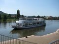
the ship

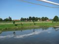
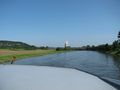
meetup location, very near
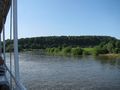
the village of Tündern
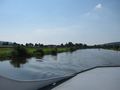
on the left bank the village Ohr
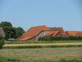
an old farmhouse in Tündern
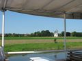
an old windmill in Tündern

blind passenger
behind the bridges of Emmerthal the nuclear power station Grohnde
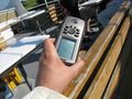
near enough?
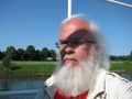
that's me
some nature
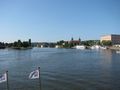
the city of Hameln seen from the river


Achievements
GeorgDerReisende earned the Water geohash achievement
|
GeorgDerReisende earned the Thumbs Up Geohash Achievement
|