Difference between revisions of "2013-08-03 43 -116"
imported>Ojones (→Participants) |
imported>Eldin (add expedition details.) |
||
| Line 1: | Line 1: | ||
| − | |||
| − | |||
| − | |||
| − | |||
| − | |||
| − | |||
| − | |||
| − | |||
| − | |||
| − | |||
{{meetup graticule | {{meetup graticule | ||
| lat=43 | | lat=43 | ||
| Line 15: | Line 5: | ||
}} | }} | ||
| − | |||
__NOTOC__ | __NOTOC__ | ||
| Line 29: | Line 18: | ||
== Expedition == | == Expedition == | ||
| − | + | [[User:Eldin|Eldin]] reached the point a little before noon, and drove through at 40mph for the [[Speed racer achievement]]. He then stopped about 800ft down the road and walked back to the point to place a marker and take pictures. After placing the marker, while getting ready to take pictures, a passing car slowed down and the driver waved. The car then proceeded to turn around and stop near the hashpoint. The driver turned out to be [[User:Ojones|Ojones]] and his family. I introduced myself, and we talked a bit about geohashing, ourselves, and the local area. Pictures were taken. And then we went on our separate ways. It was good to finally meet another geohasher while out geohashing, and good to see another geohasher appearing in the local graticule. | |
| − | |||
| − | |||
== Photos == | == Photos == | ||
| − | |||
| − | |||
| − | |||
<gallery perrow="5"> | <gallery perrow="5"> | ||
| + | File:2013-08-03 43 -116 proof.jpg | Proof that we were at the right place. | ||
| + | File:2013-08-03_43_-116_point.jpg | The actual point was about the center of the near lane. | ||
| + | File:2013-08-03_43_-116_OJones_and_family.jpg | [[User:Ojones|Ojones]] and his family were there. | ||
| + | File:2013-08-03 43 -116 Eldin.jpg | So was [[User:Eldin|Eldin]] | ||
| + | File:2013-08-03 43 -116 speed racer 1.jpg | Approaching the point at the speed limit. | ||
| + | File:2013-08-03 43 -116 speed racer 2.jpg | Just past the point, still at the speed limit. | ||
</gallery> | </gallery> | ||
== Achievements == | == Achievements == | ||
{{#vardefine:ribbonwidth|800px}} | {{#vardefine:ribbonwidth|800px}} | ||
| − | + | {{Speed racer | latitude = 43 | longitude = -116 | date = 2013-08-03 | name = [[User:Eldin|Eldin]] | speed = 40 MPH}} | |
| − | + | {{Meet-up | latitude = 43 | longitude = -116 | date = 2013-08-03 | name = [[User:Eldin|Eldin]] | other = [[User:Ojones|Ojones]]}} | |
| − | + | {{Meet-up | latitude = 43 | longitude = -116 | date = 2013-08-03 | name = [[User:Ojones|Ojones]] | other = [[User:Eldin|Eldin]]}} | |
| − | |||
| − | [[ | ||
| − | |||
| − | |||
| − | |||
| − | [[ | ||
| − | -- | ||
| − | |||
| − | |||
[[Category:Expeditions]] | [[Category:Expeditions]] | ||
| − | |||
[[Category:Expeditions with photos]] | [[Category:Expeditions with photos]] | ||
| − | |||
| − | |||
| − | |||
| − | |||
| − | |||
[[Category:Coordinates reached]] | [[Category:Coordinates reached]] | ||
| − | |||
| − | |||
| − | |||
| − | |||
| − | |||
| − | |||
| − | |||
| − | |||
| − | |||
| − | |||
| − | |||
| − | |||
| − | |||
| − | |||
| − | |||
| − | |||
| − | |||
| − | |||
Revision as of 21:10, 3 August 2013
| Sat 3 Aug 2013 in 43,-116: 43.7169253, -116.3540812 geohashing.info google osm bing/os kml crox |
Location
In the southbound lane of Eagle Rd. between Floating Feather Rd. and Beacon Light Rd.
Participants
Plans
To drive through the hash at about noon, then stop to take pictures and see if anyone else makes it.
Expedition
Eldin reached the point a little before noon, and drove through at 40mph for the Speed racer achievement. He then stopped about 800ft down the road and walked back to the point to place a marker and take pictures. After placing the marker, while getting ready to take pictures, a passing car slowed down and the driver waved. The car then proceeded to turn around and stop near the hashpoint. The driver turned out to be Ojones and his family. I introduced myself, and we talked a bit about geohashing, ourselves, and the local area. Pictures were taken. And then we went on our separate ways. It was good to finally meet another geohasher while out geohashing, and good to see another geohasher appearing in the local graticule.
Photos
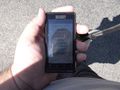
Proof that we were at the right place.
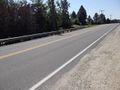
The actual point was about the center of the near lane.
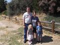
Ojones and his family were there.
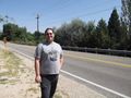
So was Eldin
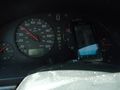
Approaching the point at the speed limit.
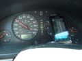
Just past the point, still at the speed limit.


Achievements

Eldin earned the Meet-up achievement
|
Ojones earned the Meet-up achievement
|