Difference between revisions of "2013-08-23 45 -122"
imported>Frogman (→Photos) |
imported>Frogman (→Achievements) |
||
| Line 50: | Line 50: | ||
<!-- Add any achievement ribbons you earned below, or remove this section --> | <!-- Add any achievement ribbons you earned below, or remove this section --> | ||
| + | [[Category:Expeditions]] | ||
| − | |||
| − | |||
| − | |||
| − | |||
| − | |||
| − | |||
| − | |||
| − | |||
| − | |||
| − | |||
| − | |||
| − | |||
[[Category:Expeditions with photos]] | [[Category:Expeditions with photos]] | ||
| − | |||
| − | |||
| − | |||
| − | |||
[[Category:Coordinates reached]] | [[Category:Coordinates reached]] | ||
| − | |||
| − | |||
| − | |||
| − | |||
| − | |||
| − | |||
| − | |||
| − | |||
| − | |||
| − | |||
| − | |||
| − | |||
| − | |||
| − | |||
| − | |||
| − | |||
| − | |||
| − | |||
Revision as of 23:40, 23 August 2013
| Fri 23 Aug 2013 in 45,-122: 45.6472529, -122.5722176 geohashing.info google osm bing/os kml crox |
Location
Someone's driveway in the Oakbrook neighborhood of Vancouver, WA.
Participants
Plans
We had the option to drive to the point and be wimps or ride bikes to the point and be awesome. We decided to ride our bikes from our houses in East Multnomah county, over the Glenn Jackson Bridge, and into Vancouver.
Expedition
After some confusion over where we were going to meet and dodging road construction, we met up at the west end of the Marine Drive bike trail. We crossed the Glenn Jackson bridge and made our way through Vancouver to the hashpoint.
After some confusion over how far a yard is, we found ourselves in a driveway right as a minivan was pulling in. The residents were very confused over why we were there, but after quick and stumbling explanations they burst out laughing and gave their blessing for our expedition. One man told us that if we found any treasure, half of it was his, which we happily agreed to.
On our way back to East Multnomah County we decided to go along the I-205 bike trail. Maywood Park is a nice city!
Tracklog
Photos
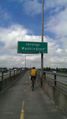
On the I-205 bridge over the Columbia
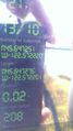
Numbers proving that we were well within the GPS margin of error of the coordinates

Goofy grins!


