Difference between revisions of "2013-09-19 31 34"
imported>LiNaK (Created page with "{{subst:Expedition |lat = 31 |lon = 34 |date = 2013-09-19 }}") |
imported>FippeBot m (Location) |
||
| (2 intermediate revisions by one other user not shown) | |||
| Line 18: | Line 18: | ||
__NOTOC__ | __NOTOC__ | ||
== Location == | == Location == | ||
| − | + | In a field at the Lachish region, close to Highway 6 and The Israel Trail, between Lachish and Ahuzam. | |
== Participants == | == Participants == | ||
| − | + | Omri ([[User:LiNaK|LinaK]]) | |
| − | + | ||
| + | Maoz | ||
== Plans == | == Plans == | ||
| − | + | Woke up on Sukkot morning and dad asked if I had plans for today. We decided to check the hash for today and found it was reachable, so got to the car and planned to drive to Lachish, and see if The Israel Trail is drive-able at this area. If not than maybe we could walk it, though it should be a pretty long and bland walk. | |
== Expedition == | == Expedition == | ||
| − | + | We drove south to the area, and manged to find a drive-able path connecting with the walking trail. Good thing we did as well, as we got there mid-day, and temperatures were around 40 degrees Celsius. After driving a while between the vines and fields (dessert agriculture!), the coordinates seemed close enough, so we veered to a tractor trail in an empty field and I tried to decide where should we stop the car based on the GPS signal. We found a tree where we could park the car in the shade, and than followed the coordinates until we were at the exact spot, that had absolutely nothing on it, so I added an XKCD marker there to make it a little less of a nothing. | |
| + | |||
| + | On the way back to the main road we also had a chance to taste grapes right from the vineyard (much sweeter than regular grapes), and climb up to Tel Lachish, a surprisingly impressive archaeological site of a settlement that existed there on and of from 4th millennium BC to the late Hellenistic area (1st century BC), that somehow manged to stay pretty unknown compared to other, less impressive sights. It has been a Canaanite settlement, was under Egyptian influence, destroyed by Sea Peoples or Israelites, rebuilt to become the second biggest city in the kingdom of Judah, hit by a big earthquake, was under sages by Assyria and Babylon, served as a regional capitol in the Persian Empire, finally declining as part of the Empire established by Alexander the Great. And we found some well preserved shards, but decided not to take them home. | ||
| + | |||
| + | Before returning home we also visited modern Lachish itself, though it was nothing special, and found a great restaurant at Kibbutz Gat. | ||
| − | |||
| − | |||
== Photos == | == Photos == | ||
| Line 38: | Line 41: | ||
--> | --> | ||
<gallery perrow="5"> | <gallery perrow="5"> | ||
| + | Image:2013-09-19_31_34_field.jpg | The empty field. | ||
| + | Image:2013-09-19_31_34_field2.jpg | Around the hash point. | ||
| + | Image:2013-09-19_31_34_mark.jpg | XKCD marker. | ||
| + | Image:2013-09-19_31_34_me.jpg | How come there's never a good photo of me from these trips? | ||
| + | Image:2013-09-19_31_34_dad.jpg | Dad's photo's fine though. | ||
| + | Image:2013-09-19_31_34_trees.jpg | Along the walk. | ||
| + | Image:2013-09-19_31_34_view.jpg | The brownest season there is... | ||
| + | Image:2013-09-19_31_34_trail.jpg | The Israel Trail passes everywhere! | ||
| + | Image:2013-09-19_31_34_grape.jpg | Grapes. | ||
| + | Image:2013-09-19_31_34_vine.jpg | Dessert Vineyards. | ||
| + | Image:2013-09-19_31_34_house.jpg | An ancient house. | ||
| + | Image:2013-09-19_31_34_shred.jpg | The place was filled with these. | ||
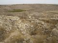
| + | Image:2013-09-19_31_34_rocks.jpg | Archaeology! | ||
| + | Image:2013-09-19_31_34_green.jpg | The view wasn't all brown though. | ||
| + | Image:2013-09-19_31_34_well.jpg | Ancient well (deeper than picture suggests). | ||
| + | Image:2013-09-19_31_34_wall.jpg | Ruined city walls. | ||
| + | Image:2013-09-19_31_34_view2.jpg | View from the Tel. | ||
| + | Image:2013-09-19_31_34_pot.jpg | Some discoveries of our own. | ||
| + | Image:2013-09-19_31_34_pot2.jpg | And another one. | ||
</gallery> | </gallery> | ||
| − | |||
| − | |||
| − | |||
| + | [[Category:Expeditions]] | ||
| − | |||
| − | |||
| − | |||
| − | |||
| − | |||
| − | |||
| − | |||
| − | |||
| − | |||
| − | |||
| − | |||
| − | |||
[[Category:Expeditions with photos]] | [[Category:Expeditions with photos]] | ||
| − | + | ||
| − | |||
| − | |||
| − | |||
| − | |||
[[Category:Coordinates reached]] | [[Category:Coordinates reached]] | ||
| − | + | {{location|IL|D|AS}} | |
| − | |||
| − | |||
| − | |||
| − | |||
| − | |||
| − | |||
| − | |||
| − | |||
| − | |||
| − | |||
| − | |||
| − | |||
| − | |||
| − | |||
| − | |||
| − | |||
| − | |||
Latest revision as of 12:31, 14 July 2019
| Thu 19 Sep 2013 in 31,34: 31.5359765, 34.8002534 geohashing.info google osm bing/os kml crox |
Location
In a field at the Lachish region, close to Highway 6 and The Israel Trail, between Lachish and Ahuzam.
Participants
Omri (LinaK)
Maoz
Plans
Woke up on Sukkot morning and dad asked if I had plans for today. We decided to check the hash for today and found it was reachable, so got to the car and planned to drive to Lachish, and see if The Israel Trail is drive-able at this area. If not than maybe we could walk it, though it should be a pretty long and bland walk.
Expedition
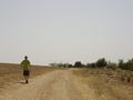
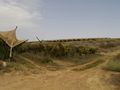
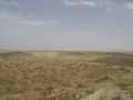
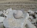
We drove south to the area, and manged to find a drive-able path connecting with the walking trail. Good thing we did as well, as we got there mid-day, and temperatures were around 40 degrees Celsius. After driving a while between the vines and fields (dessert agriculture!), the coordinates seemed close enough, so we veered to a tractor trail in an empty field and I tried to decide where should we stop the car based on the GPS signal. We found a tree where we could park the car in the shade, and than followed the coordinates until we were at the exact spot, that had absolutely nothing on it, so I added an XKCD marker there to make it a little less of a nothing.
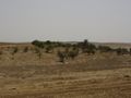
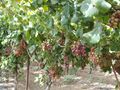
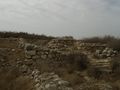
On the way back to the main road we also had a chance to taste grapes right from the vineyard (much sweeter than regular grapes), and climb up to Tel Lachish, a surprisingly impressive archaeological site of a settlement that existed there on and of from 4th millennium BC to the late Hellenistic area (1st century BC), that somehow manged to stay pretty unknown compared to other, less impressive sights. It has been a Canaanite settlement, was under Egyptian influence, destroyed by Sea Peoples or Israelites, rebuilt to become the second biggest city in the kingdom of Judah, hit by a big earthquake, was under sages by Assyria and Babylon, served as a regional capitol in the Persian Empire, finally declining as part of the Empire established by Alexander the Great. And we found some well preserved shards, but decided not to take them home.
Before returning home we also visited modern Lachish itself, though it was nothing special, and found a great restaurant at Kibbutz Gat.
Photos
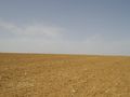
The empty field.
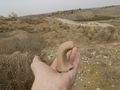
Around the hash point.
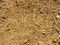
XKCD marker.
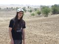
How come there's never a good photo of me from these trips?
Dad's photo's fine though.
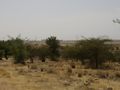
Along the walk.
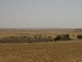
The brownest season there is...
The Israel Trail passes everywhere!
Grapes.
Dessert Vineyards.
An ancient house.
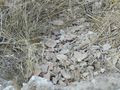
The place was filled with these.
Archaeology!
The view wasn't all brown though.
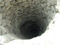
Ancient well (deeper than picture suggests).
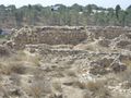
Ruined city walls.
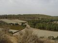
View from the Tel.
Some discoveries of our own.
And another one.


