Difference between revisions of "2013-09-24 51 9"
imported>GeorgDerReisende (new expedition to Brakel) |
imported>GeorgDerReisende (expedition report added) |
||
| Line 37: | Line 37: | ||
== Expedition == | == Expedition == | ||
| − | + | ||
| + | I have left home at 11:30, waited at the ''Wilhelmshöhe'' junction from 12:30 to 13:10, got a lift to the junction of Warburg, where I arrived at 13:26 and then waited for 30 minutes. I arrived near the hash at 14:27. From there I walked along the edge of two fields to the hash, where I arrived at 14:44. To create a sign I collected some stones from the field. Then I walked back to the road along and through the forest. My adventure ended at 16:45. My way home began at the junction to Bellersen at the B 252. I refused a lift with the first two cars to Brakel. Then I got a car to Rheder, from there a car to Peckelsheim, from there a car to the northern junction of Warburg and from there a truck to the truckstop ''Lohfeldener Rüssel''. Then I walked to the bus stop and I arrived at home at 19:55. | ||
== Tracklog == | == Tracklog == | ||
| Line 43: | Line 44: | ||
== Photos == | == Photos == | ||
| − | |||
| − | |||
| − | |||
<gallery perrow="5"> | <gallery perrow="5"> | ||
| + | Image:2013-09-24 51 9 GeorgDerReisende 0881.jpg | there it is! | ||
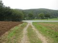
| + | Image:2013-09-24 51 9 GeorgDerReisende 0883.jpg | this is my way | ||
| + | Image:2013-09-24 51 9 GeorgDerReisende 0892.jpg | proof1 | ||
| + | Image:2013-09-24 51 9 GeorgDerReisende 0893.jpg | the hash | ||
| + | Image:2013-09-24 51 9 GeorgDerReisende 0895.jpg | proof2 | ||
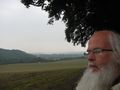
| + | Image:2013-09-24 51 9 GeorgDerReisende 0897.jpg | view to the north | ||
| + | Image:2013-09-24 51 9 GeorgDerReisende 0899.jpg | view to the east | ||
| + | Image:2013-09-24 51 9 GeorgDerReisende 0901.jpg | view to the southeast | ||
| + | Image:2013-09-24 51 9 GeorgDerReisende 0903.jpg | view to the south | ||
| + | Image:2013-09-24 51 9 GeorgDerReisende 0908.jpg | view into the forest | ||
| + | Image:2013-09-24 51 9 GeorgDerReisende 0911.jpg | the sign | ||
| + | Image:2013-09-24 51 9 GeorgDerReisende 0913.jpg | the internet was here! | ||
| + | Image:2013-09-24 51 9 GeorgDerReisende 0917.jpg | grin | ||
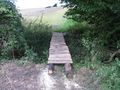
| + | Image:2013-09-24 51 9 GeorgDerReisende 0927.jpg | a bridge | ||
| + | Image:2013-09-24 51 9 GeorgDerReisende 0980.jpg | this is the end | ||
</gallery> | </gallery> | ||
| Line 53: | Line 66: | ||
<!-- Add any achievement ribbons you earned below, or remove this section --> | <!-- Add any achievement ribbons you earned below, or remove this section --> | ||
| + | {{Thumbs Up | latitude = 51 | longitude = 9 | date = 2013-09-24 | name = GeorgDerReisende }} | ||
| − | + | [[Category:Expeditions]] | |
| − | |||
| − | [[Category: | ||
| − | + | [[Category:Expeditions with photos]] | |
| − | |||
| − | [[Category: | ||
| − | |||
| − | |||
| − | |||
| − | |||
| − | |||
| − | |||
| − | |||
| − | |||
| − | |||
| − | |||
[[Category:Coordinates reached]] | [[Category:Coordinates reached]] | ||
| − | |||
| − | |||
| − | |||
| − | |||
| − | |||
| − | |||
| − | |||
| − | |||
| − | |||
| − | |||
| − | |||
| − | |||
| − | |||
| − | |||
| − | |||
| − | |||
| − | |||
| − | |||
Revision as of 19:10, 24 September 2013
| Tue 24 Sep 2013 in 51,9: 51.7441561, 9.1681770 geohashing.info google osm bing/os kml crox |
Location
lat.74415 lon.16817 — at an edge of a forest north of Brakel
Participants
Plans
The peeron map doesn't show a marker for tuesday. So I have calculated it by myself. As proof I have calculated the date which is shown at The Algorithm and those of the last weekend. I have used http://elmar-eigner.de/md5_maker.html for the calculating of the md5 and http://www.easysurf.cc/cnver17.htm#bf16tobf10 for the calculating of the decimal fractions. The result is:
| 2005-05-26-10458.68 | db9318c2259923d0 | 8b672cb305440f97 | lat.8577132677070023 | lon.5445430695592821 |
| 2013-09-21-15635.09 | 5fa26ea94f387b29 | b57bdcb21e5af73d | lat.3735722697594798 | lon.7089212355480007 |
| 2013-09-22-15635.09 | ba4d3c191547a4ba | 6111e4205c6ecf96 | lat.727741008876619 | lon.3791792468077191 |
| 2013-09-23-15635.09 | e5eac75c66f8bbbd | 8dda3de131d0ebab | lat.8981136894790066 | lon.5541113543311585 |
| 2013-09-24-15452.31 | be8103da25d3f6ab | 2b0da6610d3e909f | lat.7441561133944815 | lon.16817703122546335 |
Given the result to my Garmin leads me to the hash. North of Brakel. Hitchhiking as usual.
I hope I am right.
Expedition
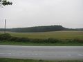
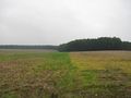
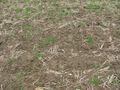
I have left home at 11:30, waited at the Wilhelmshöhe junction from 12:30 to 13:10, got a lift to the junction of Warburg, where I arrived at 13:26 and then waited for 30 minutes. I arrived near the hash at 14:27. From there I walked along the edge of two fields to the hash, where I arrived at 14:44. To create a sign I collected some stones from the field. Then I walked back to the road along and through the forest. My adventure ended at 16:45. My way home began at the junction to Bellersen at the B 252. I refused a lift with the first two cars to Brakel. Then I got a car to Rheder, from there a car to Peckelsheim, from there a car to the northern junction of Warburg and from there a truck to the truckstop Lohfeldener Rüssel. Then I walked to the bus stop and I arrived at home at 19:55.
Tracklog
Photos
there it is!
this is my way
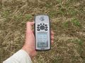
proof1
the hash
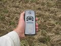
proof2
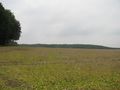
view to the north
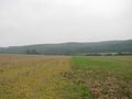
view to the east
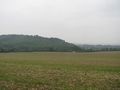
view to the southeast
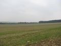
view to the south
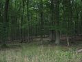
view into the forest
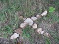
the sign
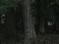
the internet was here!
grin
a bridge
this is the end


Achievements
GeorgDerReisende earned the Thumbs Up Geohash Achievement
|