Difference between revisions of "2013-10-25 49 8"
imported>Q-Owl (Created page with "<!-- If you did not specify these parameters in the template, please substitute appropriate values for IMAGE, LAT, LON, and DATE (YYYY-MM-DD format) [[Image:{{{image|IMAGE}}...") |
imported>FippeBot m (Location) |
||
| (7 intermediate revisions by one other user not shown) | |||
| Line 11: | Line 11: | ||
| lat=49 | | lat=49 | ||
| lon=8 | | lon=8 | ||
| − | | date=2013- | + | | date=2013-10-25 |
}} | }} | ||
| Line 18: | Line 18: | ||
[[graticule|Graticule]] [[Mannheim, Germany|Mannheim (49, 8)]]: | [[graticule|Graticule]] [[Mannheim, Germany|Mannheim (49, 8)]]: | ||
| − | + | The hashpoint is located on a field south of [[wikipedia:Gernsheim|Gernsheim]] and west of Klein Rohrheim near the little river [https://de.wikipedia.org/wiki/Lauter_%28Odenwald%29 Lauter/Winkelbach]. In the south of the field a little road leads from Klein Rohrheim to a home for animals. | |
== Participants == | == Participants == | ||
| Line 24: | Line 24: | ||
== Expedition == | == Expedition == | ||
| − | + | The weather was cloudy but dry and I needed recreation and recovery, so the hashpoint was a good reason to go outdoors. | |
| + | |||
| + | The field was easy to be found, but fresh sowed barley or rye grew there as little plants. Since I don't like to tramp onto my future beer or bread (or worse to perform the 'GPS dance' on it), I had to keep on traktor tracks crossing the field. And I also do not need to encounter a blustering German farmer.^^ One muggel who asked me, what I was seeking here was enough for this afternoon. | ||
| + | |||
| + | I tried three traktor tracks until I found out which would lead next to the hashpoint. So the GPS device at least displayed about 9.3 m to the point with an accuracy of 4 m. Good that I had rubber boots in the car and best to wear them here! | ||
| + | |||
| + | About 0.9 km from the hashpoint, but in direct sight (in the west, at the edge of the wood) was the [http://www.geocaching.com/geocache/GC36MH4_3-2-1-go GC36MH4] geocache which we could not log in april, because a hunter with gun sat next to it on a little raised hide. But now it was to be found without the hunter. | ||
| + | |||
| + | After this I had some time near the harbour of [[wikipedia:Gernsheim|Gernsheim]], watchng a container ship to be loaded, the ferry sailing across the river and the calm streaming of the Rhine River during sunset. | ||
| + | |||
| + | (I am not used to write English texts. So you may correct it if you find mistakes.) | ||
== Photos == | == Photos == | ||
| Line 31: | Line 41: | ||
http://wiki.xkcd.com/wgh/index.php?title=Special%3AListFiles&limit=50&ilsearch=&user=Q-Owl | http://wiki.xkcd.com/wgh/index.php?title=Special%3AListFiles&limit=50&ilsearch=&user=Q-Owl | ||
<gallery perrow="5" > | <gallery perrow="5" > | ||
| − | --> | + | --> <gallery> |
| + | Image:20131025 field-kl.jpg | Field with HP on it | ||
| + | Image:20131025 track-kl.jpg | With boots on track | ||
| + | Image:2013-10-25-screenshot-kl.jpg | Screenshot (Smartphone) | ||
| + | </gallery> | ||
| + | <gallery> | ||
| + | Image:20131025 north-kl.jpg | North | ||
| + | Image:20131025 west-kl.jpg | West | ||
| + | Image:20131025 south-kl.jpg | South | ||
| + | Image:20131025 east-kl.jpg | East - Klein Rohrheim | ||
| + | </gallery> | ||
| − | == Achievements == | + | == Achievements / Honorable Mention == |
| − | + | {{#vardefine:ribbonwidth|700px}} | |
| + | |||
| + | {{Land geohash | ||
| + | | latitude = 49 | ||
| + | | longitude = 8 | ||
| + | | date = 2013-10-25 | ||
| + | | name = [[User:Q-Owl|Q-Owl]] | ||
| + | }} | ||
| + | {{Hash collision | latitude = 49 | longitude = 8 | date = 2013-10-25 | name = Q-Owl | | ||
| + | id = GC36MH4 | link = http://coord.info/GC36MH4 | | ||
| + | distance = 0.9 km | honor = jes }} 0.9 km from the hashpoint, but in direct sight. | ||
<!-- =============== USEFUL CATEGORIES FOLLOW ================ | <!-- =============== USEFUL CATEGORIES FOLLOW ================ | ||
| Line 54: | Line 84: | ||
<!-- if you reached your coords: --> | <!-- if you reached your coords: --> | ||
[[Category:Coordinates reached]] | [[Category:Coordinates reached]] | ||
| + | {{location|DE|HE|GG}} | ||
Latest revision as of 04:26, 14 August 2019
| Fri 25 Oct 2013 in 49,8: 49.7349580, 8.4820262 geohashing.info google osm bing/os kml crox |
Location
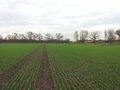
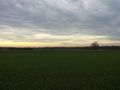
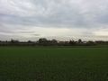
The hashpoint is located on a field south of Gernsheim and west of Klein Rohrheim near the little river Lauter/Winkelbach. In the south of the field a little road leads from Klein Rohrheim to a home for animals.
Participants
Expedition
The weather was cloudy but dry and I needed recreation and recovery, so the hashpoint was a good reason to go outdoors.
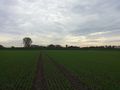
The field was easy to be found, but fresh sowed barley or rye grew there as little plants. Since I don't like to tramp onto my future beer or bread (or worse to perform the 'GPS dance' on it), I had to keep on traktor tracks crossing the field. And I also do not need to encounter a blustering German farmer.^^ One muggel who asked me, what I was seeking here was enough for this afternoon.
I tried three traktor tracks until I found out which would lead next to the hashpoint. So the GPS device at least displayed about 9.3 m to the point with an accuracy of 4 m. Good that I had rubber boots in the car and best to wear them here!
About 0.9 km from the hashpoint, but in direct sight (in the west, at the edge of the wood) was the GC36MH4 geocache which we could not log in april, because a hunter with gun sat next to it on a little raised hide. But now it was to be found without the hunter.
After this I had some time near the harbour of Gernsheim, watchng a container ship to be loaded, the ferry sailing across the river and the calm streaming of the Rhine River during sunset.
(I am not used to write English texts. So you may correct it if you find mistakes.)
Photos
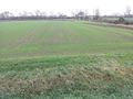
Field with HP on it
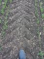
With boots on track
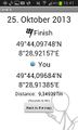
Screenshot (Smartphone)


North
West
South
East - Klein Rohrheim


Achievements / Honorable Mention
Q-Owl earned the Land geohash achievement
|
Q-Owl earned the Hash collision honorable mention
|
0.9 km from the hashpoint, but in direct sight.