Difference between revisions of "2013-12-25 33 -117"
From Geohashing
imported>Jiml m (Help APBot out with parsing) |
imported>FippeBot m (Location) |
||
| Line 24: | Line 24: | ||
[[Category:Expeditions with photos]] | [[Category:Expeditions with photos]] | ||
[[Category:Coordinates reached]] | [[Category:Coordinates reached]] | ||
| + | {{location|US|CA|SD}} | ||
Latest revision as of 04:59, 14 August 2019
| Wed 25 Dec 2013 in 33,-117: 33.0694823, -117.0841345 geohashing.info google osm bing/os kml crox |
Location
On the northeast side of Bernardo Mountain, just downhill from the Bernardo Summit Trail
Participants
- LucasBrown and
- his sister
Photos
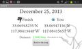
Geohash Droid details page at the hashpoint
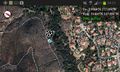
Map at hashpoint
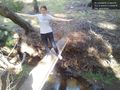
A plank bridge over a creek near the hashpoint @33.0689,-117.0830


Achievements
- Land geohash