Difference between revisions of "2014-02-03 47 -122"
From Geohashing
imported>Thomcat (Seattle expedition on the way to work) |
imported>Thomcat ([live picture] Good morning! [http://www.openstreetmap.org/?lat=47.67949407&lon=-122.24833020&zoom=16&layers=B000FTF @47.6795,-122.2483]) |
||
| Line 25: | Line 25: | ||
--> | --> | ||
<gallery perrow="5"> | <gallery perrow="5"> | ||
| + | |||
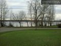
| + | Image:2014-02-03_47_-122_08-19-33-615.jpg | Good morning! [http://www.openstreetmap.org/?lat=47.67949407&lon=-122.24833020&zoom=16&layers=B000FTF @47.6795,-122.2483] | ||
</gallery> | </gallery> | ||
Revision as of 16:19, 3 February 2014
| Mon 3 Feb 2014 in Seattle: 47.6794904, -122.2483381 geohashing.info google osm bing/os kml crox |
Location
Magnuson Park, south of the Kite Hill and north of the Boat Launch. Fairly close to the Swimming Beach.
Participants
Plans
Stop by on the way to work for Seattle's 180th expedition and likely 126th success.
Expedition
I commute to work between Ballard and Bothell, and usually take Lake City Way then state highway 522. Magnuson park is not strictly on-the-way, but it's not far off - and this evening I will have other commitments.
Photos
Good morning! @47.6795,-122.2483
