Difference between revisions of "2014-02-05 56 -2"
From Geohashing
imported>Wasindear (Created page with "{{meetup graticule | lat=56 | lon=-2 | date=2014-02-05 }}") |
imported>FippeBot m (Location) |
||
| (14 intermediate revisions by 3 users not shown) | |||
| Line 1: | Line 1: | ||
| + | |||
| + | <!-- If you did not specify these parameters in the template, please substitute appropriate values for IMAGE, LAT, LON, and DATE (YYYY-MM-DD format) | ||
| + | |||
| + | [[Image:{{{image|IMAGE}}}|thumb|left]] | ||
| + | |||
| + | Remove this section if you don't want an image at the top (left) of your report. You should remove the "Image:" or "File:" | ||
| + | tag from your image file name, and replace the all upper-case word IMAGE in the above line. | ||
| + | |||
| + | And DON'T FORGET to add your expedition and the best photo you took to the gallery on the Main Page! We'd love to read your report, but that means we first have to discover it! :) | ||
| + | --> | ||
{{meetup graticule | {{meetup graticule | ||
| lat=56 | | lat=56 | ||
| Line 4: | Line 14: | ||
| date=2014-02-05 | | date=2014-02-05 | ||
}} | }} | ||
| + | |||
| + | |||
| + | __NOTOC__ | ||
| + | == Location == | ||
| + | |||
| + | The hashpoint was on the border between a garden and a field. | ||
| + | |||
| + | == Participants == | ||
| + | |||
| + | *[[User:Wasindear|Wasindear]] | ||
| + | *[[User:Squibakou|Squibakou]] | ||
| + | |||
| + | == Plans == | ||
| + | |||
| + | [[User:Squibakou|Squibakou]] and [[User:Wasindear|Wasindear]] planned to go to the hashpoint after our classes, cycling from the area known as the North Haugh out to the hashpoint. | ||
| + | |||
| + | == Expedition == | ||
| + | |||
| + | As planned we set out at about 4:30pm under less than desirable conditions. It took about 15 minutes to reach the location at which time the rain abated for long enough to get some pictures. We then cycled back into town, with only a minor set back when we both hit a pothole and [[User:Squibakou|Squibakou]] bike chain came off. | ||
| + | |||
| + | == Photos == | ||
| + | |||
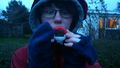
| + | <gallery perrow="5"> | ||
| + | Image:2014-02-05_56_-2_01.jpg|Squibakou almost falls | ||
| + | Image:2014-02-05_56_-2_02.jpg|Squibakou hiding from rain | ||
| + | Image:2014-02-05_56_-2_03.jpg|Wasindear looking a bit crazy | ||
| + | Image:2014-02-05_56_-2_04.jpg|The field looking field-ish | ||
| + | Image:2014-02-05_56_-2_05.jpg|PEACE! | ||
| + | Image:2014-02-05_56_-2_06.jpg|Togepi seems to have enjoyed the trip | ||
| + | Image:2014-02-05_56_-2_07.png|Confirmation screenshot | ||
| + | </gallery> | ||
| + | |||
| + | == Achievements == | ||
| + | {{#vardefine:ribbonwidth|800px}} | ||
| + | |||
| + | * Land geohash | ||
| + | * Bike Geohash | ||
| + | |||
| + | |||
| + | [[Category:Expeditions]] | ||
| + | |||
| + | [[Category:Expeditions with photos]] | ||
| + | [[Category:Coordinates reached]] | ||
| + | {{location|GB|SCT|FIF}} | ||
Latest revision as of 05:25, 14 August 2019
| Wed 5 Feb 2014 in 56,-2: 56.3355068, -2.8279398 geohashing.info google osm bing/os kml crox |
Location
The hashpoint was on the border between a garden and a field.
Participants
Plans
Squibakou and Wasindear planned to go to the hashpoint after our classes, cycling from the area known as the North Haugh out to the hashpoint.
Expedition
As planned we set out at about 4:30pm under less than desirable conditions. It took about 15 minutes to reach the location at which time the rain abated for long enough to get some pictures. We then cycled back into town, with only a minor set back when we both hit a pothole and Squibakou bike chain came off.
Photos
Squibakou almost falls
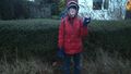
Squibakou hiding from rain

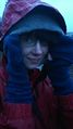
Wasindear looking a bit crazy
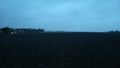
The field looking field-ish
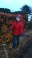
PEACE!
Togepi seems to have enjoyed the trip
Confirmation screenshot


Achievements
- Land geohash
- Bike Geohash