Difference between revisions of "2014-02-15 51 11"
imported>ScepticAnna |
imported>ScepticAnna |
||
| Line 21: | Line 21: | ||
== Participants == | == Participants == | ||
| − | + | * [[User:ScepticAnna|ScepticAnna]] | |
| − | |||
== Plans == | == Plans == | ||
| Line 28: | Line 27: | ||
== Expedition == | == Expedition == | ||
| − | + | This expedition might as well be titled "A tour through the industrial zones and Fasching Clubs of Erfurt". | |
| + | |||
| + | Starting from Erfurt main station, going to the north meant going through several industrial zones. Then I passed under Autobahn A71 and went on to Stotternheim, where I had to detour around some Fasching Club activity which was blocking the bike lane. On a country road between plowed fields I went on to Schwansee, where I encountered yet another Fasching Club activity. | ||
| + | |||
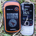
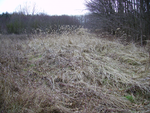
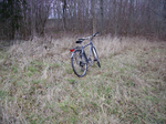
| + | The hashpoint was only a few hundred meters away from Schwansee, between a fenced-in meadow and a wooded area on a grassy track. GPS switched wildly between 0 meters and 4 meters distance to the point; and since it also reported an accuracy of 5 meters I called it good enough. | ||
| + | |||
| − | |||
| − | |||
== Photos == | == Photos == | ||
| − | |||
| − | |||
| − | |||
<gallery perrow="5"> | <gallery perrow="5"> | ||
</gallery> | </gallery> | ||
| + | {{#vardefine:gaWidth|150}} | ||
| + | {{#vardefine:gaHeight|127}} | ||
| + | {{#vardefine:gaLines|2}} | ||
| + | {{Gallery2| | ||
| + | {{GalleryItem | Image:2014-02-15_51_11-proof.png|Proof of location.}} | ||
| + | {{GalleryItem | Image:2014-02-15_51_11-grasses.png|The hashpoint was on a grass-covered track...}} | ||
| + | {{GalleryItem | Image:2014-02-15_51_11-bike.png|...next to a wooded area.}} | ||
| + | |||
| + | }} | ||
== Achievements == | == Achievements == | ||
{{#vardefine:ribbonwidth|800px}} | {{#vardefine:ribbonwidth|800px}} | ||
| + | {{Reverse Regional | ||
| + | |||
| + | | latitude = 51 | ||
| + | | longitude = 11 | ||
| + | | name = [[User:ScepticAnna|ScepticAnna]] ([[User talk:ScepticAnna|talk]]) | ||
| + | | count = 2 | ||
| + | | graticule = Halle (Saale), Germany | ||
| + | | level = state | ||
| + | |||
| + | |||
| + | }} | ||
<!-- Add any achievement ribbons you earned below, or remove this section --> | <!-- Add any achievement ribbons you earned below, or remove this section --> | ||
| Line 52: | Line 71: | ||
| − | |||
[[Category:Expeditions]] | [[Category:Expeditions]] | ||
| − | |||
[[Category:Expeditions with photos]] | [[Category:Expeditions with photos]] | ||
| − | + | ||
| − | + | ||
| − | |||
| − | + | ||
[[Category:Coordinates reached]] | [[Category:Coordinates reached]] | ||
| − | |||
| − | |||
| − | |||
| − | |||
| − | |||
| − | |||
| − | |||
| − | |||
| − | |||
| − | |||
| − | |||
| − | |||
| − | |||
| − | |||
| − | |||
| − | |||
| − | |||
| − | |||
Revision as of 07:35, 16 February 2014
| Sat 15 Feb 2014 in 51,11: 51.0803886, 11.0935817 geohashing.info google osm bing/os kml crox |
Location
In a park or small wooded area near Schwansee, north of Erfurt.
Participants
Plans
ScepticAnna (talk): Take the train to Erfurt, ride my bike to the hashpoint. I will be there at 14:00, 15:00 at the latest, because I have stuff in the early evening.
Expedition
This expedition might as well be titled "A tour through the industrial zones and Fasching Clubs of Erfurt".
Starting from Erfurt main station, going to the north meant going through several industrial zones. Then I passed under Autobahn A71 and went on to Stotternheim, where I had to detour around some Fasching Club activity which was blocking the bike lane. On a country road between plowed fields I went on to Schwansee, where I encountered yet another Fasching Club activity.
The hashpoint was only a few hundred meters away from Schwansee, between a fenced-in meadow and a wooded area on a grassy track. GPS switched wildly between 0 meters and 4 meters distance to the point; and since it also reported an accuracy of 5 meters I called it good enough.
Photos
|
Achievements
ScepticAnna (talk) earned the Reverse regional achievement
|


