Difference between revisions of "2014-02-24 34 -118"
From Geohashing
imported>Bravissimo594 m ([live picture] Marker nearby. [http://www.openstreetmap.org/?lat=34.25550000&lon=-118.30700000&zoom=16&layers=B000FTF @34.2555,-118.3070]) |
imported>Jiml m (Adjust result codes) |
||
| Line 17: | Line 17: | ||
}} | }} | ||
| − | + | ||
__NOTOC__ | __NOTOC__ | ||
== Location == | == Location == | ||
| − | + | ||
On Woodward Avenue in Sunland/Tujunga. [[Los Angeles, California|Los Angeles]] graticule. | On Woodward Avenue in Sunland/Tujunga. [[Los Angeles, California|Los Angeles]] graticule. | ||
== Participants == | == Participants == | ||
| − | + | ||
| − | + | * [[User:Bravissimo594|Bravissimo594]] | |
| − | * [[User:Bravissimo594|Bravissimo594]] | ||
* [[User:Boppy5|Boppy5]] | * [[User:Boppy5|Boppy5]] | ||
| Line 42: | Line 41: | ||
*Success at 8:30pm! -- [[User:Bravissimo594|Bravissimo594]] ([[User talk:Bravissimo594|talk]]) [http://www.openstreetmap.org/?lat=34.25542348&lon=-118.30710523&zoom=16&layers=B000FTF @34.2554,-118.3071] 23:34, 24 February 2014 (EST) | *Success at 8:30pm! -- [[User:Bravissimo594|Bravissimo594]] ([[User talk:Bravissimo594|talk]]) [http://www.openstreetmap.org/?lat=34.25542348&lon=-118.30710523&zoom=16&layers=B000FTF @34.2554,-118.3071] 23:34, 24 February 2014 (EST) | ||
| + | |||
| + | |||
== Tracklog == | == Tracklog == | ||
<!-- if your GPS device keeps a log, you may post a link here --> | <!-- if your GPS device keeps a log, you may post a link here --> | ||
== Photos == | == Photos == | ||
| − | + | ||
| − | |||
| − | |||
<gallery perrow="5"> | <gallery perrow="5"> | ||
Image:2014-02-24_34_-118_20-35-06-055.jpg | Late night success. [http://www.openstreetmap.org/?lat=34.25540000&lon=-118.30700000&zoom=16&layers=B000FTF @34.2554,-118.3070] | Image:2014-02-24_34_-118_20-35-06-055.jpg | Late night success. [http://www.openstreetmap.org/?lat=34.25540000&lon=-118.30700000&zoom=16&layers=B000FTF @34.2554,-118.3070] | ||
| − | |||
Image:2014-02-24_34_-118_20-37-19-245.jpg | Geohash Droid. [http://www.openstreetmap.org/?lat=34.25542398&lon=-118.30710093&zoom=16&layers=B000FTF @34.2554,-118.3071] | Image:2014-02-24_34_-118_20-37-19-245.jpg | Geohash Droid. [http://www.openstreetmap.org/?lat=34.25542398&lon=-118.30710093&zoom=16&layers=B000FTF @34.2554,-118.3071] | ||
| − | |||
Image:2014-02-24_34_-118_20-37-53-237.jpg | Street chalk. [http://www.openstreetmap.org/?lat=34.25540000&lon=-118.30700000&zoom=16&layers=B000FTF @34.2554,-118.3070] | Image:2014-02-24_34_-118_20-37-53-237.jpg | Street chalk. [http://www.openstreetmap.org/?lat=34.25540000&lon=-118.30700000&zoom=16&layers=B000FTF @34.2554,-118.3070] | ||
| + | Image:2014-02-24_34_-118_20-38-27-821.jpg | Marker nearby. [http://www.openstreetmap.org/?lat=34.25550000&lon=-118.30700000&zoom=16&layers=B000FTF @34.2555,-118.3070] | ||
| − | |||
</gallery> | </gallery> | ||
| Line 64: | Line 61: | ||
<!-- Add any achievement ribbons you earned below, or remove this section --> | <!-- Add any achievement ribbons you earned below, or remove this section --> | ||
| + | * Land geohash | ||
| − | |||
| − | |||
| − | |||
| − | + | [[Category:Expeditions]] | |
| − | + | [[Category:Expeditions with photos]] | |
| − | |||
| − | |||
| − | |||
| − | |||
| − | |||
| − | |||
| − | |||
| − | [[Category:Expeditions with photos]] | ||
| − | |||
| − | |||
| − | |||
| − | |||
| − | |||
[[Category:Coordinates reached]] | [[Category:Coordinates reached]] | ||
| − | |||
| − | |||
| − | |||
| − | |||
| − | |||
| − | |||
| − | |||
| − | |||
| − | |||
| − | |||
| − | |||
| − | |||
| − | |||
| − | |||
| − | |||
| − | |||
| − | |||
| − | |||
Revision as of 08:38, 25 February 2014
| Have you seen our geohashing marker? We'd love to hear from you! Click here to say "hi" and tell us what you've seen!
Curious about what geohashing is? Read more! |  |
| Mon 24 Feb 2014 in 34,-118: 34.2554328, -118.3070486 geohashing.info google osm bing/os kml crox |
Location
On Woodward Avenue in Sunland/Tujunga. Los Angeles graticule.
Participants
Plans
- If both Boppy5 and I can make it to the point at about 2:45pm then that is when we will be there. Otherwise, it will be 8:00pm this evening. Bravissimo594 (talk) 14:30, 24 February 2014 (EST)
- Too tricky to coordinate with lunchtime, so we will try to make it to the site at 8:00pm this evening. Bravissimo594 (talk) 15:50, 24 February 2014 (EST)
Poster
PDF poster for this expedition. Thanks to User:Crox/Poster.
Expedition
- Success at 8:30pm! -- Bravissimo594 (talk) @34.2554,-118.3071 23:34, 24 February 2014 (EST)
Tracklog
Photos
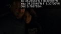
Late night success. @34.2554,-118.3070
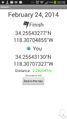
Geohash Droid. @34.2554,-118.3071
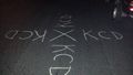
Street chalk. @34.2554,-118.3070
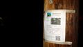
Marker nearby. @34.2555,-118.3070


Achievements
- Land geohash