Difference between revisions of "2014-05-20 52 13"
imported>Fenmar (Created page with "{{subst:Expedition |lat = 52 |lon = 13 |date = 2014-05-20 }}") |
imported>Fenmar (created report) |
||
| Line 18: | Line 18: | ||
__NOTOC__ | __NOTOC__ | ||
== Location == | == Location == | ||
| − | + | In a natural preserve circa 12km south of Potsdam | |
== Participants == | == Participants == | ||
| − | + | * [[User:Fenmar|Fenmar]] | |
| − | |||
== Plans == | == Plans == | ||
| − | + | It is supposed to be the first really warm day of the summer, so I guess I should go outside a bit... | |
== Expedition == | == Expedition == | ||
| − | + | The hash is circa 15km away from my home and the weather is really sunny today. I leave work early today to enjoy the rest of the day and make a trip to the Geohash. Plus, it is a good opportunity to try out my new phone mount for my bike. Google - lead the way! | |
| + | |||
| + | After cycling through the forests south of Potsdam, I enter the natural preserve Nuthe-Nieplitz. Besides the sign, I do not see a difference between the preserve and the other forests... The Hash is circa 500 meter into the forest and according to my map right beside a path. I leave my bike at a signpost and continue my journey. | ||
| + | |||
| + | The coordinates are easily reachable and after taking some pictures I leave before the mosquitoes can eat me alive. All in all a nice journey and perfect to conclude a slow workday. | ||
== Tracklog == | == Tracklog == | ||
| − | + | [https://drive.google.com/file/d/0B1DxM8SFvC8bbkg2S2pwUmxtMFE/edit?usp=sharing Tracklog Link] | |
== Photos == | == Photos == | ||
| Line 38: | Line 41: | ||
--> | --> | ||
<gallery perrow="5"> | <gallery perrow="5"> | ||
| + | Image:2014_05_20_52_13_NaturalPreserve.jpg | Fancy sign for a forest | ||
| + | Image:2014_05_20_52_13_SignPost.jpg | 500 meter to go | ||
| + | Image:2014_05_20_52_13_HashPoint.jpg | Coordinates Reached! | ||
| + | Image:2014_05_20_52_13_AtTheHash.jpg | Shameless Selfie | ||
| + | Image:2014_05_20_52_13_Panorama.jpg | Panorama taken at the HashPoint | ||
| + | Image:2014_05_20_52_13_Proof.png | Proof | ||
</gallery> | </gallery> | ||
| Line 43: | Line 52: | ||
{{#vardefine:ribbonwidth|800px}} | {{#vardefine:ribbonwidth|800px}} | ||
<!-- Add any achievement ribbons you earned below, or remove this section --> | <!-- Add any achievement ribbons you earned below, or remove this section --> | ||
| − | + | {{land geohash | latitude = 52 | longitude = 13 | date = 2014-05-20 | name = [[User:Fenmar|Fenmar]] }} | |
| + | {{Bicycle geohash | latitude = 52 | longitude = 13 | date = 2014-05-20 | name = [[User:Fenmar|Fenmar]] }} | ||
<!-- =============== USEFUL CATEGORIES FOLLOW ================ | <!-- =============== USEFUL CATEGORIES FOLLOW ================ | ||
Delete the next line ONLY if you have chosen the appropriate categories below. If you are unsure, don't worry. People will read your report and help you with the classification.--> | Delete the next line ONLY if you have chosen the appropriate categories below. If you are unsure, don't worry. People will read your report and help you with the classification.--> | ||
| − | |||
<!-- ==REQUEST FOR TWITTER BOT== Please leave either the New report or the Expedition planning category in as long as you work on it. This helps the twitter bot a lot with announcing the right outcome at the right moment. --> | <!-- ==REQUEST FOR TWITTER BOT== Please leave either the New report or the Expedition planning category in as long as you work on it. This helps the twitter bot a lot with announcing the right outcome at the right moment. --> | ||
| Line 56: | Line 65: | ||
--> | --> | ||
| + | [[Category:Expeditions]] | ||
| + | [[Category:Expeditions with photos]] | ||
<!-- An actual expedition: | <!-- An actual expedition: | ||
| − | |||
-- and one or more of -- | -- and one or more of -- | ||
| − | |||
[[Category:Expeditions with videos]] | [[Category:Expeditions with videos]] | ||
[[Category:Expedition without GPS]] | [[Category:Expedition without GPS]] | ||
--> | --> | ||
| + | [[Category:Coordinates reached]] | ||
<!-- if you reached your coords: | <!-- if you reached your coords: | ||
| − | |||
Revision as of 12:04, 21 May 2014
| Tue 20 May 2014 in 52,13: 52.2819076, 13.1064049 geohashing.info google osm bing/os kml crox |
Location
In a natural preserve circa 12km south of Potsdam
Participants
Plans
It is supposed to be the first really warm day of the summer, so I guess I should go outside a bit...
Expedition
The hash is circa 15km away from my home and the weather is really sunny today. I leave work early today to enjoy the rest of the day and make a trip to the Geohash. Plus, it is a good opportunity to try out my new phone mount for my bike. Google - lead the way!
After cycling through the forests south of Potsdam, I enter the natural preserve Nuthe-Nieplitz. Besides the sign, I do not see a difference between the preserve and the other forests... The Hash is circa 500 meter into the forest and according to my map right beside a path. I leave my bike at a signpost and continue my journey.
The coordinates are easily reachable and after taking some pictures I leave before the mosquitoes can eat me alive. All in all a nice journey and perfect to conclude a slow workday.
Tracklog
Photos
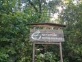
Fancy sign for a forest
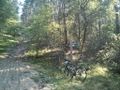
500 meter to go
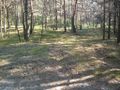
Coordinates Reached!
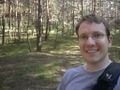
Shameless Selfie
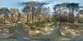
Panorama taken at the HashPoint
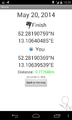
Proof


Achievements
Fenmar earned the Land geohash achievement
|
Fenmar earned the Bicycle geohash achievement
|