Difference between revisions of "2014-05-24 45 -122"
From Geohashing
imported>Michael5000 (Created page with "{{subst:Expedition |lat = 45 |lon = -122 |date = 2014-05-24 }}") |
imported>FippeBot m (Location) |
||
| (5 intermediate revisions by one other user not shown) | |||
| Line 18: | Line 18: | ||
__NOTOC__ | __NOTOC__ | ||
== Location == | == Location == | ||
| − | + | ||
| + | In woods just off of Canyon Creek Road, in Wilsonville. | ||
== Participants == | == Participants == | ||
| − | |||
| − | |||
| − | + | * [[User:Michael5000|Michael5000]] | |
| − | + | ||
== Expedition == | == Expedition == | ||
| − | |||
| − | + | I parked at Wilsonville High School and went on a nice run on the local roads, pausing at about the 2/3 point to scamper about 15 meters back into a wooded lot off the side of the road. I left my calling card on a branch in case anyone stopped by later. | |
| − | + | ||
| + | I don't like to carry a camera when I run, but I took a drive-by picture of the area as I started the drive home. | ||
== Photos == | == Photos == | ||
| − | + | ||
| − | |||
| − | |||
<gallery perrow="5"> | <gallery perrow="5"> | ||
| + | File:2014-05-24 45 -122 (1).JPG|The hashpoint is back there a bit. | ||
</gallery> | </gallery> | ||
| Line 45: | Line 43: | ||
| − | |||
| − | |||
| − | |||
| − | |||
| − | |||
| − | |||
| − | |||
| − | |||
| − | |||
| − | |||
| − | |||
| − | |||
[[Category:Expeditions]] | [[Category:Expeditions]] | ||
| − | |||
[[Category:Expeditions with photos]] | [[Category:Expeditions with photos]] | ||
| − | |||
| − | |||
| − | |||
| − | |||
| − | |||
[[Category:Coordinates reached]] | [[Category:Coordinates reached]] | ||
| − | + | <!-- or if you failed :( | |
[[Category:Coordinates not reached]] | [[Category:Coordinates not reached]] | ||
-- and a reason -- | -- and a reason -- | ||
| Line 84: | Line 64: | ||
(Don't forget to delete this final close comment marker) --> | (Don't forget to delete this final close comment marker) --> | ||
| + | {{location|US|OR|CC}} | ||
Latest revision as of 06:38, 14 August 2019
| Sat 24 May 2014 in 45,-122: 45.3266421, -122.7578641 geohashing.info google osm bing/os kml crox |
Location
In woods just off of Canyon Creek Road, in Wilsonville.
Participants
Expedition
I parked at Wilsonville High School and went on a nice run on the local roads, pausing at about the 2/3 point to scamper about 15 meters back into a wooded lot off the side of the road. I left my calling card on a branch in case anyone stopped by later.
I don't like to carry a camera when I run, but I took a drive-by picture of the area as I started the drive home.
Photos
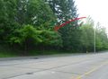
The hashpoint is back there a bit.
.JPG)