Difference between revisions of "2014-06-14 49 8"
imported>DODO (→Photos) |
imported>DODO (→Achievements) |
||
| Line 63: | Line 63: | ||
{{#vardefine:ribbonwidth|800px}} | {{#vardefine:ribbonwidth|800px}} | ||
<!-- Add any achievement ribbons you earned below, or remove this section --> | <!-- Add any achievement ribbons you earned below, or remove this section --> | ||
| + | == Achievements == | ||
| + | {{#vardefine:ribbonwidth|800px}} | ||
| + | {{land geohash | ||
| + | | latitude = 49 | ||
| + | | longitude = 8 | ||
| + | | date = 2014-06-14 | ||
| + | | name = DODO | ||
| + | }} | ||
| − | + | {{xkcd centurion|count=4}} | |
| − | |||
| − | |||
| − | |||
| − | + | {{bicycle geohash | |
| − | + | | latitude = 49 | |
| − | + | | longitude = 8 | |
| − | + | | date = 2014-06-14 | |
| + | | name = DODO | ||
| + | | distance = 70 KM | ||
| + | }} | ||
| − | |||
[[Category:Expeditions]] | [[Category:Expeditions]] | ||
| − | |||
[[Category:Expeditions with photos]] | [[Category:Expeditions with photos]] | ||
| − | |||
| − | |||
| − | |||
| − | |||
| − | |||
[[Category:Coordinates reached]] | [[Category:Coordinates reached]] | ||
| − | |||
| − | |||
| − | |||
| − | |||
| − | |||
| − | |||
| − | |||
| − | |||
| − | |||
| − | |||
| − | |||
| − | |||
| − | |||
| − | |||
| − | |||
| − | |||
| − | |||
| − | |||
Revision as of 20:41, 14 June 2014
| Sat 14 Jun 2014 in 49,8: 49.1130550, 8.4350396 geohashing.info google osm bing/os kml crox |
Location
Next to the Wiederaufbereitungsanlage Karlsruhe in the forest.
Participants
Plans
I want to go there by bike. I think, I can start at 2 so I hope to arrive 2 hours later at best meeting-time. Any Karlsruher hasher for a meetup?
Expedition
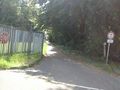
There was Kult(o)urnacht in Speyer yesterday and as I had to go to the market and to clean the stairs today, I couldn't start before 2 o'clock. I already knew the way to Graben-Neudorf from 2014-03-29, and so there was no big surprise on my way to the hash (except a stork maybe).
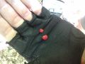
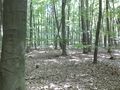
The hash was next to the former Wiederaufbereitungsanlage (nuclear reprocessing plant) Karlsruhe in the forest, just 100 m away from a path. On the place where I left my bike I found some (well, two) wild strawberries. I had to do a lot of hashdancing as the precission was pretty low in the forrest, but I did it down to a zero (although I din't get it on the photo). I had some fruits and some water at the hashpoint, but that doesn't qualify for a picnic, does it?
I've planned to try a tron achievement by going on to the ferry at Leimersheim and ride back to Speyer on the left side of the river rhine, but it was already a quarter past 4 when I left the hash and I wanted to be at home at 6 pm, because I bought some roast pork that needs two and a half hours in the oven. So I returned to Graben-Neudorf, but when I arrived at the station, the train had just gone. So I rided on to Germersheim and there I had more luck: a train started five minutes after I arrived at 17:49. So I reached home 5 minutes after six.
By the way, the roast pork was delicious :-)
Tracklog
Photos

Stork
two wild strawberries
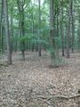
view to the hash
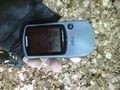
proof (second best I could get)
view from the hash (the lightning in the background is the former reprocessing plant)
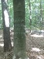
marker
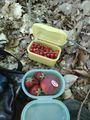
some more fresh fruits
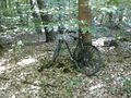
my bike in the forrest

reprocessing plant
reprocessing plant on the left side, hashpoint on the right side


Achievements
Achievements
DODO earned the Land geohash achievement
|
This user earned the xkcd Nullaturion achievement
|
DODO earned the Bicycle geohash achievement
|