Difference between revisions of "2014-06-15 45 -122"
imported>Michael5000 m (→Achievements) |
imported>FippeBot m (Location) |
||
| (6 intermediate revisions by 2 users not shown) | |||
| Line 15: | Line 15: | ||
}} | }} | ||
| − | |||
__NOTOC__ | __NOTOC__ | ||
== Location == | == Location == | ||
| Line 25: | Line 24: | ||
*[[User:Michael5000|Michael5000]] | *[[User:Michael5000|Michael5000]] | ||
*[[User:Frogman|Frogman]] | *[[User:Frogman|Frogman]] | ||
| − | |||
| − | |||
| − | |||
== Expedition == | == Expedition == | ||
| − | |||
| − | + | [[User:Michael5000|Michael5000]] and [[User:Frogman|Frogman]] drove north from Portland through alternating downpour and drizzle, but things cleared up around Scappoose and superfluous ice cream products were purchased from a drive-through restaurant. Continuing to St. Helens, we did a drive-by of the site on Germantown Road, resolving the only significant challenge of the expedition: parking. After that, it was a pleasant if slightly damp stroll up a hillside. The hashpoint was perhaps 100 meters in, just where meadow met the edge of the forest. We took pictures and generally felt victorious. | |
| − | |||
== Photos == | == Photos == | ||
| − | + | ||
| − | |||
| − | |||
<gallery perrow="5"> | <gallery perrow="5"> | ||
| + | File:2014-06-16 45 -122 us.JPG|I remembered to grin, but not to keep my eyes open. | ||
| + | File:2014-06-16 45 -122 gadget.JPG|This is the place. | ||
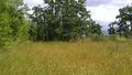
| + | File:2014-06-16 45 -122 growl.JPG|Enjoying the lightly wooded landscape. | ||
| + | File:2014-06-16 45 -122 view.JPG|Looking down the hill at the nursing home. | ||
| + | File:2014-06-16 45 -122 view2.JPG|Some trees to the east. | ||
| + | File:2014-06-15 45 -122 view3.JPG|Ominous clouds! | ||
| + | File:2014-06-15 45 -122 tiger.JPG|Some local wildlife. | ||
</gallery> | </gallery> | ||
| Line 46: | Line 45: | ||
<!-- Add any achievement ribbons you earned below, or remove this section --> | <!-- Add any achievement ribbons you earned below, or remove this section --> | ||
| − | [[File:2014-06-15 new area.jpg | + | [[File:2014-06-15 new area.jpg|left|thumb|This expedition takes care of the southeastern quarter of Columbia County on Michael5000's "stained glass" county-and-graticule map.]] |
| − | This expedition takes care of the southeastern quarter of Columbia County on Michael5000's "stained glass" county-and-graticule map. | ||
| − | |||
| − | |||
| − | |||
| − | |||
| − | |||
| − | |||
| − | |||
| − | |||
| − | |||
| − | |||
[[Category:Expeditions]] | [[Category:Expeditions]] | ||
[[Category:Expeditions with photos]] | [[Category:Expeditions with photos]] | ||
[[Category:Coordinates reached]] | [[Category:Coordinates reached]] | ||
| + | {{location|US|OR|CL}} | ||
Latest revision as of 06:53, 14 August 2019
| Sun 15 Jun 2014 in 45,-122: 45.8659918, -122.8243489 geohashing.info google osm bing/os kml crox |
Location
On a hillside just to the north of St. Helens, Oregon.
Participants
Expedition
Michael5000 and Frogman drove north from Portland through alternating downpour and drizzle, but things cleared up around Scappoose and superfluous ice cream products were purchased from a drive-through restaurant. Continuing to St. Helens, we did a drive-by of the site on Germantown Road, resolving the only significant challenge of the expedition: parking. After that, it was a pleasant if slightly damp stroll up a hillside. The hashpoint was perhaps 100 meters in, just where meadow met the edge of the forest. We took pictures and generally felt victorious.
Photos
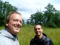
I remembered to grin, but not to keep my eyes open.
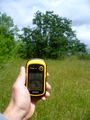
This is the place.
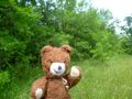
Enjoying the lightly wooded landscape.
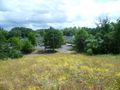
Looking down the hill at the nursing home.
Some trees to the east.
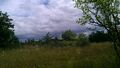
Ominous clouds!
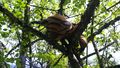
Some local wildlife.


