Difference between revisions of "2014-06-22 48 10"
imported>TheOneRing (Created page with "{{meetup graticule | lat=48 | lon=10 | date=2014-06-22 }} == Location == The geohash is next to the railway lines in Kissing, between Munich an Augsburg. == Who Went == Us...") |
imported>TheOneRing |
||
| Line 11: | Line 11: | ||
[[User:TheOneRing|TheOneRing]] - by public transport. | [[User:TheOneRing|TheOneRing]] - by public transport. | ||
| − | == The | + | == The Expedition == |
| − | I | + | I took a train at 11am to Augsburg, and left it in Kissing. I'm not kidding, the name of the village is written correctly. |
| + | |||
| + | Inside the train I switched on my eTrex to get the closest approach at highest legal velocity. I didn't want to miss the point, so I made a movie. Unfortunately, the resolution and focus was not very good, so I don't have a feasible proof. Therefore I don't claim the [[Speed racer achievement]]. | ||
| + | |||
| + | From the train station it was about 1km to the geohash. Every now and then, trains passed by, slow trains, express trains and freight trains. One has to mention, that these tracks are the main connection between Munich and Augsburg, and further to Stuttgart. | ||
| + | |||
| + | The geohash itself was on the edge of a field next to a dirt road. There, I took some photographs, amongst others a panaramic view of 360°. As long it is summer and warm, I was playing with the idea of getting the [[Geoflashing]] achievement. The opportunity was great, I only had to let pass by a bicyclist and another train, and finally I got undressed. | ||
| + | |||
| + | I had some time to get the next train, so I walked a little bit through Kissing, trying to find an ice cream parlour. But in this case I was unsuccessful, so I went back and waited at the platform. | ||
| + | |||
| + | == Photos == | ||
| + | <!-- Wrong file names, but location is right --> | ||
| + | <gallery perrow="5"> | ||
| + | Image:20140622_47_11Kissing.jpg|Welcome to Kissing and fell free to kiss your loved ones | ||
| + | Image:20140622_47_11GPS.jpg|Coordinates reached | ||
| + | Image:20140622_47_11Info.jpg|Some more information | ||
| + | Image:20140622_47_11Me.jpg|No clothes | ||
| + | Image:20140622_47_11Surrounding1.jpg|Panoramic view over the hash (the rucksack marks the geohash) | ||
| + | Image:20140622_47_11Surrounding2.jpg|Electricity lines | ||
| + | </gallery> | ||
== Achievements == | == Achievements == | ||
| − | + | {{land geohash | latitude = 48 | longitude = 10 | date = 2014-06-22 | name = TheOneRing}} | |
| + | {{Public transport geohash | latitude = 48 | longitude = 10 | date = 2014-06-22 | name = TheOneRing}} | ||
| + | {{Geoflashing | latitude = 48 | longitude = 10 | date = 2014-06-22 | name = TheOneRing }} | ||
| + | As the name of the village is so nice, I launch a Tale of Two Hashes challenge. | ||
| + | {{A Tale of Two Hashes challenge | latitude = 48 | longitude = 11 | date = 2014-06-22 | name = [[User:TheOneRing|TheOneRing]] | place = [http://en.wikipedia.org/wiki/Kissing,_Bavaria Kissing] | image = 20140622_47_11Kissing.jpg }} | ||
| + | |||
| + | [[Category:Expeditions]] | ||
| + | [[Category:Expeditions with photos]] | ||
| + | [[Category:Coordinates reached]] | ||
Revision as of 13:17, 22 June 2014
| Sun 22 Jun 2014 in 48,10: 48.2920665, 10.9609655 geohashing.info google osm bing/os kml crox |
Location
The geohash is next to the railway lines in Kissing, between Munich an Augsburg.
Who Went
TheOneRing - by public transport.
The Expedition
I took a train at 11am to Augsburg, and left it in Kissing. I'm not kidding, the name of the village is written correctly.
Inside the train I switched on my eTrex to get the closest approach at highest legal velocity. I didn't want to miss the point, so I made a movie. Unfortunately, the resolution and focus was not very good, so I don't have a feasible proof. Therefore I don't claim the Speed racer achievement.
From the train station it was about 1km to the geohash. Every now and then, trains passed by, slow trains, express trains and freight trains. One has to mention, that these tracks are the main connection between Munich and Augsburg, and further to Stuttgart.
The geohash itself was on the edge of a field next to a dirt road. There, I took some photographs, amongst others a panaramic view of 360°. As long it is summer and warm, I was playing with the idea of getting the Geoflashing achievement. The opportunity was great, I only had to let pass by a bicyclist and another train, and finally I got undressed.
I had some time to get the next train, so I walked a little bit through Kissing, trying to find an ice cream parlour. But in this case I was unsuccessful, so I went back and waited at the platform.
Photos
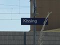
Welcome to Kissing and fell free to kiss your loved ones
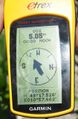
Coordinates reached
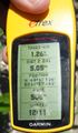
Some more information
- 20140622 47 11Me.jpg
No clothes
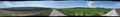
Panoramic view over the hash (the rucksack marks the geohash)
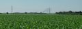
Electricity lines


Achievements
TheOneRing earned the Land geohash achievement
|
TheOneRing earned the Public transport geohash achievement
|
TheOneRing earned the Geoflashing Achievement
|
As the name of the village is so nice, I launch a Tale of Two Hashes challenge.
