Difference between revisions of "2014-07-12 51 -0"
imported>DanQ (Created page with "{{meetup graticule | lat=51 | lon=-0 | date=2014-07-12 }} <!-- edit as necessary --> __NOTOC__ == Location == <!-- where you've surveyed the hash to be --> On the edge of a ...") |
imported>FippeBot m (Location) |
||
| (3 intermediate revisions by 2 users not shown) | |||
| Line 1: | Line 1: | ||
| + | {{User:DanQ/Template:DanQBlog | url = https://danq.me/2014/07/12/geohashing-expedition-2014-07-12-51-0/ }} | ||
| + | |||
{{meetup graticule | {{meetup graticule | ||
| lat=51 | | lat=51 | ||
| Line 22: | Line 24: | ||
== Expedition == | == Expedition == | ||
<!-- how it all turned out. your narrative goes here. --> | <!-- how it all turned out. your narrative goes here. --> | ||
| − | ... | + | I was in Aylesbury this morning for an interview, and I'd discovered last night that a hashpoint had appeared pretty-much right between my home and the place I was visiting. It was off the major roads by a little way, but the day was beautiful and I relished the opportunity to go for an explore, by ZipCar and on foot. And that's exactly what I got. |
| + | |||
| + | After driving through the village of Ford, I came to the end of a road and the beginning of a private driveway, and found a place to park. The locals looked at me strangely as I found my bearings and set off up a bridleway. Suddenly, I realised that the hashpoint was off to my right somewhere, so I hacked my way through some trees to get closer to it. The hashpoint turned out to be pretty-much exactly on the spot of a tree, at the edge of a field. Sadly, the tree was on the otherside of a barbed wire fence, covered in vines, but I was (with some effort) able to lean far over to "touch" the hashpoint-tree, as shown in the photos. | ||
| + | |||
| + | Later, I got stuck in traffic and almost delivered the ZipCar back late, but just barely made it, vacating the car just as the (very prompt) next occupiers turned up. Phew! | ||
| − | == Tracklog == | + | <!-- == Tracklog == |
| − | + | if your GPS device keeps a log, you may post a link here, e.g [http://www.gpsies.com/map.do?fileId=ikfmeadwufyvqqfv Bull: 57 KM] --> | |
== Photos == | == Photos == | ||
| − | |||
<gallery perrow="5"> | <gallery perrow="5"> | ||
| − | Image:2014-07- | + | Image:2014-07-12_51_-0_A.jpg | ZipCar "Seashell", my trusty ride for today's expedition |
| − | Image:2014-07- | + | Image:2014-07-12_51_-0_B.jpg | I parked as close as I could before the start of a private road, and took a nearby footpath |
| − | Image:2014-07- | + | Image:2014-07-12_51_-0_C.jpg | "Turn right here", my GPSr advised, to my horror |
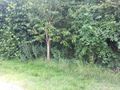
| − | Image:2014-07- | + | Image:2014-07-12_51_-0_D.jpg | It wasn't as overgrown as I'd thought, until I got close to the fence |
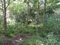
| − | Image:2014-07- | + | Image:2014-07-12_51_-0_E.jpg | Leaning forwards and reaching over at full stretch, I could just-about reach the hashpoint |
| + | Image:2014-07-12_51_-0_F.jpg | Almost... just a few... more... | ||
| + | Image:2014-07-12_51_-0_G.jpg | ...there! A full stretch through some awfully prickly bushes, but I made it. | ||
</gallery> | </gallery> | ||
| − | |||
== Achievements == | == Achievements == | ||
| Line 44: | Line 50: | ||
[[Category:Expeditions]] | [[Category:Expeditions]] | ||
| + | [[Category:Coordinates reached]] | ||
<!-- [[Category:Expeditions with photos]] | <!-- [[Category:Expeditions with photos]] | ||
[[Category:Coordinates not reached]] | [[Category:Coordinates not reached]] | ||
[[Category:Not reached - No public access]] --> | [[Category:Not reached - No public access]] --> | ||
| + | {{location|GB|ENG|BKM}} | ||
Latest revision as of 00:42, 15 August 2019
|
Dan Q also wrote about this expedition on his blog. For more details and higher-resolution pictures, see this expedition's log at https://danq.me/2014/07/12/geohashing-expedition-2014-07-12-51-0/ |
| Sat 12 Jul 2014 in 51,-0: 51.7788637, -0.8703109 geohashing.info google osm bing/os kml crox |
Location
On the edge of a field near the village of Ford, outside Aylesbury.
Participants
Plans
I'm out in Aylesbury today, so I'll probably swing by the hashpoint late-morning/early afternoon, by car. Hopefully it's possible to get to it without climbing through any hedges!
Expedition
I was in Aylesbury this morning for an interview, and I'd discovered last night that a hashpoint had appeared pretty-much right between my home and the place I was visiting. It was off the major roads by a little way, but the day was beautiful and I relished the opportunity to go for an explore, by ZipCar and on foot. And that's exactly what I got.
After driving through the village of Ford, I came to the end of a road and the beginning of a private driveway, and found a place to park. The locals looked at me strangely as I found my bearings and set off up a bridleway. Suddenly, I realised that the hashpoint was off to my right somewhere, so I hacked my way through some trees to get closer to it. The hashpoint turned out to be pretty-much exactly on the spot of a tree, at the edge of a field. Sadly, the tree was on the otherside of a barbed wire fence, covered in vines, but I was (with some effort) able to lean far over to "touch" the hashpoint-tree, as shown in the photos.
Later, I got stuck in traffic and almost delivered the ZipCar back late, but just barely made it, vacating the car just as the (very prompt) next occupiers turned up. Phew!
Photos
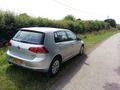
ZipCar "Seashell", my trusty ride for today's expedition
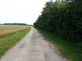
I parked as close as I could before the start of a private road, and took a nearby footpath
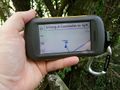
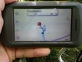
"Turn right here", my GPSr advised, to my horror
It wasn't as overgrown as I'd thought, until I got close to the fence

Leaning forwards and reaching over at full stretch, I could just-about reach the hashpoint
Almost... just a few... more...
...there! A full stretch through some awfully prickly bushes, but I made it.


