Difference between revisions of "2014-08-04 52 0"
imported>Sourcerer (An expedition message sent via Geohash Droid for Android.) |
imported>FippeBot m (Location) |
||
| (7 intermediate revisions by one other user not shown) | |||
| Line 1: | Line 1: | ||
| − | |||
| − | |||
| − | |||
| − | |||
| − | |||
| − | |||
| − | |||
| − | |||
| − | |||
| − | |||
{{meetup graticule | {{meetup graticule | ||
| − | | lat=52 | + | | lat=52 |
| − | | lon=0 | + | | lon=0 |
| − | | date=2014-08-04 | + | | date=2014-08-04 |
| + | | graticule_name=Cambridge, UK | ||
| + | | graticule_link=Cambridge, United Kingdom | ||
}} | }} | ||
| − | |||
| − | |||
__NOTOC__ | __NOTOC__ | ||
== Location == | == Location == | ||
| − | + | ||
| + | In a wild life haven close to the life boat station at Wells Next The Sea, Norfolk, UK. | ||
== Participants == | == Participants == | ||
| − | |||
| − | |||
| − | + | [[User:Sourcerer|Sourcerer]] | |
| − | |||
== Expedition == | == Expedition == | ||
| − | |||
| − | == | + | *Arrived. -- [[User:Sourcerer|Sourcerer]] ([[User talk:Sourcerer|talk]]) [http://www.openstreetmap.org/?lat=52.97232985&lon=.83900571&zoom=16&layers=B000FTF @52.9723,.8390] 16:05, 4 August 2014 (EDT) |
| − | |||
| − | + | This was an easy one. The destination was close to a car park and on a footpath, little used, but easily followed. Having a pathological aversion to paying for parking and as the car park gates get locked at dusk, Sourcerer parked about 2km away, in Wells, and walked back to the hashpoint arriving just after sunset. This was so easy to reach and in a seaside resort, it was a disappointment not to find an XKCD marker at the destination. | |
| − | |||
| − | |||
| − | |||
| − | |||
| − | |||
| − | + | The expedition was fun though. At the Wells end of the walk there was a DJ was working a crowd with music from a decade ago. Quite up to date for Norfolk and right up my street. Nearer the hashpoint, the rave sounds faded away, replaced by jet engines from RAF Marham or one of the other local air force bases. In the gaps, sea birds could be heard. | |
| − | |||
| − | |||
| + | There was a half moon waxing, adding to the atmosphere. | ||
| − | + | == Photos == | |
| − | |||
| − | |||
| − | < | + | <gallery perrow="5"> |
| + | Image:2014-08-04_52_0_21-06-04-181.jpg | Proof. [http://www.openstreetmap.org/?lat=52.97231913&lon=.83898962&zoom=16&layers=B000FTF @52.9723,.8390] | ||
| + | Image:2014-08-04_52_0_Sourcerer_1.jpg | Sunset near the Hashpoint | ||
| + | Image:2014-08-04_52_0_Sourcerer_2.jpg | Half Moon at the Hashpoint | ||
| + | </gallery> | ||
| − | + | {{Sourcerer_links | |
| − | + | | prev = 2014-06-29 52 0 | |
| − | + | | curr = 2014-08-04 52 0 | |
| − | -- | + | | next = 2014-08-12 52 1 |
| + | | date = 2014-08-04 | ||
| + | }} | ||
| − | |||
[[Category:Expeditions]] | [[Category:Expeditions]] | ||
| − | |||
[[Category:Expeditions with photos]] | [[Category:Expeditions with photos]] | ||
| − | |||
| − | |||
| − | |||
| − | |||
| − | |||
[[Category:Coordinates reached]] | [[Category:Coordinates reached]] | ||
| − | + | {{location|GB|ENG|NFK}} | |
| − | |||
| − | |||
| − | |||
| − | |||
| − | |||
| − | |||
| − | |||
| − | |||
| − | |||
| − | |||
| − | |||
| − | |||
| − | |||
| − | |||
| − | |||
| − | |||
| − | |||
Latest revision as of 00:57, 15 August 2019
| Mon 4 Aug 2014 in Cambridge, UK: 52.9723167, 0.8389808 geohashing.info google osm bing/os kml crox |
Location
In a wild life haven close to the life boat station at Wells Next The Sea, Norfolk, UK.
Participants
Expedition
- Arrived. -- Sourcerer (talk) @52.9723,.8390 16:05, 4 August 2014 (EDT)
This was an easy one. The destination was close to a car park and on a footpath, little used, but easily followed. Having a pathological aversion to paying for parking and as the car park gates get locked at dusk, Sourcerer parked about 2km away, in Wells, and walked back to the hashpoint arriving just after sunset. This was so easy to reach and in a seaside resort, it was a disappointment not to find an XKCD marker at the destination.
The expedition was fun though. At the Wells end of the walk there was a DJ was working a crowd with music from a decade ago. Quite up to date for Norfolk and right up my street. Nearer the hashpoint, the rave sounds faded away, replaced by jet engines from RAF Marham or one of the other local air force bases. In the gaps, sea birds could be heard.
There was a half moon waxing, adding to the atmosphere.
Photos
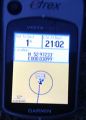
Proof. @52.9723,.8390
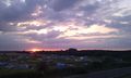
Sunset near the Hashpoint
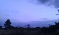
Half Moon at the Hashpoint


Expeditions and Plans
| 2014-08-04 | ||
|---|---|---|
| Cambridge, United Kingdom | Sourcerer | In a wild life haven close to the life boat station at Wells Next The Sea, ... |
| Hannover, Germany | GeorgDerReisende | The hash lay on a fieldway near Soltau-Tetendorf. |
Sourcerer's Expedition Links
2014-06-29 52 0 - 2014-08-04 52 0 - 2014-08-12 52 1 - KML file download of Sourcerer's expeditions for use with Google Earth.