Difference between revisions of "2014-08-08 48 11"
imported>TheOneRing (Created page with "{{meetup graticule | lat=48 | lon=11 | date=2014-08-08 }} == Location == The geohash is on a field next to the "Sonderflughafen Oberpfaffenhofen" (a small airport). == Who W...") |
imported>FippeBot m (Location) |
||
| (One intermediate revision by one other user not shown) | |||
| Line 31: | Line 31: | ||
Image:20140808_47_11Surrounding.jpg|A view over the fields | Image:20140808_47_11Surrounding.jpg|A view over the fields | ||
Image:20140808_47_11Easy.jpg|Reaching the geohash after 3km by bike = easy | Image:20140808_47_11Easy.jpg|Reaching the geohash after 3km by bike = easy | ||
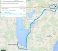
| + | Image:20140808_47_11Tour.jpg|The complete trip | ||
</gallery> | </gallery> | ||
| Line 41: | Line 42: | ||
[[Category:Expeditions with photos]] | [[Category:Expeditions with photos]] | ||
[[Category:Coordinates reached]] | [[Category:Coordinates reached]] | ||
| + | {{location|DE|BY|STA}} | ||
Latest revision as of 00:58, 15 August 2019
| Fri 8 Aug 2014 in 48,11: 48.0901767, 11.3112848 geohashing.info google osm bing/os kml crox |
Location
The geohash is on a field next to the "Sonderflughafen Oberpfaffenhofen" (a small airport).
Who Went
TheOneRing - by bike.
The Expedition
Darn, the geohash was so close to my office it would nearly qualify to go for the Cubicle geohash achievement. Too bad it was approx. 2.3km away...but still an Easy Geohash.
Every now and then I go to work by bike, 27km one-way afterall. Yeah I know, big deal, but I'm not really used to go more than 50km by bike on a working day.
Ok, back to the story: After I saw that the geohash is really close to my office, I left the office to pass the geohash on my way back home. Next to the geohash, there is the "Sonderflughafen Oberpfaffenhofen", a small airport. There, airplanes start and land, and the facility is used for aeronautical tests. Unfortunately, I hadn't had my camera ready when some planes were starting, so no photographs. I parked my bike on a dirt road and walked the final 200m over harvested fields.
I took the usual photos, amongst others a nice panoramic view and walked back to my bike and started my way home.
This was a really nice trip, although I made a detour of about 10km. Of course, you have to award yourself for such a trip: with approx. 8km to go there is a small lido with a snack bar. There, I had a small rest with and drank a "Radler". You may translate it into "biker", as it is a drink created for bikers: half beer, half lemonade (mostly Sprite-like).
Photos
Achievements
TheOneRing earned the Land geohash achievement
|
TheOneRing earned the Bicycle geohash achievement
|
TheOneRing has visited an Easy Geohash
|


