Difference between revisions of "2014-12-25 51 -0"
From Geohashing
imported>Benjw (create expedition page) |
imported>Benjw (everything but the expedition report) |
||
| Line 1: | Line 1: | ||
| − | + | [[Image:2014-12-25 51 -0 cathedral.jpg|thumb|left]] | |
| − | |||
| − | |||
| − | [[Image: | ||
| − | |||
| − | |||
| − | |||
| − | |||
| − | |||
| − | |||
{{meetup graticule | {{meetup graticule | ||
| lat=51 | | lat=51 | ||
| lon=-0 | | lon=-0 | ||
| − | | date= | + | | date=2014-12-25 |
}} | }} | ||
| − | |||
| − | |||
| − | |||
== Location == | == Location == | ||
| − | + | In woodland between Wanborough and Christmas Pie, west of Guildford, Surrey. | |
== Participants == | == Participants == | ||
| − | + | * [[User:Benjw|Benjw]] | |
| − | |||
| − | |||
| − | |||
| − | |||
== Expedition == | == Expedition == | ||
<!-- how it all turned out. your narrative goes here. --> | <!-- how it all turned out. your narrative goes here. --> | ||
| − | |||
| − | |||
| − | |||
== Photos == | == Photos == | ||
| − | |||
| − | |||
| − | |||
<gallery perrow="5"> | <gallery perrow="5"> | ||
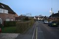
| + | Image:2014-12-25 51 -0 setting off.jpg | An early-morning expedition | ||
| + | Image:2014-12-25 51 -0 cathedral sunrise.jpg | Guildford Cathedral from the west | ||
| + | Image:2014-12-25 51 -0 wanborough.jpg | Through the village of Wanborough | ||
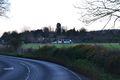
| + | Image:2014-12-25 51 -0 christmas pie.jpg | I turned round in Christmas Pie | ||
| + | Image:2014-12-25 51 -0 entering woods.jpg | A path was handily placed for me | ||
| + | Image:2014-12-25 51 -0 woods track.jpg | A wide track was also handy | ||
| + | Image:2014-12-25 51 -0 gps.jpg | Hashpoint found! | ||
| + | Image:2014-12-25 51 -0 hasher.jpg | Hasher with holly and ivy | ||
| + | Image:2014-12-25 51 -0 hashpoint.jpg | The view: more woods | ||
| + | Image:2014-12-25 51 -0 cathedral.jpg | The cathedral again on the way home | ||
</gallery> | </gallery> | ||
== Achievements == | == Achievements == | ||
| + | Only the one: | ||
| + | |||
{{#vardefine:ribbonwidth|800px}} | {{#vardefine:ribbonwidth|800px}} | ||
| − | + | {{land geohash | |
| − | + | | latitude = 51 | |
| − | + | | longitude = -0 | |
| − | + | | date = 2014-12-25 | |
| − | + | | name = [[User:Benjw|Benjw]] | |
| − | [[ | + | | image = 2014-12-25 51 -0 hasher.jpg |
| − | + | }} | |
| − | |||
| − | |||
| − | |||
| − | |||
| − | |||
| − | |||
| − | |||
[[Category:Expeditions]] | [[Category:Expeditions]] | ||
| − | |||
[[Category:Expeditions with photos]] | [[Category:Expeditions with photos]] | ||
| − | |||
| − | |||
| − | |||
| − | |||
| − | |||
[[Category:Coordinates reached]] | [[Category:Coordinates reached]] | ||
| − | |||
| − | |||
| − | |||
| − | |||
| − | |||
| − | |||
| − | |||
| − | |||
| − | |||
| − | |||
| − | |||
| − | |||
| − | |||
| − | |||
| − | |||
| − | |||
| − | |||
| − | |||
Revision as of 11:06, 25 December 2014

| Thu 25 Dec 2014 in 51,-0: 51.2358031, -0.6704015 geohashing.info google osm bing/os kml crox |
Location
In woodland between Wanborough and Christmas Pie, west of Guildford, Surrey.
Participants
Expedition
Photos
An early-morning expedition
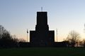
Guildford Cathedral from the west
Through the village of Wanborough
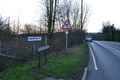
I turned round in Christmas Pie

A path was handily placed for me
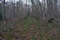
A wide track was also handy

Hashpoint found!
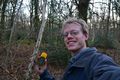
Hasher with holly and ivy
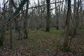
The view: more woods
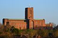
The cathedral again on the way home


Achievements
Only the one:
Benjw earned the Land geohash achievement
|