Difference between revisions of "2014-12-25 51 -0"
imported>Benjw m (→Expedition: typo) |
imported>Benjw m (better section headings) |
||
| Line 22: | Line 22: | ||
After a few photos, I walked back to the car. Apart from a quick diversion into Wanborough for another geocache, I then drove straight back home to help with Christmas lunch. | After a few photos, I walked back to the car. Apart from a quick diversion into Wanborough for another geocache, I then drove straight back home to help with Christmas lunch. | ||
| − | == | + | == Photographic documentation == |
<gallery perrow="5"> | <gallery perrow="5"> | ||
Image:2014-12-25 51 -0 setting off.jpg | An early-morning expedition | Image:2014-12-25 51 -0 setting off.jpg | An early-morning expedition | ||
| Line 36: | Line 36: | ||
</gallery> | </gallery> | ||
| − | == | + | == Shiny ribbons earned == |
| − | Only the one: | + | Only the usual one today: |
{{#vardefine:ribbonwidth|800px}} | {{#vardefine:ribbonwidth|800px}} | ||
{{land geohash | {{land geohash | ||
Revision as of 09:13, 13 February 2015

| Thu 25 Dec 2014 in 51,-0: 51.2358031, -0.6704015 geohashing.info google osm bing/os kml crox |
Location
In woodland between Wanborough and Christmas Pie, west of Guildford, Surrey.
Participants
Expedition
MrsBenjw and I are staying with her family for Christmas, in Guildford. I habitually get up very early, but it appears they don't, so I popped out for a morning's geohashing and caching expedition. I'd seen, the previous evening, that the hashpoint was a mere 5.25 km from the house, so it was nice to get out for a nice easy trip. The weather was lovely, too: chilly, but clear and sunny.
It was a little too far to walk in the time available, so I drove, calling in at Guildford Cathedral for a photo on the way. The village of Wanborough was easily found (I used to live around here, so I know the roads quite well), but I couldn't find a safe parking spot, so I drove on to the next village to turn round. This village turned out to be called Christmas Pie, which was very apt today. I stopped for a quick geocache and then turned back towards the hashpoint.
I parked in a small lay-by just past the hash, and walked along the road. There was little traffic today. At about the point when the road came closest to the hashpoint, I found a convenient path to take, which turned into a wide, clear strip through the woods; probably an old vehicle track. This came within 30 meters of the hashpoint, and the woods were quite sparse, so I found it quite easily, and didn't even get muddy shoes (which was good, because I'd forgotten to bring any spare shoes with me for our few days away).
I was particularly pleased to note the presence of both holly and ivy at the hashpoint, which along with Christmas Pie made it a very suitable hashpoint for Christmas Day.
After a few photos, I walked back to the car. Apart from a quick diversion into Wanborough for another geocache, I then drove straight back home to help with Christmas lunch.
Photographic documentation

An early-morning expedition
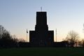
Guildford Cathedral from the west
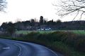
Through the village of Wanborough
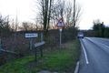
I turned round in Christmas Pie
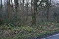
A path was handily placed for me
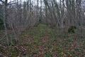
A wide track was also handy
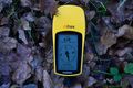
Hashpoint found!

Hasher with holly and ivy
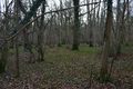
The view: more woods

The cathedral again on the way home


Shiny ribbons earned
Only the usual one today:
Benjw earned the Land geohash achievement
|