Difference between revisions of "2015-01-23 -35 174"
imported>Jacksonz m (→Expedition: Fixed speeling mistake) |
imported>Jacksonz m (→Photos: Fix case in file names) |
||
| Line 21: | Line 21: | ||
== Photos == | == Photos == | ||
<gallery perrow="4"> | <gallery perrow="4"> | ||
| − | File:Geohash_20150123_Possum. | + | File:Geohash_20150123_Possum.JPG | Dead Possum found nearby |
| − | File: | + | File:Geohash 20150123 East.JPG | View to the East |
| − | File: | + | File:Geohash 20150123 South.JPG | View to the South |
| − | File: | + | File:Geohash 20150123 West.JPG | View to the West |
| − | File: | + | File:Geohash 20150123 North.JPG | View to the North |
| − | File: | + | File:Geohash 20150123 Up.JPG | View upwards |
| − | File: | + | File:Geohash 20150123 GPS.JPG | At the Location at midday |
| − | File: | + | File:Geohash 20150123 Us.JPG | Jacksonz |
| − | File: | + | File:Geohash 20150123 back.JPG | Heading back to the road |
</gallery> | </gallery> | ||
| − | |||
[[Category:Expeditions]] | [[Category:Expeditions]] | ||
[[Category:Expeditions with photos]] | [[Category:Expeditions with photos]] | ||
[[Category:Coordinates reached]] | [[Category:Coordinates reached]] | ||
Revision as of 05:07, 31 January 2015
| Fri 23 Jan 2015 in -35,174: -35.7415517, 174.4216344 geohashing.info google osm bing/os kml crox |
Contents
Location
Farmland off Owhiwa Rd, Parua Bay, Northland
Participants
Plans
We stayed at the Kauri Villas B&B on Owhiwa Rd for the previous two nights while celebrating our 20th Wedding Anniversary. On the day of our departure we were planning to visit Abbey Caves by driving up Owhiwa Rd, and over Mt Tiger. On checking the geohash in the morning, I was astounded to see that it was about 50m off the road that we would be driving along, in a small piece of bush. Decided to try and visit it if possible.
Expedition
Arrived near to the location, and spied a nearby farmhouse. Parked on the road outside and wandered in the drive. Found the landowner, Alan Cooke, wondering why his donkeys were so agitated - they make great guard dogs apparently. Explained geohashing to him, and he readily agreed that it was fine for us to enter his land to get to the location. He stated that it was possible it was just on the next door neighbour's land but he was sure that she would have no problem with it either.
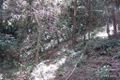
We walked down the road, and crossed a fence into a field, which we crossed in single file towards the location. Once under the trees the phone had real problems with locating satellites, sending us this way and that, and never settling down. We came across two poisoned possums, which are noxious pests in New Zealand. By using the phone out of the tree cover on either side of the bush, and by transferring the co-ordinates to the GPS, we got to the vicinity of the Geohash. Neither the phone nor GPS settled exactly on the co-ordinates, but after shuffling around for about 10 minutes we decided that at least one of us at some point must have been at the location, so took a set of photographs before departing.
Photos

Dead Possum found nearby
View to the East
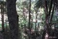
View to the South
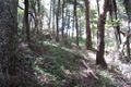
View to the West
View to the North
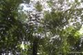
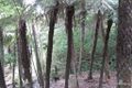
View upwards
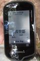
At the Location at midday
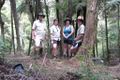
Jacksonz
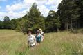
Heading back to the road


