Difference between revisions of "2015-02-13 52 -1"
From Geohashing
imported>Sourcerer (An expedition message sent via Geohash Droid for Android.) |
imported>FippeBot m (Location) |
||
| (8 intermediate revisions by one other user not shown) | |||
| Line 1: | Line 1: | ||
| − | |||
| − | |||
| − | |||
| − | |||
| − | |||
| − | |||
| − | |||
| − | |||
| − | |||
| − | |||
{{meetup graticule | {{meetup graticule | ||
| lat=52 | | lat=52 | ||
| lon=-1 | | lon=-1 | ||
| date=2015-02-13 | | date=2015-02-13 | ||
| + | | graticule_name=Birmingham, UK | ||
| + | | graticule_link=Birmingham, United Kingdom | ||
}} | }} | ||
| − | |||
| − | |||
__NOTOC__ | __NOTOC__ | ||
== Location == | == Location == | ||
| − | + | ||
| + | 3) In a technology park where the M1 crosses the A52, between Nottingham and Derby, Derbyshire, UK. | ||
== Participants == | == Participants == | ||
| − | |||
| − | |||
| − | + | [[User:Sourcerer|Sourcerer]] | |
| − | |||
== Expedition == | == Expedition == | ||
| − | |||
| − | == | + | *Arrived. -- [[User:Sourcerer|Sourcerer]] ([[User talk:Sourcerer|talk]]) [http://www.openstreetmap.org/?lat=52.91773081&lon=-1.30142391&zoom=16&layers=B000FTF @52.9177,-1.3014] 16:18, 13 February 2015 (GMT) |
| − | + | ||
| + | This was hash three of a triple [[2015-02-13 52 1]] :: [[2015-02-13 52 -0]] :: [[2015-02-13 52 -1]] | ||
| + | |||
| + | It was in the car park behind a gate, presumably locked at night. My excuse for entering the private zone was the Motel label on my map. I was "lost". I got close enough and did not bother to get out of the car to zero the distance. This was almost a "couch potato" because it was so close to my route and I did not need to stand up or walk to claim the point. | ||
== Photos == | == Photos == | ||
| − | + | ||
| − | |||
| − | |||
<gallery perrow="5"> | <gallery perrow="5"> | ||
| + | Image:2015-02-13_52_-1_Sourcerer_1423844211124.jpg | [http://www.openstreetmap.org/?lat=52.91773081&lon=-1.30142927&zoom=16&layers=B000FTF @52.9177,-1.3014] | ||
| + | Image:2015-02-13 52 -1 Sourcerer 2.jpg | View from the Hashpoint | ||
</gallery> | </gallery> | ||
== Achievements == | == Achievements == | ||
{{#vardefine:ribbonwidth|800px}} | {{#vardefine:ribbonwidth|800px}} | ||
| − | |||
| + | {{Multihash2 | ||
| + | | date = 2015-02-13 | ||
| + | | count = 3 | ||
| + | | name = Sourcerer | ||
| + | }} | ||
| − | + | {{Sourcerer_links | |
| − | + | | prev = 2015-02-13 52 -0 | |
| − | + | | curr = 2015-02-13 52 -1 | |
| − | + | | next = 2015-02-15 52 -0 | |
| − | + | | date = 2015-02-13 | |
| − | + | }} | |
| − | |||
| − | |||
| − | |||
| − | |||
| − | |||
[[Category:Expeditions]] | [[Category:Expeditions]] | ||
| − | |||
[[Category:Expeditions with photos]] | [[Category:Expeditions with photos]] | ||
| − | |||
| − | |||
| − | |||
| − | |||
| − | |||
[[Category:Coordinates reached]] | [[Category:Coordinates reached]] | ||
| − | + | {{location|GB|ENG|DBY}} | |
| − | |||
| − | |||
| − | |||
| − | |||
| − | |||
| − | |||
| − | |||
| − | |||
| − | |||
| − | |||
| − | |||
| − | |||
| − | |||
| − | |||
| − | |||
| − | |||
| − | |||
Latest revision as of 02:43, 15 August 2019
| Fri 13 Feb 2015 in Birmingham, UK: 52.9176924, -1.3014347 geohashing.info google osm bing/os kml crox |
Location
3) In a technology park where the M1 crosses the A52, between Nottingham and Derby, Derbyshire, UK.
Participants
Expedition
- Arrived. -- Sourcerer (talk) @52.9177,-1.3014 16:18, 13 February 2015 (GMT)
This was hash three of a triple 2015-02-13 52 1 :: 2015-02-13 52 -0 :: 2015-02-13 52 -1
It was in the car park behind a gate, presumably locked at night. My excuse for entering the private zone was the Motel label on my map. I was "lost". I got close enough and did not bother to get out of the car to zero the distance. This was almost a "couch potato" because it was so close to my route and I did not need to stand up or walk to claim the point.
Photos
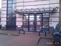
View from the Hashpoint


Achievements
Sourcerer earned the Multihash Achievement
|
Expeditions and Plans
| 2015-02-13 | ||
|---|---|---|
| Schweinfurt, Germany | GeorgDerReisende | The hash lies on a meadow in Wilhelmsthal near Eisenach. 53.5 meters away f... |
| Erfurt, Germany | crissar, Reinhard | The hash lies near Hengstbachhof located in Hetschburg. |
| Northampton, United Kingdom | Sourcerer | 2) In a field north of the A52 trunk road north east of Horbling, Lincolnsh... |
| Birmingham, United Kingdom | Sourcerer | 3) In a technology park where the M1 crosses the A52, between Nottingham an... |
| Norwich, United Kingdom | Sourcerer | 1) On the Cromer to Norwich railway line just east of Roughton Road station... |
Sourcerer's Expedition Links
2015-02-13 52 -0 - 2015-02-13 52 -1 - 2015-02-15 52 -0 - KML file download of Sourcerer's expeditions for use with Google Earth.