Difference between revisions of "2015-02-22 52 1"
From Geohashing
imported>Sourcerer m ([live picture] Proof. [http://www.openstreetmap.org/?lat=52.89864957&lon=1.04069173&zoom=16&layers=B000FTF @52.8986,1.0407]) |
imported>Sourcerer m (→New expedition) |
||
| Line 17: | Line 17: | ||
Planning two hashpoints spanning midnight: [[2015-02-21 52 1]] :: [[2015-02-22 52 1]] | Planning two hashpoints spanning midnight: [[2015-02-21 52 1]] :: [[2015-02-22 52 1]] | ||
| + | *Arrived. -- [[User:Sourcerer|Sourcerer]] ([[User talk:Sourcerer|talk]]) [http://www.openstreetmap.org/?lat=52.89864421&lon=1.04069173&zoom=16&layers=B000FTF @52.8986,1.0407] 00:01, 22 February 2015 (GMT) | ||
| + | |||
| + | This was becoming routine being the 9th consecutive expedition. Park the car. Walk along the field perimeter to get as close as possible. Divert into the field avoiding the crop (oil seed rape seedlings). Wait for midnight and get the evidence photo. Today the Garmin and HTC devices disagreed on the location by about 12 or 15 metres. I zeroed both devices to be sure. | ||
| + | |||
| + | The Norwich graticule has been creeping up the activity ratings this month. It's not easy to outperform other graticules with 43% ocean and only 28 days in the month. It's fun though! | ||
| − | |||
== Photos == | == Photos == | ||
<gallery perrow="5"> | <gallery perrow="5"> | ||
| − | |||
Image:2015-02-22_52_1_Sourcerer_1424563200655.jpg | Proof. [http://www.openstreetmap.org/?lat=52.89864957&lon=1.04069173&zoom=16&layers=B000FTF @52.8986,1.0407] | Image:2015-02-22_52_1_Sourcerer_1424563200655.jpg | Proof. [http://www.openstreetmap.org/?lat=52.89864957&lon=1.04069173&zoom=16&layers=B000FTF @52.8986,1.0407] | ||
| + | Image:2015-02-22_52_1_Sourcerer_2.jpg | Track Log | ||
</gallery> | </gallery> | ||
| Line 29: | Line 33: | ||
{{#vardefine:ribbonwidth|800px}} | {{#vardefine:ribbonwidth|800px}} | ||
| − | |||
{{consecutive geohash 2 | {{consecutive geohash 2 | ||
| − | | count = | + | | count = 8 |
| latitude = 52 | | latitude = 52 | ||
| longitude = 1 | | longitude = 1 | ||
| date = 2015-02-15 | | date = 2015-02-15 | ||
| + | | name = Sourcerer | ||
| + | }} | ||
| + | {{Midnight geohash | ||
| + | | latitude = 52 | ||
| + | | longitude = 1 | ||
| + | | date = 2015-02-22 | ||
| name = Sourcerer | | name = Sourcerer | ||
}} | }} | ||
| − | |||
== Other geohashing expeditions on the same day == | == Other geohashing expeditions on the same day == | ||
{{expedition summaries|2015-02-22}} | {{expedition summaries|2015-02-22}} | ||
| − | |||
| − | |||
| − | |||
[[Category:Expeditions]] | [[Category:Expeditions]] | ||
[[Category:Expeditions with photos]] | [[Category:Expeditions with photos]] | ||
[[Category:Coordinates reached]] | [[Category:Coordinates reached]] | ||
| − | |||
Revision as of 01:56, 22 February 2015
| Sun 22 Feb 2015 in 52,1: 52.8986501, 1.0406906 geohashing.info google osm bing/os kml crox |
Location
In a field close to the A148, west of Holt and Letheringsett, Norfolk, UK.
Participants
Expedition
Planning two hashpoints spanning midnight: 2015-02-21 52 1 :: 2015-02-22 52 1
- Arrived. -- Sourcerer (talk) @52.8986,1.0407 00:01, 22 February 2015 (GMT)
This was becoming routine being the 9th consecutive expedition. Park the car. Walk along the field perimeter to get as close as possible. Divert into the field avoiding the crop (oil seed rape seedlings). Wait for midnight and get the evidence photo. Today the Garmin and HTC devices disagreed on the location by about 12 or 15 metres. I zeroed both devices to be sure.
The Norwich graticule has been creeping up the activity ratings this month. It's not easy to outperform other graticules with 43% ocean and only 28 days in the month. It's fun though!
Photos
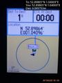
Proof. @52.8986,1.0407
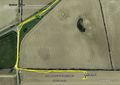
Track Log


Achievements
Sourcerer earned the Consecutive geohash achievement
|
Sourcerer earned the Midnight Geohash achievement
|
Other geohashing expeditions on the same day
Expeditions and Plans
| 2015-02-22 | ||
|---|---|---|
| Eugene, Oregon | Frogman | A strip mall parking lot in Salem, Oregon. |
| Pforzheim, Germany | DODO | In the forest (or a fern-filed) south of Niederroedern. |
| Praha, Czech Republic | Danatar | in a meadow near Leupoldshain, a part of the municipality of Königstein (Sä... |
| Canterbury, United Kingdom | Sourcerer | 2) In a field north of Great Bromley and Little Bentley, Essex, UK. |
| Rotterdam, Netherlands | FelixTheCat | On the beach outside Oostvoorne, The Netherlands |
| Norwich, United Kingdom | Sourcerer | 1) In a field close to the A148, west of Holt and Letheringsett, Norfolk, U... |