Difference between revisions of "2015-04-08 47 -122"
imported>Thomcat ([live picture] [http://www.openstreetmap.org/?lat=47.79540045&lon=-122.17307539&zoom=16&layers=B000FTF @47.7954,-122.1731]) |
imported>Thomcat (details and photo notes) |
||
| Line 18: | Line 18: | ||
== Expedition == | == Expedition == | ||
| − | First driveby reveals the path open and accessible. One of the two houses at the end of the drive seems to have been for sale recently and is "pending" according to [http://www.zillow.com/homedetails/21510-45th-Ave-SE-Bothell-WA-98021/38459760_zpid/ Zillow]. | + | First driveby reveals the path open and accessible. One of the two houses at the end of the drive seems to have been for sale recently and is "pending" according to [http://www.zillow.com/homedetails/21510-45th-Ave-SE-Bothell-WA-98021/38459760_zpid/ Zillow]. |
| + | |||
| + | During the drive out, I noticed several bright orange Notice of Land Use signs, so on my return journey I vowed to check one of these out. | ||
| + | |||
| + | My return journey was shortly after 2pm, and I was in a hurry. I drove down the lane in question and parked at the "sold" house, which looks abandoned. Trees and wires conspired to keep the satellite coordinates jumping, but I reached the location by a fence. There was also an unusual wire mesh I took a photo of - the backing of a sign perhaps? A high-in-the-air ivy trellis? Not sure. | ||
| + | |||
| + | Exiting the lot, I found a sign - lovingly decorated with a grim reaper, vulture, and a shrouded flamingo. It turns out that this land has been purchased by the [https://fortress.wa.gov/ecy/separ/Register/ShowRegister.aspx?Register=118741 The Grove at Canyon Park] which is going to turn the four or five wooded parcels into a 53 unit subdivision. From the zillow records above, it looks like the owner of this lot did okay - what was once worth 350k sold for nearly 800k. The house looks nice and it is a shame to tear it down, though. | ||
== Tracklog == | == Tracklog == | ||
| Line 29: | Line 35: | ||
<gallery perrow="5"> | <gallery perrow="5"> | ||
| − | Image:2015-04-08_47_-122_thomcat_1428506534986.jpg | [http://www.openstreetmap.org/?lat=47.80206371&lon=-122.17313674&zoom=16&layers=B000FTF @47.8021,-122.1731] | + | Image:2015-04-08_47_-122_thomcat_1428506534986.jpg | [http://www.openstreetmap.org/?lat=47.80206371&lon=-122.17313674&zoom=16&layers=B000FTF @47.8021,-122.1731] The driveway in question |
| − | Image:2015-04-08_47_-122_thomcat_1428527356667.jpg | [http://www.openstreetmap.org/?lat=47.80225232&lon=-122.17432079&zoom=16&layers=B000FTF @47.8023,-122.1743] | + | Image:2015-04-08_47_-122_thomcat_1428527356667.jpg | [http://www.openstreetmap.org/?lat=47.80225232&lon=-122.17432079&zoom=16&layers=B000FTF @47.8023,-122.1743] Likely abandoned house |
Image:2015-04-08_47_-122_thomcat_1428527408351.jpg | [http://www.openstreetmap.org/?lat=47.80220456&lon=-122.17395996&zoom=16&layers=B000FTF @47.8022,-122.1740] | Image:2015-04-08_47_-122_thomcat_1428527408351.jpg | [http://www.openstreetmap.org/?lat=47.80220456&lon=-122.17395996&zoom=16&layers=B000FTF @47.8022,-122.1740] | ||
| − | Image:2015-04-08_47_-122_thomcat_1428527552248.jpg | [http://www.openstreetmap.org/?lat=47.80223815&lon=-122.17394867&zoom=16&layers=B000FTF @47.8022,-122.1739] | + | Image:2015-04-08_47_-122_thomcat_1428527552248.jpg | [http://www.openstreetmap.org/?lat=47.80223815&lon=-122.17394867&zoom=16&layers=B000FTF @47.8022,-122.1739] Unusual structure |
| − | Image:2015-04-08_47_-122_thomcat_1428527769884.jpg | [http://www.openstreetmap.org/?lat=47.79540045&lon=-122.17307539&zoom=16&layers=B000FTF @47.7954,-122.1731] | + | Image:2015-04-08_47_-122_thomcat_1428527769884.jpg | [http://www.openstreetmap.org/?lat=47.79540045&lon=-122.17307539&zoom=16&layers=B000FTF @47.7954,-122.1731] The death of greenspace |
</gallery> | </gallery> | ||
| Line 43: | Line 49: | ||
{{#vardefine:ribbonwidth|800px}} | {{#vardefine:ribbonwidth|800px}} | ||
<!-- Add any achievement ribbons you earned below, or remove this section --> | <!-- Add any achievement ribbons you earned below, or remove this section --> | ||
| − | |||
[[Category:Expeditions]] | [[Category:Expeditions]] | ||
[[Category:Expeditions with photos]] | [[Category:Expeditions with photos]] | ||
| − | |||
| − | |||
[[Category:Coordinates reached]] | [[Category:Coordinates reached]] | ||
| − | |||
| − | |||
| − | |||
| − | |||
| − | |||
| − | |||
| − | |||
| − | |||
| − | |||
| − | |||
| − | |||
| − | |||
| − | |||
| − | |||
| − | |||
| − | |||
| − | |||
Revision as of 13:56, 9 April 2015
| Wed 8 Apr 2015 in Seattle: 47.8021330, -122.1739523 geohashing.info google osm bing/os kml crox |
Location
A driveway in Canyon Park, Bothell.
Participants
Plans
Drive by before work, return about 2pm. Care to join me?
Expedition
First driveby reveals the path open and accessible. One of the two houses at the end of the drive seems to have been for sale recently and is "pending" according to Zillow.
During the drive out, I noticed several bright orange Notice of Land Use signs, so on my return journey I vowed to check one of these out.
My return journey was shortly after 2pm, and I was in a hurry. I drove down the lane in question and parked at the "sold" house, which looks abandoned. Trees and wires conspired to keep the satellite coordinates jumping, but I reached the location by a fence. There was also an unusual wire mesh I took a photo of - the backing of a sign perhaps? A high-in-the-air ivy trellis? Not sure.
Exiting the lot, I found a sign - lovingly decorated with a grim reaper, vulture, and a shrouded flamingo. It turns out that this land has been purchased by the The Grove at Canyon Park which is going to turn the four or five wooded parcels into a 53 unit subdivision. From the zillow records above, it looks like the owner of this lot did okay - what was once worth 350k sold for nearly 800k. The house looks nice and it is a shame to tear it down, though.
Tracklog
Photos
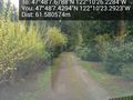
@47.8021,-122.1731 The driveway in question
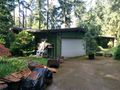
@47.8023,-122.1743 Likely abandoned house
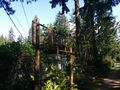
@47.8022,-122.1739 Unusual structure
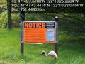
@47.7954,-122.1731 The death of greenspace


