Difference between revisions of "2013-02-23 42 -77"
From Geohashing
imported>HicSuntLaganum (→Expedition) |
imported>FippeBot m (Location) |
||
| Line 32: | Line 32: | ||
[[Category:Expeditions with photos]] | [[Category:Expeditions with photos]] | ||
[[Category:Coordinates reached]] | [[Category:Coordinates reached]] | ||
| + | {{location|US|NY|OR}} | ||
Latest revision as of 01:06, 14 August 2019
| Sat 23 Feb 2013 in Corning: 42.9267484, -77.2823594 geohashing.info google osm bing/os kml crox |
Contents
[hide]Location
Westbound on Emerson Rd
Participants
Expedition
- Hic Sunt Laganum
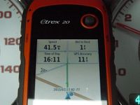
- We arrived to the point ahead of time so that we could scope it out. The bird's eye photos showed it to be very close to a stop sign and on the shoulder. The actual point happened to land a couple hundred feet up the road so would only be able to attempt a speed racer in one direction, we simply couldn't get enough speed and have a stable photo at the same time. We attempted to pass through the point at exactly 16:00 however traffic was not permitting. Angel food wanted to have another pass to see if he could get it a little closer and a couple tries later achieved the second photo.
Photos

The Hic Sunt Laganum GPS
The Hic Sunt Laganum GPS take two?


Achievements
HicSuntLaganum earned the Land geohash achievement
|
HicSuntLaganum earned the Speed racer achievement
|
HicSuntLaganum earned the Meet-up achievement
|