Difference between revisions of "2015-04-10 52 1"
From Geohashing
imported>Sourcerer m (→Links) |
imported>Sourcerer m (→Removed non record breaking consecutive achievements) |
||
| Line 28: | Line 28: | ||
== Achievements == | == Achievements == | ||
{{#vardefine:ribbonwidth|800px}} | {{#vardefine:ribbonwidth|800px}} | ||
| − | |||
| − | |||
| − | |||
| − | |||
| − | |||
| − | |||
| − | |||
{{Sourcerer_links | {{Sourcerer_links | ||
Revision as of 21:38, 18 August 2015
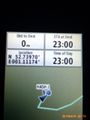
| Fri 10 Apr 2015 in 52,1: 52.7396959, 1.1117356 geohashing.info google osm bing/os kml crox |
Location
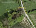
In a gated meadow, north of Lenwade, Norfolk, UK. The gate was open.
Participants
Expedition
This was expedition one of two spanning midnight - 2015-04-10 52 1 - 2015-04-11 52 1. The wiki appeared to be unavailable so my Droid phone arrival message failed.
There was a very convenient parking place and the hashpoint was a few steps, through the invitingly open gate, into the meadow.
Photos
Proof
Google Earth Track


Achievements
Expeditions and Plans
| 2015-04-10 | ||
|---|---|---|
| Fulda, Germany | GeorgDerReisende | The hash lies on the Hobertshäuser Berg near Ober-Gleen. |
| Norwich, United Kingdom | Sourcerer | In a gated meadow, north of Lenwade, Norfolk, UK. The gate was open. |
| Bielefeld, Germany | Jan, Fippe | located on a field near Hausstette. |
Sourcerer's Expedition Links
2015-04-09 52 1 - 2015-04-10 52 1 - 2015-04-11 52 1 - KML file download of Sourcerer's expeditions for use with Google Earth.