Difference between revisions of "2015-04-17 52 1"
From Geohashing
imported>Sourcerer m ([live picture] Proof. [http://www.openstreetmap.org/?lat=52.24029064&lon=1.45423472&zoom=16&layers=B000FTF @52.2403,1.4542]) |
imported>Sourcerer m (→New Expedition) |
||
| Line 16: | Line 16: | ||
== Expedition == | == Expedition == | ||
| − | + | This was be expedition two of two spanning midnight - [[2015-04-16 52 1]] - [[2015-04-17 52 1]] - The points were close together. | |
| + | *Arrived. -- [[User:Sourcerer|Sourcerer]] ([[User talk:Sourcerer|talk]]) [http://www.openstreetmap.org/?lat=52.24029064&lon=1.45423472&zoom=16&layers=B000FTF @52.2403,1.4542] 00:00, 17 April 2015 (GMT+01:00) | ||
| + | |||
| + | The field was bone dry and it looked as though seeds had been sown but not yet germinated. The sky was clear with many stars and no moon. There was a cold breeze and the temperature was 7 Celsius. | ||
| − | |||
== Photos == | == Photos == | ||
<gallery perrow="5"> | <gallery perrow="5"> | ||
Image:2015-04-17_52_1_Sourcerer_1429225149011.jpg | Proof. [http://www.openstreetmap.org/?lat=52.24029064&lon=1.45423472&zoom=16&layers=B000FTF @52.2403,1.4542] | Image:2015-04-17_52_1_Sourcerer_1429225149011.jpg | Proof. [http://www.openstreetmap.org/?lat=52.24029064&lon=1.45423472&zoom=16&layers=B000FTF @52.2403,1.4542] | ||
| + | Image:2015-04-17_52_1_Sourcerer_Track.jpg | Google Earth Track Log | ||
</gallery> | </gallery> | ||
== Achievements == | == Achievements == | ||
| + | {{#vardefine:ribbonwidth|800px}} | ||
| + | {{Midnight geohash | ||
| + | | latitude = 52 | ||
| + | | longitude = 1 | ||
| + | | date = 2015-04-17 | ||
| + | | name = Sourcerer | ||
| + | }} | ||
| + | {{consecutive geohash 2 | ||
| + | | count = 2 | ||
| + | | latitude = 52 | ||
| + | | longitude = 1 | ||
| + | | date = 2015-04-16 | ||
| + | | name = Sourcerer | ||
| + | }} | ||
== Other geohashing expeditions on the same day == | == Other geohashing expeditions on the same day == | ||
| Line 32: | Line 49: | ||
{{expedition summaries|2015-04-17}} | {{expedition summaries|2015-04-17}} | ||
| − | |||
[[Category:Expeditions]] | [[Category:Expeditions]] | ||
[[Category:Expeditions with photos]] | [[Category:Expeditions with photos]] | ||
[[Category:Coordinates reached]] | [[Category:Coordinates reached]] | ||
| − | |||
Revision as of 00:26, 17 April 2015
| Fri 17 Apr 2015 in 52,1: 52.2402724, 1.4541937 geohashing.info google osm bing/os kml crox |
Location
Close to a field boundary, south of Peasenhall, Suffolk, UK.
Participants
Expedition
This was be expedition two of two spanning midnight - 2015-04-16 52 1 - 2015-04-17 52 1 - The points were close together.
- Arrived. -- Sourcerer (talk) @52.2403,1.4542 00:00, 17 April 2015 (GMT+01:00)
The field was bone dry and it looked as though seeds had been sown but not yet germinated. The sky was clear with many stars and no moon. There was a cold breeze and the temperature was 7 Celsius.
Photos
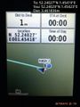
Proof. @52.2403,1.4542
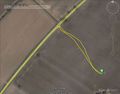
Google Earth Track Log


Achievements
Sourcerer earned the Midnight Geohash achievement
|
Sourcerer earned the Consecutive geohash achievement
|
Other geohashing expeditions on the same day
Expeditions and Plans
| 2015-04-17 | ||
|---|---|---|
| Atlanta, Georgia | NWoodruff | In the parking lot of an automotive truck repair shop in Norcross. |
| Kassel, Germany | GeorgDerReisende | The hash was in the forest of Baunatal-Rengershausen. |
| Norwich, United Kingdom | Sourcerer | Close to a field boundary, south of Peasenhall, Suffolk, UK. |