Difference between revisions of "2015-05-10 52 1"
imported>Sourcerer m (→Removed Achievement) |
imported>FippeBot m (Location) |
||
| (4 intermediate revisions by one other user not shown) | |||
| Line 3: | Line 3: | ||
| lon=1 | | lon=1 | ||
| date=2015-05-10 | | date=2015-05-10 | ||
| + | | graticule_name=Norwich, UK | ||
| + | | graticule_link=Norwich, United Kingdom | ||
}} | }} | ||
| − | |||
__NOTOC__ | __NOTOC__ | ||
== Location == | == Location == | ||
| Line 27: | Line 28: | ||
Image:2015-05-10_52_1_Sourcerer_1431297523294.jpg | Proof. [http://www.openstreetmap.org/?lat=52.60275900&lon=1.26111567&zoom=16&layers=B000FTF @52.6028,1.2611] | Image:2015-05-10_52_1_Sourcerer_1431297523294.jpg | Proof. [http://www.openstreetmap.org/?lat=52.60275900&lon=1.26111567&zoom=16&layers=B000FTF @52.6028,1.2611] | ||
Image:2015-05-10_52_1_Sourcerer_1431298032410.jpg | Oops. [http://www.openstreetmap.org/?lat=52.45871555&lon=1.43534888&zoom=16&layers=B000FTF @52.4587,1.4353] | Image:2015-05-10_52_1_Sourcerer_1431298032410.jpg | Oops. [http://www.openstreetmap.org/?lat=52.45871555&lon=1.43534888&zoom=16&layers=B000FTF @52.4587,1.4353] | ||
| + | Image:2015-05-10 52 1 Sourcerer.jpg | Track in Google Earth | ||
</gallery> | </gallery> | ||
| − | == | + | == Achievements == |
| − | {{ | + | {{Sourcerer_links |
| + | | prev = 2015-05-08 52 1 | ||
| + | | curr = 2015-05-10 52 1 | ||
| + | | next = 2015-05-11 52 1 | ||
| + | | date = 2015-05-10 | ||
| + | }} | ||
[[Category:Expeditions]] | [[Category:Expeditions]] | ||
[[Category:Expeditions with photos]] | [[Category:Expeditions with photos]] | ||
[[Category:Coordinates reached]] | [[Category:Coordinates reached]] | ||
| + | [[Category:Golf course]] | ||
| + | {{location|GB|ENG|NFK}} | ||
Latest revision as of 03:35, 15 August 2019
| Sun 10 May 2015 in Norwich, UK: 52.6027466, 1.2611388 geohashing.info google osm bing/os kml crox |
Location
A golf course in Norwich, Norfolk, UK.
Participants
Expedition
- Arrived. -- Sourcerer (talk) @52.6028,1.2611 23:39, 10 May 2015 (GMT+01:00)
This was nearly a kitty! With one hour to go, I remembered to set out and arrived with 20 minutes to spare.
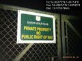
On arrival, with midnight approaching, with the headlights and street lighting, I completely failed to see the sign as I entered the golf course. After walking a few hundred metres avoiding the bunkers, I reached the hashpoint with pin-point accuracy. As I returned listening to the stridulation of crickets and the barking shrieks of two foxes, there was the "Private Property - no public right of way" sign. This expedition passed my "No damage and no disturbance to people and animals" test so I have zero guilt.
Photos
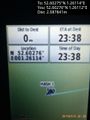
Proof. @52.6028,1.2611
Oops. @52.4587,1.4353
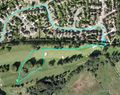
Track in Google Earth


Achievements
Expeditions and Plans
| 2015-05-10 | ||
|---|---|---|
| Norwich, United Kingdom | Sourcerer | A golf course in Norwich, Norfolk, UK. |
| Turku, Finland | Nebini | On a swamp, 16 km North from Turku Bus station. |
Sourcerer's Expedition Links
2015-05-08 52 1 - 2015-05-10 52 1 - 2015-05-11 52 1 - KML file download of Sourcerer's expeditions for use with Google Earth.