Difference between revisions of "2015-05-26 49 8"
imported>DODO (→Expedition) |
imported>FippeBot m (Location) |
||
| (5 intermediate revisions by one other user not shown) | |||
| Line 32: | Line 32: | ||
== Expedition == | == Expedition == | ||
<!-- how it all turned out. your narrative goes here. --> | <!-- how it all turned out. your narrative goes here. --> | ||
| − | Some friends had fired the grill at the rowing club and so it got pretty late until I made my way home today. On my way home I remembered, that todays hashpoint was almost on the way home and that I took my gps-device with me exactly for that reason. Although I was tired and | + | Some friends had fired the grill at the rowing club and so it got pretty late until I made my way home today. On my way home I remembered, that todays hashpoint was almost on the way home and that I took my gps-device with me exactly for that reason. Although I was tired and felt ill, I decided to go there as it seems really easy to reach, and it was such a long time since my last trial. There isn't much to tell about the rest: I followed the device to the right place on a street in Ketsch. I didn't even had to leave the car and certainly earned a speed racer achievement (as only 30 KM/h were allowed, that was an easy point), but I didn't manage to take a photo, and so I can't proof that. |
| − | After that I had a short stop, went back and took a | + | After that I had a short stop, went back and took a photo of the gps-device, where I got a zero (but only a picture of a 1, what is still good enough). Two minutes later I was back in my car and on my way home. |
At the moment my tablet didn't let my upload the pictures of that, so I can't proof that either, but I hope I will manage that. | At the moment my tablet didn't let my upload the pictures of that, so I can't proof that either, but I hope I will manage that. | ||
| Line 44: | Line 44: | ||
--> | --> | ||
<gallery perrow="5"> | <gallery perrow="5"> | ||
| + | Image:2015-05-26 49 8-1.jpg|dark grin | ||
| + | Image:2015-05-26 49 8-2.jpg|proof | ||
| + | Image:2015-05-26 49 8-3.jpg|an impression of the surrounding | ||
</gallery> | </gallery> | ||
== Achievements == | == Achievements == | ||
{{#vardefine:ribbonwidth|800px}} | {{#vardefine:ribbonwidth|800px}} | ||
| − | + | {{land geohash | |
| + | | latitude = 49 | ||
| + | | longitude = 8 | ||
| + | | date = 2015-05-26 | ||
| + | | name = DODO | ||
| + | }} | ||
| + | {{Two to the N achievement | ||
| + | | count = 6 | ||
| + | | date = 2015-05-26 | ||
| + | | latitude = 49 | ||
| + | | longitude = 8 | ||
| + | | name = DODO | ||
| + | | reached = true (optional - include if you are counting coordinates reached) | ||
| + | }} | ||
| − | |||
| − | |||
| − | |||
| − | |||
| − | |||
| − | |||
| − | |||
| − | |||
| − | |||
| − | |||
| − | |||
| − | |||
[[Category:Expeditions]] | [[Category:Expeditions]] | ||
| − | |||
[[Category:Expeditions with photos]] | [[Category:Expeditions with photos]] | ||
| − | |||
| − | |||
| − | |||
| − | |||
| − | |||
[[Category:Coordinates reached]] | [[Category:Coordinates reached]] | ||
| − | + | {{location|DE|BW|HD}} | |
| − | |||
| − | |||
| − | |||
| − | |||
| − | |||
| − | |||
| − | |||
| − | |||
| − | |||
| − | |||
| − | |||
| − | |||
| − | |||
| − | |||
| − | |||
| − | |||
| − | |||
Latest revision as of 03:47, 15 August 2019
| Tue 26 May 2015 in 49,8: 49.3633171, 8.5401630 geohashing.info google osm bing/os kml crox |
Location
On a road in Ketsch.
Participants
Plans
A short visit on my way home from the rowing club.
Expedition
Some friends had fired the grill at the rowing club and so it got pretty late until I made my way home today. On my way home I remembered, that todays hashpoint was almost on the way home and that I took my gps-device with me exactly for that reason. Although I was tired and felt ill, I decided to go there as it seems really easy to reach, and it was such a long time since my last trial. There isn't much to tell about the rest: I followed the device to the right place on a street in Ketsch. I didn't even had to leave the car and certainly earned a speed racer achievement (as only 30 KM/h were allowed, that was an easy point), but I didn't manage to take a photo, and so I can't proof that. After that I had a short stop, went back and took a photo of the gps-device, where I got a zero (but only a picture of a 1, what is still good enough). Two minutes later I was back in my car and on my way home. At the moment my tablet didn't let my upload the pictures of that, so I can't proof that either, but I hope I will manage that.
Tracklog
Photos

dark grin
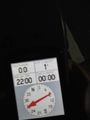
proof
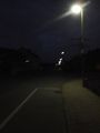
an impression of the surrounding


Achievements
DODO earned the Land geohash achievement
|
