Difference between revisions of "2015-06-09 47 -122"
imported>Thomcat ([live picture] Test of jumbo infobox [http://www.openstreetmap.org/?lat=47.74917273&lon=-122.06713839&zoom=16&layers=B000FTF @47.7492,-122.0671]) |
imported>Thomcat |
||
| Line 22: | Line 22: | ||
Soon I can geohash and have fun that is funny. | Soon I can geohash and have fun that is funny. | ||
| + | |||
| + | Ah, if only life were like Seuss. Instead, I have... traffic. Left work on time and then got into a slowdown on the two lane road leading to Duvall (and the geohash). Not far into the slowdown my phone bleeped - accident ahead. Great... | ||
| + | |||
| + | Passed the scene (4 cars) and shortly after, down the side roads leading to the hash point. Lots of trees overhead, errors abound. Parked on top of the hashpoint, then started drifting. So I backed around the corner - this was a fairly narrow road, no need to block it while I hash dance. | ||
| + | |||
| + | Walking back to my tire tracks with chalk, I got a good reading and marked the approximate point. In between drifts, I managed to upload some pictures, including a test of geohashdroid "jumbo" text (which looks the same as the regular text). Perhaps I should update my geohashdroid app? | ||
| + | |||
| + | Returning home, the accident and much of the traffic had cleared considerably, though I was a good hour later than I planned to be. | ||
== Tracklog == | == Tracklog == | ||
| Line 48: | Line 56: | ||
| − | |||
| − | |||
| − | |||
[[Category:Expeditions]] | [[Category:Expeditions]] | ||
[[Category:Expeditions with photos]] | [[Category:Expeditions with photos]] | ||
[[Category:Coordinates reached]] | [[Category:Coordinates reached]] | ||
| − | |||
| − | |||
| − | |||
| − | |||
| − | |||
| − | |||
| − | |||
| − | |||
| − | |||
| − | |||
| − | |||
Revision as of 13:12, 10 June 2015
| Tue 9 Jun 2015 in Seattle: 47.7491708, -122.0671117 geohashing.info google osm bing/os kml crox |
Location
203rd Place NE in Cottage Lake, east of Woodinville.
Participants
Plans
Stop by after work, then head home.
Expedition
Outside the office window is clear and sunny.
Soon I can geohash and have fun that is funny.
Ah, if only life were like Seuss. Instead, I have... traffic. Left work on time and then got into a slowdown on the two lane road leading to Duvall (and the geohash). Not far into the slowdown my phone bleeped - accident ahead. Great...
Passed the scene (4 cars) and shortly after, down the side roads leading to the hash point. Lots of trees overhead, errors abound. Parked on top of the hashpoint, then started drifting. So I backed around the corner - this was a fairly narrow road, no need to block it while I hash dance.
Walking back to my tire tracks with chalk, I got a good reading and marked the approximate point. In between drifts, I managed to upload some pictures, including a test of geohashdroid "jumbo" text (which looks the same as the regular text). Perhaps I should update my geohashdroid app?
Returning home, the accident and much of the traffic had cleared considerably, though I was a good hour later than I planned to be.
Tracklog
Photos
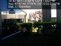
View from the office @47.7972,-122.2062
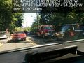
Accident site @47.7554,-122.0817
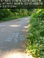
Test of jumbo infobox @47.7492,-122.0671


