Difference between revisions of "2015-06-10 52 1"
From Geohashing
imported>Sourcerer m (→Links) |
imported>Sourcerer m (→Photo) |
||
| Line 29: | Line 29: | ||
<gallery perrow="5"> | <gallery perrow="5"> | ||
Image:2015-06-10_52_1_Sourcerer_1433890802965.jpg | Proof [http://www.openstreetmap.org/?lat=52.79562056&lon=1.28846347&zoom=16&layers=B000FTF @52.7956,1.2885] | Image:2015-06-10_52_1_Sourcerer_1433890802965.jpg | Proof [http://www.openstreetmap.org/?lat=52.79562056&lon=1.28846347&zoom=16&layers=B000FTF @52.7956,1.2885] | ||
| + | Image:2015-06-10 52 1 Sourcerer.jpg | Google Earth Track Log | ||
</gallery> | </gallery> | ||
Revision as of 07:50, 27 June 2015
| Wed 10 Jun 2015 in 52,1: 52.7956071, 1.2885037 geohashing.info google osm bing/os kml crox |
Location
In a field between Aylsham and Tuttington, Norfolk, UK.
Participants
Plans
Hashpoint two of two spanning midnight. 2015-06-09 52 1 - 2015-06-10 52 1
Expedition
- Arrived. -- Sourcerer (talk) @52.7956,1.2885 00:00, 10 June 2015 (GMT+01:00)
The hashpoint was in a field of potatoes and easily reached apart from a huge irrigation machine, not in use at the time.
Photos
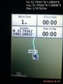
Proof @52.7956,1.2885
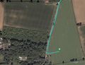
Google Earth Track Log


Achievements
Sourcerer earned the Midnight Geohash achievement
|
Sourcerer earned the Consecutive geohash achievement
|
Expeditions and Plans
| 2015-06-10 | ||
|---|---|---|
| Portland, Oregon | Jim | In a residential neighborhood in Sherwood |
| Ottawa, Ontario | Jlam | Behind a residence on Kingsmere ave in a fancy corner of Carlingwood.. |
| Pforzheim, Germany | RecentlyChanged | Gaggenau, forest |
| Norwich, United Kingdom | Sourcerer | In a field between Aylsham and Tuttington, Norfolk, UK. |
Sourcerer's Expedition Links
2015-06-09 52 1 - 2015-06-10 52 1 - 2015-06-11 52 1 - KML file download of Sourcerer's expeditions for use with Google Earth.