Difference between revisions of "2015-06-12 52 1"
imported>Sourcerer m (→Added Category) |
imported>FippeBot m (Location) |
||
| (3 intermediate revisions by one other user not shown) | |||
| Line 3: | Line 3: | ||
| lon=1 | | lon=1 | ||
| date=2015-06-12 | | date=2015-06-12 | ||
| + | | graticule_name=Norwich, UK | ||
| + | | graticule_link=Norwich, United Kingdom | ||
}} | }} | ||
__NOTOC__ | __NOTOC__ | ||
| Line 34: | Line 36: | ||
| longitude = 1 | | longitude = 1 | ||
| date = 2015-06-12 | | date = 2015-06-12 | ||
| − | |||
| − | |||
| − | |||
| − | |||
| − | |||
| − | |||
| − | |||
| name = Sourcerer | | name = Sourcerer | ||
}} | }} | ||
| Line 51: | Line 46: | ||
}} | }} | ||
| − | == | + | {{Sourcerer_links |
| − | + | | prev = 2015-06-11 52 1 | |
| − | + | | curr = 2015-06-12 52 1 | |
| + | | next = 2015-06-13 52 1 | ||
| + | | date = 2015-06-12 | ||
| + | }} | ||
[[Category:Expeditions]] | [[Category:Expeditions]] | ||
[[Category:Expeditions with photos]] | [[Category:Expeditions with photos]] | ||
[[Category:Coordinates reached]] | [[Category:Coordinates reached]] | ||
| + | {{location|GB|ENG|NFK}} | ||
Latest revision as of 04:02, 15 August 2019
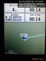
| Fri 12 Jun 2015 in Norwich, UK: 52.6096998, 1.0112412 geohashing.info google osm bing/os kml crox |
Location
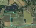
In a field south of Thuxton and the Blackwater River, Norfolk, UK.
Participants
Plans
Expedition two of two spanning midnight. 2015-06-11 52 1 - 2015-06-12 52 1 - ETA 00:00.
Expedition
I arrived 14 minutes behind schedule. There was no 3G access at the hashpoint. This was a particularly pleasing expedition. The lake was full of waterfowl twittering away. A fox barked in the woodland. There were mown tracks around the wheat field and these lead right to the hashpoint. There was one "oops" moment. On my return walk after a short, well trodden woodland track, I passed a sign - "Conservation Area No Entry Without Permission". Too late. I had already entered. This passed my "no disturbance" test and I hope I did no damage having stuck to the mown paths.
Photos
Proof.
Google Earth Tracklog


Achievements
Sourcerer earned the Midnight Geohash achievement
|
Sourcerer earned the OpenStreetMap achievement
|
Expeditions and Plans
| 2015-06-12 | ||
|---|---|---|
| Sacramento, California | Someone went | Satelite imagery puts this in the intersection of Alta Arden and Morse in S... |
| Boise, Idaho | Eldin | Just outside of a Wendy's in Meridian. |
| Fargo, North Dakota | Cliff | Southeast of Barnesville, MN |
| Spokane, Washington | Thomcat | The Blackwood housing development on a slope just west of the South Hill. |
| Stuttgart, Germany | Klaus | very near to the area of the golf club "Schönbuch" |
| Tábor, Czech Republic | Kunktator | On the field near village Ostrov near Příbram. |
| Praha, Czech Republic | Ravise | located near Stebno. |
| Barnstaple, United Kingdom | Tachibana Kanade | located in a forest in Swansea. |
| Norwich, United Kingdom | Sourcerer | In a field south of Thuxton and the Blackwater River, Norfolk, UK. |
| Bielefeld, Germany | Jan, Fippe | located in a field of wheat near Gehrde. |
Sourcerer's Expedition Links
2015-06-11 52 1 - 2015-06-12 52 1 - 2015-06-13 52 1 - KML file download of Sourcerer's expeditions for use with Google Earth.